
File:Somalia Numbered Regions.png
Size of this preview: 480 × 600 pixels. Other resolutions: 192 × 240 pixels | 512 × 640 pixels.
Original file (512 × 640 pixels, file size: 20 KB, MIME type: image/png)
| This is a file from the Wikimedia Commons. Information from its description page there is shown below. Commons is a freely licensed media file repository. You can help. |
| Description |
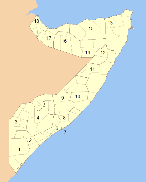
English: Blank map of Somalia showing the regions (numbered) and districts in detail together. 1- Lower Juba 2- Middle Juba 3- Gedo 4- Bay 5- Bakool 6- Lower Shabele 7- Banaadir 8- Middle Shabele 9- Hiiraan 10- Galguduud 11- Mudug 12- Nugaal 13- Bari 14- Sool 15- Sanaag 16- Togdheer 17- Woqooyi Galbeed 18- Awdal |
||
| Date | |||
| Source | Modified File:Somalia Regions and Districts.png to create image | ||
| Author | Wiz9999 | ||
| Permission (Reusing this file) |
|
||
| Other versions | File:Somalia Regions and Districts.png |
File history
Click on a date/time to view the file as it appeared at that time.
| Date/Time | Thumbnail | Dimensions | User | Comment | |
|---|---|---|---|---|---|
| current | 00:13, 6 June 2009 | | 512 × 640 (20 KB) | Wiz9999 | {{Information |Description={{en|1=Blank map of Somalia showing the regions (numbered) and districts in detail together.}} |Source=Modified File:Somalia Regions and Districts.png to create image |Author=Wiz9999 |Date=2009-06-05 |Permi |
File usage
The following pages on the English Wikipedia use this file (pages on other projects are not listed):
Global file usage
The following other wikis use this file:
- Usage on als.wikipedia.org
- Usage on ar.wikipedia.org
- Usage on azb.wikipedia.org
- Usage on bg.wikipedia.org
- Usage on bs.wikipedia.org
- Usage on da.wikipedia.org
- Usage on de.wikipedia.org
- Usage on el.wikipedia.org
- Usage on es.wikipedia.org
- Usage on eu.wikipedia.org
- Usage on fa.wikipedia.org
- Usage on is.wikipedia.org
- Usage on it.wikipedia.org
- Usage on ko.wikipedia.org
- Usage on li.wikipedia.org
- Usage on mk.wikipedia.org
- Usage on mzn.wikipedia.org
- Usage on no.wikipedia.org
- Usage on pl.wikipedia.org
- Usage on ps.wikipedia.org
- Usage on pt.wikipedia.org
- Usage on ro.wikipedia.org
- Usage on ru.wikipedia.org
- Usage on so.wikipedia.org
- Usage on trv.wikipedia.org
- Usage on tr.wikipedia.org
- Usage on ur.wikipedia.org
- Usage on zh-classical.wikipedia.org
- Usage on zh.wikipedia.org