
File:Slovak Catholic Cathedral of the Transfiguration, Markham, Ontario (2480438345).jpg

Original file (858 × 572 pixels, file size: 201 KB, MIME type: image/jpeg)
| This is a file from the Wikimedia Commons. Information from its description page there is shown below. Commons is a freely licensed media file repository. You can help. |
.jpg)
Summary
| Description |
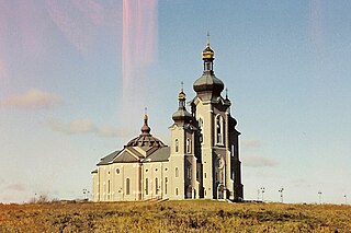
The Cathedral of the Transfiguration is a Slovak Byzantine Rite Roman Catholic former cathedral located in the community of Victoria Square in Markham, Ontario, Canada. The cathedral was built in a rural area north of the city of Toronto and was built to serve Slovak Catholics throughout the Greater Toronto Area. The Cathedral was conceived and funded by Stephen B. Roman, a Slovak immigrant to Canada who had built up the Denison Mines corporation. Roman both funded and designed the building, modeling the structure on the church in Velky Ruskov, the Slovak village he was raised in. The cathedral was built on a donated portion of his Romandale estate. Among its features is the world's largest three bell carillon, with the French made bells by the Fonderie Paccard, weighing 32,000 pounds, and 300 cm diameter. The mosaics are reputed to contain about 5 million pieces. The cathedral was built to hold 1000 worshipers serving a community of about 5000 Byzantine Rite Catholics in the GTA and 35,000 across Canada. The central tower rises 63 metres (about 20 storeys) and is topped by a gold onion dome. The church was designed by Donald Buttress, a renowned architect whose claim to fame is overhauling Westminster Abbey. It is a significant landmark east of the 404 highway. en.wikipedia.org/wiki/Cathedral_of_the_Transfiguration_(M... creativecommons.org/licenses/by-sa/3.0/ |
| Date | |
| Source | Slovak Catholic Cathedral of the Transfiguration, Markham, Ontario |
| Author | Ken Lund from Reno, Nevada, USA |
| Camera location | | View this and other nearby images on: OpenStreetMap |
|---|
.jpg¶ms=043.893934_N_-079.372959_E_globe:Earth_type:camera_source:Flickr_&language=en)
Licensing
- You are free:
- to share – to copy, distribute and transmit the work
- to remix – to adapt the work
- Under the following conditions:
- attribution – You must give appropriate credit, provide a link to the license, and indicate if changes were made. You may do so in any reasonable manner, but not in any way that suggests the licensor endorses you or your use.
- share alike – If you remix, transform, or build upon the material, you must distribute your contributions under the same or compatible license as the original.
| This image was originally posted to Flickr by Ken Lund at https://flickr.com/photos/75683070@N00/2480438345. It was reviewed on 19 December 2016 by FlickreviewR and was confirmed to be licensed under the terms of the cc-by-sa-2.0. |
File history
Click on a date/time to view the file as it appeared at that time.
| Date/Time | Thumbnail | Dimensions | User | Comment | |
|---|---|---|---|---|---|
| current | 14:47, 19 December 2016 | | 858 × 572 (201 KB) | Mindmatrix | Transferred from Flickr via Flickr2Commons |
.jpg)