
File:Site of former Lower Pontnewydd railway station, Cwmbran (Geograph 3257876 by Jaggery).jpg
No higher resolution available.
Site_of_former_Lower_Pontnewydd_railway_station,_Cwmbran_(Geograph_3257876_by_Jaggery).jpg (640 × 480 pixels, file size: 82 KB, MIME type: image/jpeg)
| This is a file from the Wikimedia Commons. Information from its description page there is shown below. Commons is a freely licensed media file repository. You can help. |
.jpg)
Summary
| Description |
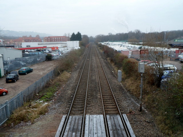
English: Site of former Lower Pontnewydd railway station, Cwmbran Viewed from Station Road bridge looking north. A 1940s map shows that Lower Pontnewydd railway station was located here, immediately north of the bridge. Passenger services at Lower Pontnewydd railway station ceased in 1958. |
| Date | |
| Source | From geograph.org.uk |
| Author | Jaggery |
| Permission (Reusing this file) |
Creative Commons Attribution Share-alike license 2.0 |
| Attribution (required by the license) | Jaggery / Site of former Lower Pontnewydd railway station, Cwmbran / |
| Camera location | | View this and other nearby images on: OpenStreetMap |
|---|
.jpg¶ms=051.659950_N_-003.016500_E_globe:Earth_type:camera_source:geograph-osgb36(ST29789617)_heading:0.00&language=en)
| Object location | | View this and other nearby images on: OpenStreetMap |
|---|
.jpg¶ms=051.660310_N_-003.016500_E_globe:Earth_class:object_type:object_source:geograph-osgb36(ST29789621)_heading:0.00&language=en)
Licensing

|
This image was taken from the Geograph project collection. See this photograph's page on the Geograph website for the photographer's contact details. The copyright on this image is owned by Jaggery and is licensed for reuse under the Creative Commons Attribution-ShareAlike 2.0 license.
|
This file is licensed under the Creative Commons Attribution-Share Alike 2.0 Generic license.
Attribution: Jaggery
- You are free:
- to share – to copy, distribute and transmit the work
- to remix – to adapt the work
- Under the following conditions:
- attribution – You must give appropriate credit, provide a link to the license, and indicate if changes were made. You may do so in any reasonable manner, but not in any way that suggests the licensor endorses you or your use.
- share alike – If you remix, transform, or build upon the material, you must distribute your contributions under the same or compatible license as the original.
File history
Click on a date/time to view the file as it appeared at that time.
| Date/Time | Thumbnail | Dimensions | User | Comment | |
|---|---|---|---|---|---|
| current | 08:40, 12 February 2015 | | 640 × 480 (82 KB) | Lamberhurst | == {{int:filedesc}} == {{Information |Description={{en|1='''Site of former Lower Pontnewydd railway station, Cwmbran'''<br/> Viewed from Station Road bridge looking north. A 1940s map shows that {{w|Lower Pontnewydd railway station}} was located here,... |
File usage
The following pages on the English Wikipedia use this file (pages on other projects are not listed):
Global file usage
The following other wikis use this file:
- Usage on www.wikidata.org
.jpg)