
File:Sindh Districts.svg

Size of this PNG preview of this SVG file: 490 × 600 pixels. Other resolutions: 196 × 240 pixels | 392 × 480 pixels | 627 × 768 pixels | 837 × 1,024 pixels | 1,673 × 2,048 pixels | 817 × 1,000 pixels.
Original file (SVG file, nominally 817 × 1,000 pixels, file size: 39 KB)
| This is a file from the Wikimedia Commons. Information from its description page there is shown below. Commons is a freely licensed media file repository. You can help. |
Summary
| Description |
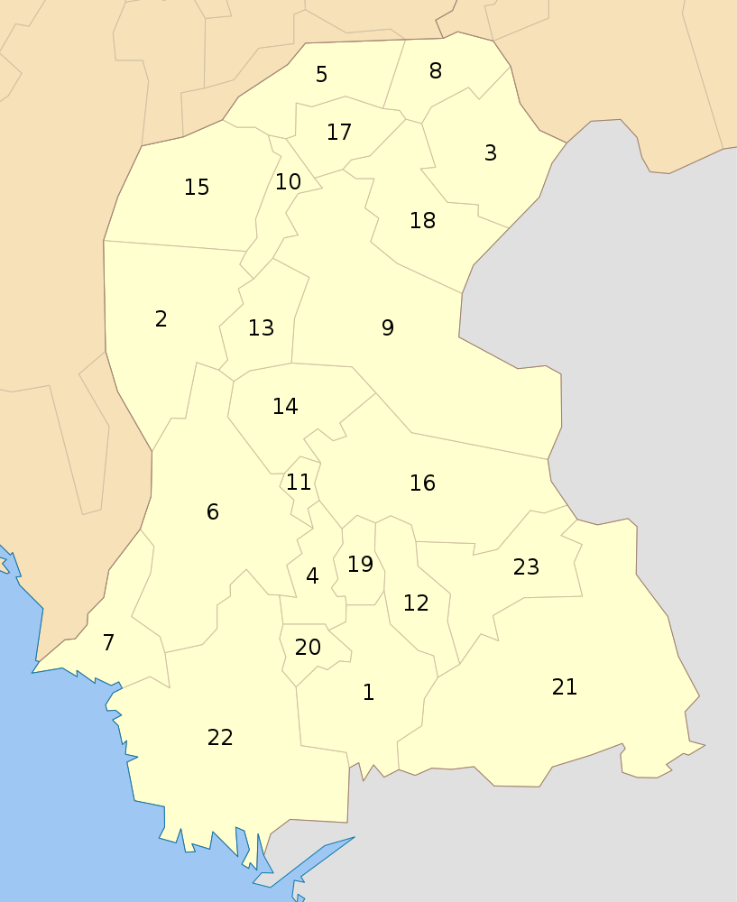
English: Districts of Sindh as of Oct 2010 |
| Date | |
| Source | Own work |
| Author | Schajee |
| SVG development |
Licensing
| I, the copyright holder of this work, release this work into the public domain. This applies worldwide. In some countries this may not be legally possible; if so: I grant anyone the right to use this work for any purpose, without any conditions, unless such conditions are required by law. |
File history
Click on a date/time to view the file as it appeared at that time.
| Date/Time | Thumbnail | Dimensions | User | Comment | |
|---|---|---|---|---|---|
| current | 19:28, 5 April 2020 | | 817 × 1,000 (39 KB) | اُردو | Reverted to version as of 14:04, 31 July 2016 (UTC) |
| 15:01, 2 April 2020 |  | 817 × 1,000 (54 KB) | مومن خان ڏاهري | File uploaded using svgtranslate tool (https://tools.wmflabs.org/svgtranslate/). Added translation for en. | |
| 14:04, 31 July 2016 |  | 817 × 1,000 (39 KB) | Furfur | enlarged the numbers, such that they can be read in the preview | |
| 21:56, 10 October 2010 |  | 817 × 1,000 (43 KB) | Schajee | {{Information |Description={{en|1=Districts of Sindh as of Oct 2010}} |Source={{own}} |Author=Schajee |Date= |Permission= |other_versions= }} Category:Maps of Pakistan |
File usage
The following pages on the English Wikipedia use this file (pages on other projects are not listed):
- City Districts of Pakistan
- Dadu District
- Districts of Pakistan
- Federally Administered Tribal Areas
- Gulshan District
- Hyderabad District, Sindh
- Jacobabad District
- Jamshoro District
- Karachi
- Karachi District (South)
- Kashmore District
- Keamari District
- Khairpur District
- Korangi District
- Larkana District
- List of districts in Sindh
- Malir District
- Matiari District
- Mirpur Khas District
- Naushahro Feroze District
- Nazimabad District
- Orangi District
- Pakistan
- Qambar Shahdadkot District
- Raharki
- Sanghar District
- Shaheed Benazirabad District
- Shikarpur District
- Sindh
- Sujawal District
- Sukkur District
- Tando Allahyar District
- Tando Muhammad Khan District
- Tharparkar
- Thatta District
- Umerkot District
- Template:Districts of Sindh
- Template:List of districts of Pakistan
- Draft:Sukkur Division
Global file usage
The following other wikis use this file:
- Usage on bn.wikipedia.org
- দাদূ জেলা
- হায়দ্রাবাদ জেলা, সিন্ধু
- টেমপ্লেট:সিন্ধুর জেলা
- জামশরু জেলা
- মতিয়ারি জেলা
- তান্দো আল্লাহইয়ার জেলা
- তান্দো মুহাম্মাদ খান জেলা
- বাদিন জেলা
- থাট্টা জেলা
- সুজাওয়াল জেলা
- করাচি কেন্দ্রীয় জেলা
- পূর্ব করাচি জেলা
- দক্ষিণ করাচি জেলা
- পশ্চিম করাচি জেলা
- করাঙ্গি জেলা
- মালির জেলা
- জ্যাকোবাবাদ জেলা
- কাশমোর জেলা
- লারকানা জেলা
- কাম্বার শাহাদাদকোট জেলা
- শিকারপুর জেলা
- মিরপুর খাস জেলা
- সংহার জেলা
- থারপার্কার জেলা
- উমরকোট জেলা
- ঘোটকি জেলা
- খায়েরপুর জেলা
- সুক্কুর জেলা
- শহীদ বেনাজিরাবাদ জেলা
- নওশহরো ফিরোজি জেলা
- Usage on de.wikipedia.org
- Usage on fa.wikipedia.org
View more global usage of this file.