
File:Shenley Tower - geograph.org.uk - 682775.jpg
Size of this preview: 450 × 600 pixels. Other resolutions: 180 × 240 pixels | 480 × 640 pixels.
Original file (480 × 640 pixels, file size: 74 KB, MIME type: image/jpeg)
| This is a file from the Wikimedia Commons. Information from its description page there is shown below. Commons is a freely licensed media file repository. You can help. |
Summary
| Description |
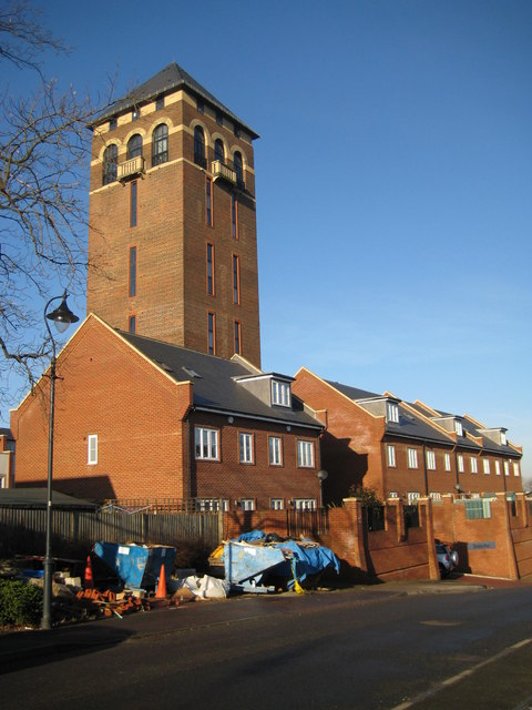
English: Shenley Tower This landmark Italianate structure was originally built in 1932 as the water tower for the former Shenley Hospital, which closed in the 1990s. As part of the redevelopment of the hospital site for residential purposes the tower has been converted into six duplex apartments, which were completed in 2005. The houses clustered around the base of the tower form part of the gated Blenheim Mews development. The builders' skips are an indication of the recent completion of the construction work.
The top of the tower is reputedly about 49 metres, or about 160 feet, above ground level, and is said to offer views across Hertfordshire, London, Essex, Bedfordshire and Buckinghamshire. This view was taken from Laxton Gardens. (From a cartographical and Geograph point of view the tower more or less straddles the 201000 Northing grid line. From the Ordnance Survey 1:10,000 scale mapping, the façade of the tower on the left side of the photograph is in this grid square TL1800, while the façade on the right side is in TL1801.) |
| Date | |
| Source | From geograph.org.uk |
| Author | Nigel Cox |
| Attribution (required by the license) | Nigel Cox / Shenley Tower / |
| Camera location | | View this and other nearby images on: OpenStreetMap |
|---|
_heading:270.00&language=en)
| Object location | | View this and other nearby images on: OpenStreetMap |
|---|
_heading:270.00&language=en)
Licensing

|
This image was taken from the Geograph project collection. See this photograph's page on the Geograph website for the photographer's contact details. The copyright on this image is owned by Nigel Cox and is licensed for reuse under the Creative Commons Attribution-ShareAlike 2.0 license.
|
This file is licensed under the Creative Commons Attribution-Share Alike 2.0 Generic license.
Attribution: Nigel Cox
- You are free:
- to share – to copy, distribute and transmit the work
- to remix – to adapt the work
- Under the following conditions:
- attribution – You must give appropriate credit, provide a link to the license, and indicate if changes were made. You may do so in any reasonable manner, but not in any way that suggests the licensor endorses you or your use.
- share alike – If you remix, transform, or build upon the material, you must distribute your contributions under the same or compatible license as the original.
File history
Click on a date/time to view the file as it appeared at that time.
| Date/Time | Thumbnail | Dimensions | User | Comment | |
|---|---|---|---|---|---|
| current | 02:40, 8 February 2011 | | 480 × 640 (74 KB) | GeographBot | == {{int:filedesc}} == {{Information |description={{en|1=Shenley Tower This landmark Italianate structure was originally built in 1932 as the water tower for the former Shenley Hospital, which closed in the 1990s. As part of the redevelopment of the hospi |
File usage
The following pages on the English Wikipedia use this file (pages on other projects are not listed):