
File:Serbia in the Yugoslav Wars.png
Size of this preview: 800 × 555 pixels. Other resolutions: 320 × 222 pixels | 640 × 444 pixels | 1,024 × 711 pixels | 1,285 × 892 pixels.
Original file (1,285 × 892 pixels, file size: 130 KB, MIME type: image/png)
| This is a file from the Wikimedia Commons. Information from its description page there is shown below. Commons is a freely licensed media file repository. You can help. |

|
This military map image could be re-created using vector graphics as an SVG file. This has several advantages; see Commons:Media for cleanup for more information. If an SVG form of this image is available, please upload it and afterwards replace this template with
{{vector version available|new image name}}.
It is recommended to name the SVG file “Serbia in the Yugoslav Wars.svg”—then the template Vector version available (or Vva) does not need the new image name parameter. |
Summary
| Description |
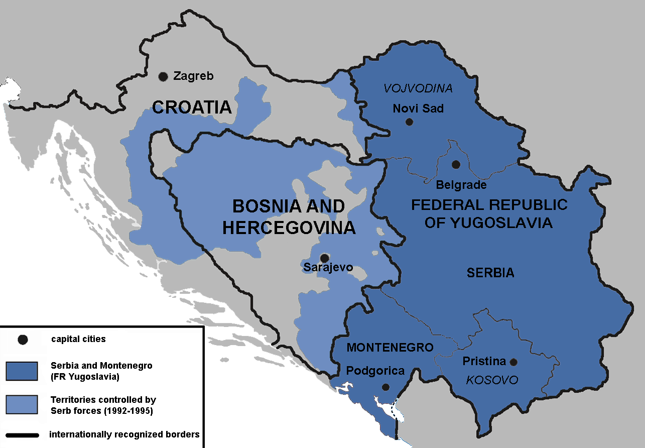
English: Territories of the Republic of Bosnia and Herzegovina and the Republic of Croatia controlled by the Serb forces, after the Operation Corridor (July 1992) in the Yugoslav Wars.
According to the prosecution of War Crimes Tribunal, "Serbian forces" included Yugoslav Army, Serb Territorial Defense of Bosnia and Herzegovina and Croatia, Republic of Srpska Krajina Army, Army of the Republika Srpska, territorial defense of Serbia and Montenegro, Police of Serbia and Police of Republika Srpska, including national security, special police forces of Krajina known as "Martićevci", as well as all Serbian paramilitary forces and volunteer units.[1] Croatia declared independence on June 25, 1991. It was internationally recognized on 15 January 1992 by the United Nations. Bosnia and Herzegovina declared independence on March 5 1992. It was internationally recognized on 22 May 1992 by the United Nations. Serbia and Montenegro proclaimed FR Yugoslavia as a sole successor state of SFR Yugoslavia, on April 27 1992. It remained unrecognized during the conflict (1991-1995). |
||
| Date | |||
| Source | Own work | ||
| Author | Mladifilozof | ||
| Permission (Reusing this file) |
I, the copyright holder of this work, hereby publish it under the following licenses: This file is licensed under the Creative Commons Attribution-Share Alike 3.0 Unported license.
You may select the license of your choice. |
||
| Other versions |
|


- ↑ Šešelj ICTY Case information sheet (retrieved 10.07.2009.)
File history
Click on a date/time to view the file as it appeared at that time.
| Date/Time | Thumbnail | Dimensions | User | Comment | |
|---|---|---|---|---|---|
| current | 16:09, 13 January 2019 | | 1,285 × 892 (130 KB) | Illegitimate Barrister | labelled FRoY |
| 23:50, 11 August 2012 |  | 1,285 × 892 (106 KB) | DIREKTOR | Small fix | |
| 00:14, 3 April 2012 |  | 1,285 × 892 (76 KB) | Phoenix B 1of3 | The blue map appears clearer and easier to understand | |
| 11:34, 2 April 2012 |  | 1,285 × 892 (83 KB) | Fezz5555 | Returning the original previous image of the author. | |
| 23:27, 10 December 2011 |  | 1,285 × 892 (76 KB) | DIREKTOR | Colour | |
| 04:12, 22 February 2010 |  | 1,285 × 892 (83 KB) | Mladifilozof | improved | |
| 20:24, 16 February 2010 |  | 1,285 × 892 (89 KB) | Mladifilozof | {{Information |Description={{en|1=Territories of the Republic of Bosnia and Herzegovina and the Republic of Croatia controlled by the Serbian forces during the [[:en:Yugoslav Wars|Yugo |
File usage
The following pages on the English Wikipedia use this file (pages on other projects are not listed):
- Agreement on Friendship and Cooperation between Bosnia and Herzegovina and Croatia
- Bosnian genocide
- Croatian War of Independence
- Greater Serbia
- Proposed secession of Republika Srpska
- Republika Srpska (1992–1995)
- Serbia in the Yugoslav Wars
- Siege of Sarajevo
- Talk:Bosnian War/Archive 3
- Talk:Bosnian genocide/Archive 4
- Talk:History of Serbia/Archive 1
- Talk:Joint criminal enterprise
- Talk:Operation Corridor 92/Archive 1
- Talk:Republic of Bosnia and Herzegovina
- Talk:Republic of Serbia (1992–2006)/Archive 1
- Talk:Republic of Serbian Krajina/Archive 3
- Talk:Republika Srpska (1992–1995)
- Talk:Russia/Archive 16
- Talk:Siege of Sarajevo/Archive 1
- Talk:Slobodan Milošević/Archive 2
- User:Falcaorib
- User:Phoenix B 1of3/Stop Greater Serbia
- Wikipedia:Graphics Lab/Map workshop/Archive/Oct 2011
Global file usage
The following other wikis use this file:
- Usage on ar.wikipedia.org
- Usage on azb.wikipedia.org
- Usage on az.wikipedia.org
- Usage on be.wikipedia.org
- Usage on bg.wikipedia.org
- Usage on bs.wikipedia.org
- Usage on ca.wikipedia.org
- Usage on cs.wikipedia.org
- Usage on da.wikipedia.org
- Usage on de.wikipedia.org
- Usage on el.wikipedia.org
- Usage on es.wikipedia.org
- Usage on eu.wikipedia.org
- Usage on fr.wikipedia.org
- Usage on gl.wikipedia.org
- Usage on he.wikipedia.org
- Usage on hr.wikipedia.org
- Usage on hu.wikipedia.org
- Usage on it.wikipedia.org
- Usage on ko.wikipedia.org
- Usage on mk.wikipedia.org
- Usage on no.wikipedia.org
- Usage on pt.wikipedia.org
- Usage on ro.wikipedia.org
- Usage on ru.wikipedia.org
- Usage on sc.wikipedia.org
- Usage on sh.wikipedia.org
- Usage on sv.wikipedia.org
- Usage on th.wikipedia.org
View more global usage of this file.