
File:Selseyiland.png
Size of this preview: 753 × 600 pixels. Other resolutions: 301 × 240 pixels | 603 × 480 pixels | 964 × 768 pixels | 1,280 × 1,020 pixels | 2,185 × 1,741 pixels.
Original file (2,185 × 1,741 pixels, file size: 599 KB, MIME type: image/png)
| This is a file from the Wikimedia Commons. Information from its description page there is shown below. Commons is a freely licensed media file repository. You can help. |
Summary
| Description |
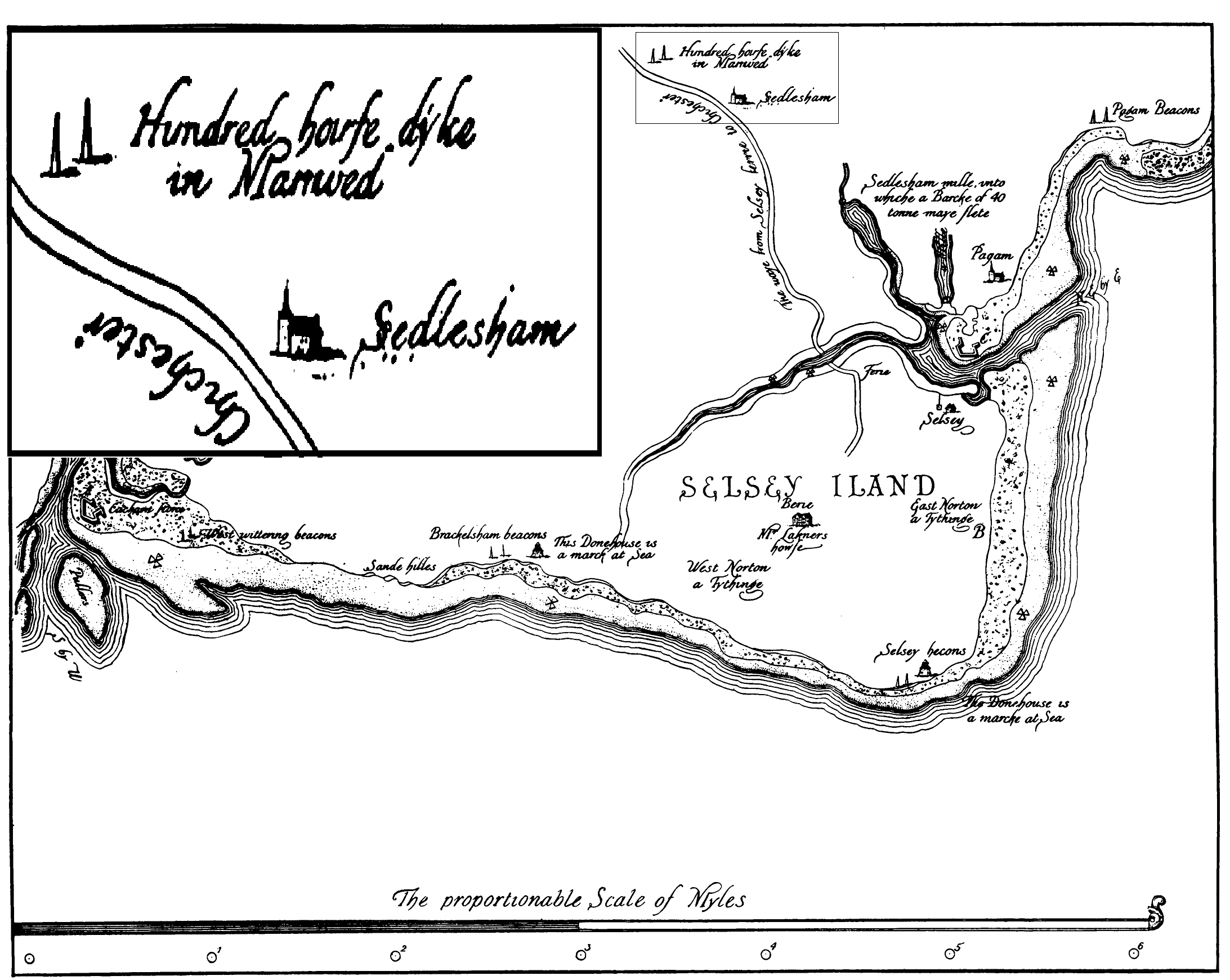
English: This is part of a survey of the Sussex coast made by Sir Thomas Palmer Knight and Walter Coverte and records the section of the coast around Selsey Bill. Sir Thomas Palmer Knight and Walter Coverte were Deputy Lieutenants of Sussex and its coast line. The survey was made during the reign of Queen Elizabeth I of England, in the year 1578, and was commissioned as part of a project to build up defences against the Spanish Armada. |
| Date | |
| Source | Selsey Historic and Prehistoric. Edward Heron Allen. |
| Author | Thomas Palmer Knight and Walter Coverte |
Licensing
|
This is a faithful photographic reproduction of a two-dimensional, public domain work of art. The work of art itself is in the public domain for the following reason:
The official position taken by the Wikimedia Foundation is that "faithful reproductions of two-dimensional public domain works of art are public domain".
This photographic reproduction is therefore also considered to be in the public domain in the United States. In other jurisdictions, re-use of this content may be restricted; see Reuse of PD-Art photographs for details. | ||||
File history
Click on a date/time to view the file as it appeared at that time.
| Date/Time | Thumbnail | Dimensions | User | Comment | |
|---|---|---|---|---|---|
| current | 08:00, 14 October 2010 | | 2,185 × 1,741 (599 KB) | Wilfridselsey | Added detail inset. (({{Information |Description={{en|1=Armada Map of Selsey created in 16th Century}} |Source=Selsey Historic and Prehistoric. Edward Heron Allen. |Author=Anonymous |Date=1587 |Permission=See Below |other_versions= }} == Licensing == {{P |
| 14:31, 13 October 2010 |  | 400 × 318 (55 KB) | Wilfridselsey | ({{Information |Description={{en|1=Armada Map of Selsey created in 16th Century}} |Source=Selsey Historic and Prehistoric. Edward Heron Allen. |Author=Anonymous |Date=1587 |Permission=See Below |other_versions= }} == Licensing == {{PD-art}}) | |
| 14:28, 13 October 2010 |  | 4,369 × 3,481 (677 KB) | Wilfridselsey | Smaller file | |
| 14:26, 13 October 2010 |  | 4,369 × 3,481 (612 KB) | Wilfridselsey | Better copy | |
| 13:13, 13 October 2010 |  | 2,149 × 1,675 (291 KB) | Wilfridselsey | {{Information |Description={{en|1=Armada Map of Selsey created in 16th Century}} |Source=Selsey Historic and Prehistoric. Edward Heron Allen. |Author=Anonymous |Date=1587 |Permission=See Below |other_versions= }} == Licensing == {{PD-art}} |
File usage
The following pages on the English Wikipedia use this file (pages on other projects are not listed):