
File:Scotoplanes globosa and crab.jpg

Size of this preview: 800 × 450 pixels. Other resolutions: 320 × 180 pixels | 640 × 360 pixels | 1,024 × 576 pixels | 1,280 × 720 pixels | 1,920 × 1,080 pixels.
Original file (1,920 × 1,080 pixels, file size: 1.08 MB, MIME type: image/jpeg)
| This is a file from the Wikimedia Commons. Information from its description page there is shown below. Commons is a freely licensed media file repository. You can help. |
Summary
| Description |
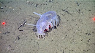
Français : Un concombre de mer "cochon de mer" (Scotoplanes globosa), photographié à 1282m de profondeur. Un crabe d'une espèce non identifiée (famille Lithodidae) se dissimule dessous.
(Photo NOAA/MBARI) English: A sea cucumber (Scotoplanes globosa) appearing to "shelter" the crab (family Lithodidae). The recorded raw location and environmental measurements at time of capture are Lat= 36.694919 Lon= -122.297988 Depth= 1282.34 m Temp= 3.145 C Sal= 34.523 PSU Oxy= 0.789 ml/l Xmiss= 87.66%. In 2004, the ship Med Taipei, lost 15 shipping containers just outside of Monterey Bay. Later that same year, MBARI discovered one of these containers resting on the seafloor at 1280 meters below the surface. From March 8-10, 2011, MBNMS and MBARI scientists revisited this shipping container to document its condition and collect sediment cores and organisms for further study. |
| Date | |
| Source | http://www.sanctuarysimon.org/photos/photo_info.php?photoID=3951&search=kw&s=0&page=1 |
| Author | NOAA/MBARI |
| Permission (Reusing this file) |
| Camera location | | View this and other nearby images on: OpenStreetMap |
|---|
Licensing
This file is licensed under the Creative Commons Attribution-Share Alike 3.0 Unported license.
- You are free:
- to share – to copy, distribute and transmit the work
- to remix – to adapt the work
- Under the following conditions:
- attribution – You must give appropriate credit, provide a link to the license, and indicate if changes were made. You may do so in any reasonable manner, but not in any way that suggests the licensor endorses you or your use.
- share alike – If you remix, transform, or build upon the material, you must distribute your contributions under the same or compatible license as the original.
File history
Click on a date/time to view the file as it appeared at that time.
| Date/Time | Thumbnail | Dimensions | User | Comment | |
|---|---|---|---|---|---|
| current | 15:49, 15 April 2020 | | 1,920 × 1,080 (1.08 MB) | Christian Ferrer | quality is less good, see Commons:Overwriting existing files |
| 08:17, 26 October 2016 |  | 862 × 862 (598 KB) | Epipelagic | crop, sharpen and increase contrast | |
| 08:42, 3 June 2014 |  | 1,920 × 1,080 (1.08 MB) | FredD | User created page with UploadWizard |
File usage
The following pages on the English Wikipedia use this file (pages on other projects are not listed):
- Elasipodida
- Elpidiidae
- List of echinoderm orders
- Scotoplanes
- Scotoplanes globosa
- Sea cucumber
- User:Aglantha/sandbox
- User:Anemone01/sandbox
- User:Biostudent07/sandbox
- User:Dronebogus/Basement
- User:Ginger022693/sandbox
- User:Jellyfish993/sandbox
- User:Jill-nye/sandbox
- User:KathrynMillerx/sandbox
- User:Keke2702/sandbox
- User:Laevis123/sandbox
- User:Mainlander123/sandbox
- User:MarineGirl96/sandbox
- User:Marinebio3711/sandbox
- User:Platypus9108/sandbox
- User:Somniosus12/sandbox
- User:SpiralShapedSea/sandbox
- User:Tdl120300/sandbox
- User:Tursiops2276/sandbox
Global file usage
The following other wikis use this file:
- Usage on ceb.wikipedia.org
- Usage on de.wikipedia.org
- Usage on eo.wikipedia.org
- Usage on es.wikipedia.org
- Usage on fa.wikipedia.org
- Usage on fr.wikipedia.org
- Usage on it.wikipedia.org
- Usage on ko.wikipedia.org
- Usage on la.wikipedia.org
- Usage on nl.wikipedia.org
- Usage on pl.wiktionary.org
- Usage on pt.wikipedia.org
- Usage on sv.wikipedia.org
- Usage on tr.wikipedia.org
- Usage on zh.wikipedia.org