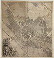
File:Schmettau Plan de la Ville de Berlin 1750.jpg

Page contents not supported in other languages.
This is a file from the Wikimedia Commons
From Wikipedia, the free encyclopedia

Original file(9,358 × 13,410 pixels, file size: 74.57 MB, MIME type: image/jpeg)

Warning The original file is very high-resolution. It might not load properly or could cause your browser to freeze when opened at full size.

Summary

Warning The original file is very high-resolution. It might not load properly or could cause your browser to freeze when opened at full size.
Title
Plan de la Ville de Berlin Levé et dessiné par Ordre et privilege privatis du Roy Sous la Direction du Marchall Comte de Schmettau par Hildner aprouvé par l'Academie Royale de Science a Berlin Gravé sous la Direction de G. F. Schmidt Graveur du Roy
Description
Deutsch: Der Plan wurde nach einer um 1747 abgeschlossenen Neuvermessung Berlins angefertigt und wird als äußerst zuverlässige Quelle angesehen. Der Titel ist in einer sehr kunstvollen Allegorie des Kupferstechers Georg Friedrich Schmidt im linken unteren Blatt eingefasst. Die Karte selbst ist hingegen laut Jacoby von Friedrich Gottlieb Berger gestochen. Unter dem Plan befindet sich ein "Prospect der Stadt Berlin von Süden gen Norden" sowie drei weitere Ansichten.

Bei diesem Exemplar handelt es sich um eine 1750 korrigierte Version der ursprünglichen Ausgabe von 1748; lediglich zu erkennen an verschiedentlichen überklebten Stellen. Korrigiert wurden:

  1. Das Octagon (vor dem Potsdamer Tor ist der Friedrichstädtische Kirchhof hinzugekommen)
  2. Das Prinz Heinrich Palais
  3. Umgebung des Invalidenhauses (Gärten nachgetragen)
  4. Die Gegend zwischen den Bastionen 12 und 13 die (Alte) Friedrichsbrücke (später auch Herkulesbrücke genannt)
  5. Gebiet der Bollwerke 6 und 7 bei Neukölln
Später (vermutlich im 19. Jahrhundert) erschien auch eine Neuauflage, bei der die überklebten Stellen auf den Druckplatten geändert wurden.
Date
Source Moll's map collection (online)
Creator
Friedrich August Hildner (Vermessungsingenieur), Georg Friedrich Schmidt (Titelverzierung), Samuel Graf von Schmettau (Produktionsleiter)
 Geotemporal data
Map location Berlin
Scale 1:4,333
Heading
Bounding box
N: 52.5595449°N
W: 13.3483336°E E: 13.4593887°E
S: 52.4821191°N
Georeferencing Georeference the map in Wikimaps Warper If inappropriate please set warp_status = skip to hide.
 Bibliographic data
Language German
 Archival data
Moravská zemská knihovna (Moll's map collection)
Accession number
Moll-0005.028,4
Dimensions height: 166.2 cm (65.4 in); width: 116.5 cm (45.8 in)
dimensions QS:P2048,166.2U174728
dimensions QS:P2049,116.5U174728
(height: 131 cm (51.5 in); width: 116 cm (45.6 in)
dimensions QS:P2048,131.0U174728
dimensions QS:P2049,116.0U174728
nur der Plan), bestehend aus 4 Einzelblättern zu je ca. 89 x 62 cm
Medium copper engraving print
Notes

Literatur

  • G. Schulz, "Die Stadtpläne von Berlin 1652-1920", Nr. 111
Other versions

Licensing

This is a faithful photographic reproduction of a two-dimensional, public domain work of art. The work of art itself is in the public domain for the following reason:
Public domain

This work is in the public domain in its country of origin and other countries and areas where the copyright term is the author's life plus 70 years or fewer.


This work is in the public domain in the United States because it was published (or registered with the U.S. Copyright Office) before January 1, 1929.

The official position taken by the Wikimedia Foundation is that "faithful reproductions of two-dimensional public domain works of art are public domain".
This photographic reproduction is therefore also considered to be in the public domain in the United States. In other jurisdictions, re-use of this content may be restricted; see Reuse of PD-Art photographs for details.

File history

Click on a date/time to view the file as it appeared at that time.

Date/TimeThumbnailDimensionsUserComment
current16:01, 9 May 2014Thumbnail for version as of 16:01, 9 May 20149,358 × 13,410 (74.57 MB)Alexrk2new upload due to problems with IIP
15:56, 4 May 2014Thumbnail for version as of 15:56, 4 May 20149,358 × 13,410 (74.53 MB)Alexrk2{{Information |Description='''Plan de la Ville de Berlin''' Levé et dessiné par Ordre et privilege privatis du Roy Sous la Direction du Marchall Comte de Schmettau par Hildner aprouvé par l'Academie Royale de Science a Berlin Gravé sous la Directio...
The following pages on the English Wikipedia use this file (pages on other projects are not listed):

Global file usage

The following other wikis use this file:

Metadata