
File:Schleswig-Holstein.png

Size of this preview: 594 × 599 pixels. Other resolutions: 238 × 240 pixels | 476 × 480 pixels | 761 × 768 pixels | 1,123 × 1,133 pixels.
Original file (1,123 × 1,133 pixels, file size: 165 KB, MIME type: image/png)
| This is a file from the Wikimedia Commons. Information from its description page there is shown below. Commons is a freely licensed media file repository. You can help. |
Summary
| Description |
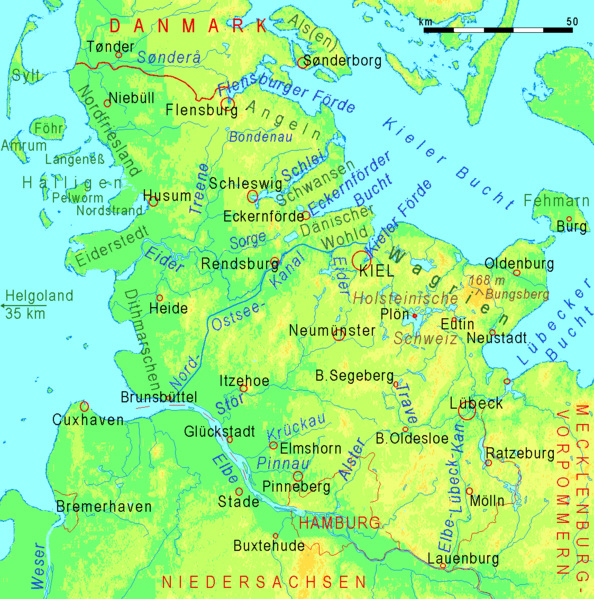
Deutsch: Physische Karte von Schleswig-Holstein mit Namen von Landschaften, Flüssen und Städten English: physical map of Schleswig-Holstein with names of landscapes, rivers, and cities Dansk: Fysisk kort over Slesvig-Holsten med landskabsnavne, floder og byer |
| Source | http://www.maps-for-free.com |
| Author | Ulamm 19:02, 5 February 2008 (UTC) |
| Other versions | Image:SH16+fl+gr.png (unlabelled/unbeschriftet) |
Licensing
This file is licensed under the Creative Commons Attribution-Share Alike 3.0 Unported license.
- You are free:
- to share – to copy, distribute and transmit the work
- to remix – to adapt the work
- Under the following conditions:
- attribution – You must give appropriate credit, provide a link to the license, and indicate if changes were made. You may do so in any reasonable manner, but not in any way that suggests the licensor endorses you or your use.
- share alike – If you remix, transform, or build upon the material, you must distribute your contributions under the same or compatible license as the original.
File history
Click on a date/time to view the file as it appeared at that time.
| Date/Time | Thumbnail | Dimensions | User | Comment | |
|---|---|---|---|---|---|
| current | 12:14, 21 March 2016 | | 1,123 × 1,133 (165 KB) | Ulamm | Eider river near Rendsburg corrected |
| 21:49, 21 November 2013 |  | 1,123 × 1,133 (165 KB) | Ulamm | colours | |
| 02:13, 21 November 2013 |  | 1,123 × 1,133 (165 KB) | Ulamm | colours more moderate; + Sorge river | |
| 19:18, 5 February 2008 |  | 1,123 × 1,133 (152 KB) | Ulamm | ||
| 19:02, 5 February 2008 |  | 1,123 × 1,133 (152 KB) | Ulamm | {{Information |Description={{de|Physikalische Karte von Schleswig-Holstein mit Namen von Landschaften, Flüssen und Städten}}{en|physical map of Schleswig-Holstein with names of landscapes, rivers, and cities |Source=http://www.maps-for-free.com |Date= | |
File usage
The following pages on the English Wikipedia use this file (pages on other projects are not listed):
Global file usage
The following other wikis use this file:
- Usage on als.wikipedia.org
- Usage on arz.wikipedia.org
- Usage on es.wikipedia.org
- Usage on et.wikipedia.org
- Usage on eu.wikipedia.org
- Usage on fr.wikipedia.org
- Usage on mk.wikipedia.org
- Usage on pl.wikipedia.org
- Usage on pl.wikivoyage.org
- Usage on stq.wikipedia.org
- Usage on vi.wikipedia.org
- Usage on vls.wikipedia.org