
File:San Francisco earthquake.jpg
Original file (2,071 × 400 pixels, file size: 315 KB, MIME type: image/jpeg)
| This is a file from the Wikimedia Commons. Information from its description page there is shown below. Commons is a freely licensed media file repository. You can help. |
Summary
| Description |
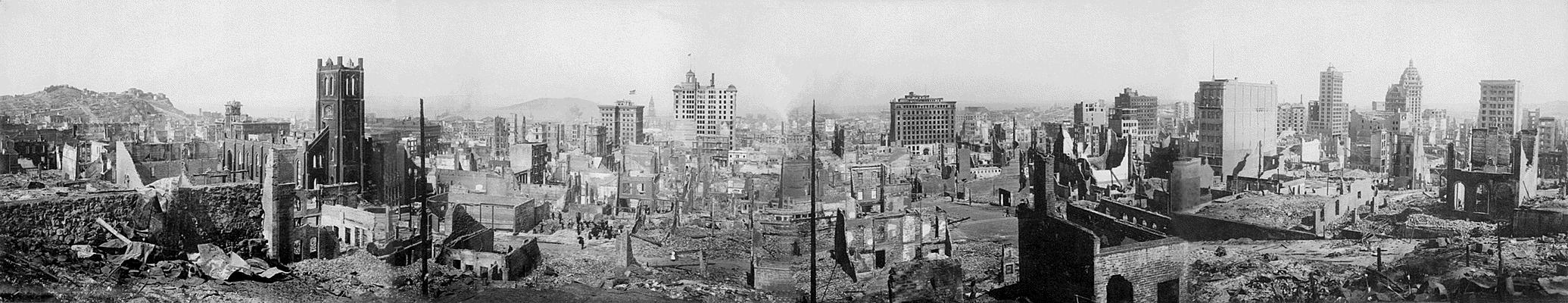
English: San Francisco earthquake 1906 - panoramic view
View of the destruction brought about by the San Francisco Earthquake, 1906 Records of the Office of the Chief Signal Officer (Army) (111-AGF-1-A-D) This is a composite panorama, meaning that it is pieced together from four separate images to give a panoramic effect. The photographer is unknown, though it may have been taken by the Army Signal Corps. It is printed on silver gelatin paper. The photo was taken from the site of the Stanford Mansion, later the Stanford Court hotel, on Powell Street, between California St. and Pine St. The square bell tower in the left frame is that of: Old Saint Mary's Church, 660 California, San Francisco, CA 94108 |
| Date | |
| Source |
National Archives and Records Administration Uploaded from : www.archives.gov |
| Author | Unknown author |
| Camera location | | View this and other nearby images on: OpenStreetMap |
|---|
This work is in the public domain in the United States because it is a work prepared by an officer or employee of the United States Government as part of that person’s official duties under the terms of Title 17, Chapter 1, Section 105 of the US Code.
Note: This only applies to original works of the Federal Government and not to the work of any individual U.S. state, territory, commonwealth, county, municipality, or any other subdivision. This template also does not apply to postage stamp designs published by the United States Postal Service since 1978. (See § 313.6(C)(1) of Compendium of U.S. Copyright Office Practices). It also does not apply to certain US coins; see The US Mint Terms of Use.
|
 | |
| This file has been identified as being free of known restrictions under copyright law, including all related and neighboring rights. | ||
File history
Click on a date/time to view the file as it appeared at that time.
| Date/Time | Thumbnail | Dimensions | User | Comment | |
|---|---|---|---|---|---|
| current | 14:50, 22 June 2005 | 2,071 × 400 (315 KB) | JoJan | San Francisco earthquake 1906 - panoramic view {{USGov-PD}} Uploaded from : [http://www.archives.gov/exhibit_hall/panoramic_photography/images/san_fran_earthquake.html] Credits : National Archives and Records Administration |
File usage
Global file usage
The following other wikis use this file:
- Usage on cs.wikipedia.org
- Usage on da.wikipedia.org
- Usage on de.wikipedia.org
- Usage on et.wikipedia.org
- Usage on frr.wikipedia.org
- Usage on fr.wikipedia.org
- Usage on ga.wikipedia.org
- Usage on gd.wikipedia.org
- Usage on hu.wikipedia.org
- Usage on hy.wikipedia.org
- Usage on hy.wiktionary.org
- Usage on hyw.wikipedia.org
- Usage on ja.wikipedia.org
- Usage on la.wikipedia.org
- Usage on lb.wikipedia.org
- Usage on lt.wikipedia.org
- Usage on nds.wikipedia.org
- Usage on nl.wikipedia.org
- Usage on nrm.wikipedia.org
- Usage on pl.wikipedia.org
- Usage on pt.wikipedia.org
- Usage on ro.wikipedia.org
- Usage on sc.wikipedia.org