
File:Samsi Addu.PNG
Size of this preview: 761 × 600 pixels. Other resolutions: 305 × 240 pixels | 609 × 480 pixels | 996 × 785 pixels.
Original file (996 × 785 pixels, file size: 1.08 MB, MIME type: image/png)
| This is a file from the Wikimedia Commons. Information from its description page there is shown below. Commons is a freely licensed media file repository. You can help. |
| Description |
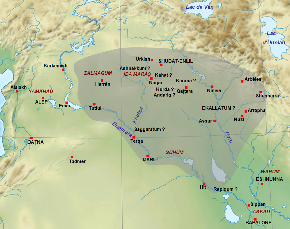
English: Map of the approximate extension of the kingdom of Samsi-Addu/Shamshi-Adad (1815-1775 BC) just before his death, with the territories given to his sons Ishme-Dagan (around Ekallatum) and Yasmakh-Addu (around Mari). The names of cities in capitals letters are the capitals of the main kingdoms of the Middle East at this time. The names of cities with question mark are for uncertain locations. Adapted from F. Joannès (dir.), Dictionnaire de la civilisation mésopotamienne, Paris, 2001, p. 751 (map by M. Sauvage) and D. Charpin, Hammu-rabi de Babylone, Paris, 2003, p. 306. Français : Carte de l'extension approximative du royaume de Samsi-Addu/Shamshi-Adad (1815-1775 av. J.-C.) juste avant sa mort, avec les territoires attribués à ses fils Ishme-Dagan (atour d'Ekallatum) et Yasmakh-Addu (autour de Mari). Les noms de villes en majuscules indiquent les capitales des principaux royaumes du Moyen-Orient à cette période. Les noms de villes avec des points d'interrogation indiquent les villes donc la localisation est incertaine. Adapté de F. Joannès (dir.), Dictionnaire de la civilisation mésopotamienne, Paris, 2001, p. 751 (carte de M. Sauvage) et de D. Charpin, Hammu-rabi de Babylone, Paris, 2003, p. 306. |
| Date | (UTC) |
| Source | |
| Author |
|
| This is a retouched picture, which means that it has been digitally altered from its original version. Modifications: Ajout de l'extension du royaume de Samsi-Addu, des noms de villes et de certaines régions.. The original can be viewed here: Near East topographic map-blank.svg:
|
I, the copyright holder of this work, hereby publish it under the following licenses:
This file is licensed under the Creative Commons Attribution-Share Alike 3.0 Unported, 2.5 Generic, 2.0 Generic and 1.0 Generic license.
- You are free:
- to share – to copy, distribute and transmit the work
- to remix – to adapt the work
- Under the following conditions:
- attribution – You must give appropriate credit, provide a link to the license, and indicate if changes were made. You may do so in any reasonable manner, but not in any way that suggests the licensor endorses you or your use.
- share alike – If you remix, transform, or build upon the material, you must distribute your contributions under the same or compatible license as the original.

|
Permission is granted to copy, distribute and/or modify this document under the terms of the GNU Free Documentation License, Version 1.2 or any later version published by the Free Software Foundation; with no Invariant Sections, no Front-Cover Texts, and no Back-Cover Texts. A copy of the license is included in the section entitled GNU Free Documentation License. |
You may select the license of your choice.
Original upload log
This image is a derivative work of the following images:
- File:Near_East_topographic_map-blank.svg licensed with Cc-by-sa-3.0,2.5,2.0,1.0, GFDL
- 2009-08-18T18:31:37Z Sémhur 2425x1581 (2442670 Bytes) 3 - New try
- 2009-08-17T15:39:22Z Sémhur 2425x1581 (1815374 Bytes) 2 - With the background...
- 2009-08-17T15:37:36Z Sémhur 2425x1581 (2836 Bytes) {{Information |Description={{en|1=Blank physical map of the [[:en:Near East|Near East]]}} {{fr|1=Carte physique vierge du [[:fr:Proche-Orient|Proche-Orient]].}} |Source={{own}} |Author=[[User:Sémhur|Sémhur]] |Date=2008-08-1
Uploaded with derivativeFX
File history
Click on a date/time to view the file as it appeared at that time.
| Date/Time | Thumbnail | Dimensions | User | Comment | |
|---|---|---|---|---|---|
| current | 10:25, 28 September 2010 | | 996 × 785 (1.08 MB) | Zunkir | {{Information |Description={{en|1=Map of the approximate extension of the kingdom of Samsi-Addu/Shamshi-Adad (1815-1775 BC) just before his death, with the territories given to his sons Ishme-Dagan (around Ekallatum) and Yasmakh-Addu (around Mari). The na |
File usage
The following pages on the English Wikipedia use this file (pages on other projects are not listed):
Global file usage
The following other wikis use this file:
- Usage on am.wikipedia.org
- Usage on ar.wikipedia.org
- Usage on arz.wikipedia.org
- Usage on ba.wikipedia.org
- Usage on bn.wikipedia.org
- Usage on br.wikipedia.org
- Usage on ca.wikipedia.org
- Usage on cs.wikipedia.org
- Usage on de.wikipedia.org
- Usage on es.wikipedia.org
- Usage on fa.wikipedia.org
- Usage on fi.wikipedia.org
- Usage on fr.wikipedia.org
- Usage on he.wikipedia.org
- Usage on hi.wikipedia.org
- Usage on id.wikipedia.org
- Usage on it.wikipedia.org
View more global usage of this file.