
File:Salt-diapir-Cape-Breton 022.JPG

Size of this preview: 800 × 533 pixels. Other resolutions: 320 × 213 pixels | 640 × 427 pixels | 1,024 × 683 pixels | 1,280 × 853 pixels | 2,560 × 1,707 pixels | 3,456 × 2,304 pixels.
Original file (3,456 × 2,304 pixels, file size: 3.43 MB, MIME type: image/jpeg)
| This is a file from the Wikimedia Commons. Information from its description page there is shown below. Commons is a freely licensed media file repository. You can help. |
Summary
| Description |
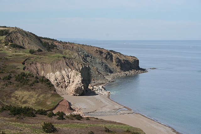
English: Gypsum and anhydrite cap atop the Coal Mine Point salt diapir near Mabou Mines, Nova Scotia. The diapir is sourced in the Windsor Group (Mississippian) and deforms the overlying coal-bearing strata of the Inverness Formation (Pennsylvanian). |
| Date | |
| Source | Own work |
| Author | Michael C. Rygel |
| Permission (Reusing this file) |
Please place my name (Michael C. Rygel) or user name (Rygel, M.C.) in a legible, clearly visible position near one of the corners of the image or in the caption if this image is used outside of Wikipedia of Wikimedia Commons. |
| Camera location | | View this and other nearby images on: OpenStreetMap |
|---|
Licensing
I, the copyright holder of this work, hereby publish it under the following license:
This file is licensed under the Creative Commons Attribution-Share Alike 3.0 Unported license.
- You are free:
- to share – to copy, distribute and transmit the work
- to remix – to adapt the work
- Under the following conditions:
- attribution – You must give appropriate credit, provide a link to the license, and indicate if changes were made. You may do so in any reasonable manner, but not in any way that suggests the licensor endorses you or your use.
- share alike – If you remix, transform, or build upon the material, you must distribute your contributions under the same or compatible license as the original.
File history
Click on a date/time to view the file as it appeared at that time.
| Date/Time | Thumbnail | Dimensions | User | Comment | |
|---|---|---|---|---|---|
| current | 19:42, 5 January 2011 | | 3,456 × 2,304 (3.43 MB) | Rygel, M.C. | {{Information |Description={{en|1=Gypsum and anhydrite cap atop a Windsor Group (Mississippian) salt diapir that has deformed the overlying coal-bearing strata of the Inverness Formation (Pennsylvanian) near Mabou M |
File usage
The following pages on the English Wikipedia use this file (pages on other projects are not listed):
Global file usage
The following other wikis use this file:
- Usage on bn.wikipedia.org
- Usage on de.wikipedia.org