
File:SCXY Map.png

Original file (693 × 868 pixels, file size: 9 KB, MIME type: image/png)
| This is a file from the Wikimedia Commons. Information from its description page there is shown below. Commons is a freely licensed media file repository. You can help. |
Summary
| Description |
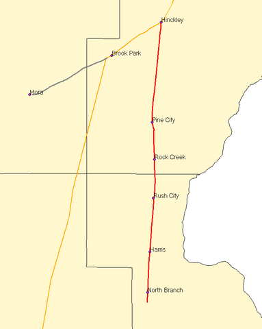
English: Map of the St. Croix Valley Railroad. Red lines are SCXY trackage; the orange lines are BNSF Railway trackage. |
| Date | 3 September 2006 (original upload date) |
| Source | Own work |
| Author | User:Elkman |
Created with Quantum GIS using data from the MNDOT Railroad basemap. The disclaimer on their site says: The Minnesota Department of Transportation makes no representation or warranties, express or implied, with respect to the reuse of data provided herewith, regardless of its format or the means of its transmission. There is no guarantee or representation to the user as to the accuracy, currency, suitability, or reliability of this data for any purpose. The user accepts the data 'as is', and assumes all risks associated with its use. By accepting this data, the user agrees not to transmit this data or provide access to it or any part of it to another party unless the user shall include with the data a copy of this disclaimer. The Minnesota Department of Transportation assumes no responsibility for actual or consequential damage incurred as a result of any user's reliance on this data.
Licensing
| This file is licensed under the Creative Commons Attribution-Share Alike 3.0 Unported license. Subject to disclaimers. | ||
| Attribution: User:Elkman | ||
| ||
| This licensing tag was added to this file as part of the GFDL licensing update. |

|
Permission is granted to copy, distribute and/or modify this document under the terms of the GNU Free Documentation License, Version 1.2 or any later version published by the Free Software Foundation; with no Invariant Sections, no Front-Cover Texts, and no Back-Cover Texts. A copy of the license is included in the section entitled GNU Free Documentation License. Subject to disclaimers. |
- You are free:
- to share – to copy, distribute and transmit the work
- to remix – to adapt the work
- Under the following conditions:
- attribution – You must give appropriate credit, provide a link to the license, and indicate if changes were made. You may do so in any reasonable manner, but not in any way that suggests the licensor endorses you or your use.
- share alike – If you remix, transform, or build upon the material, you must distribute your contributions under the same or compatible license as the original.
Original upload log
Transferred from en.wikipedia to Commons using For the Common Good.
| Date/Time | Dimensions | User | Comment |
|---|---|---|---|
| 18:46, 21 September 2010 | 693 × 868 (8,968 bytes) | w:en:Mulad (talk | contribs) | (Update to show former trackage in gray.) |
| 04:06, 3 September 2006 | 693 × 868 (9,881 bytes) | w:en:Elkman (talk | contribs) | (Map of the [[St. Croix Valley Railroad]]. Red lines are SCXY trackage; the orange lines are [[BNSF Railway]] trackage. Created with Quantum GIS using data from the [http://www.dot.state.mn.us/tda/basemap/metadata/Railroad.htm MNDOT Railroad basemap]. T) |
File history
Click on a date/time to view the file as it appeared at that time.
| Date/Time | Thumbnail | Dimensions | User | Comment | |
|---|---|---|---|---|---|
| current | 02:12, 19 June 2013 | | 693 × 868 (9 KB) | OgreBot | (BOT): Reverting to most recent version before archival |
| 02:12, 19 June 2013 |  | 693 × 868 (10 KB) | OgreBot | (BOT): Uploading old version of file from en.wikipedia; originally uploaded on 2006-09-03 04:06:02 by Elkman | |
| 13:44, 11 June 2013 |  | 693 × 868 (9 KB) | Fredlyfish4 | Transferred from en.wikipedia: see original upload log above |
File usage
Global file usage
The following other wikis use this file:
- Usage on de.wikipedia.org
- Usage on www.wikidata.org