
File:Ryknild street.jpg
No higher resolution available.
Ryknild_street.jpg (640 × 480 pixels, file size: 175 KB, MIME type: image/jpeg)
| This is a file from the Wikimedia Commons. Information from its description page there is shown below. Commons is a freely licensed media file repository. You can help. |
| Description |
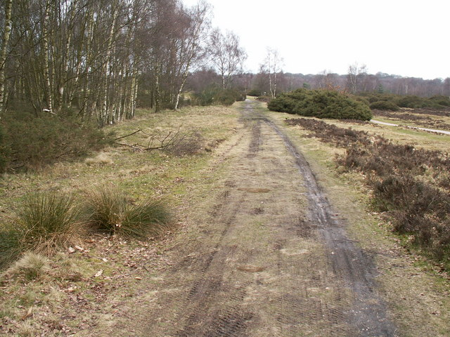
Ryknild Street Roman Road, Sutton Park. Ryknild Street Roman Road, Sutton Park Looking north east. The 1.5 mile section of the Roman road that runs through Sutton Park is one of the best preserved in the country, clearly showing the constructional features typical of roads in this part of the empire. This section of road linked the forts at Metcley (Birmingham) and Wall near Lichfield. |
| Date | |
| Source | From geograph.org.uk |
| Author | Phil Champion |
| Permission (Reusing this file) |
Creative Commons Attribution Share-alike license 2.0 |
| Camera location | | View this and other nearby images on: OpenStreetMap |
|---|

|
This image was taken from the Geograph project collection. See this photograph's page on the Geograph website for the photographer's contact details. The copyright on this image is owned by Phil Champion and is licensed for reuse under the Creative Commons Attribution-ShareAlike 2.0 license.
|
This file is licensed under the Creative Commons Attribution-Share Alike 2.0 Generic license.
Attribution: Phil Champion
- You are free:
- to share – to copy, distribute and transmit the work
- to remix – to adapt the work
- Under the following conditions:
- attribution – You must give appropriate credit, provide a link to the license, and indicate if changes were made. You may do so in any reasonable manner, but not in any way that suggests the licensor endorses you or your use.
- share alike – If you remix, transform, or build upon the material, you must distribute your contributions under the same or compatible license as the original.
File history
Click on a date/time to view the file as it appeared at that time.
| Date/Time | Thumbnail | Dimensions | User | Comment | |
|---|---|---|---|---|---|
| current | 13:53, 31 December 2008 | | 640 × 480 (175 KB) | Victuallers | {{Information |Description=Ryknild Street Roman Road, Sutton Park. Ryknild Street Roman Road, Sutton Park Looking north east. The 1.5 mile section of the Roman road that runs through Sutton Park is one of the best preserved in the co |
File usage
The following pages on the English Wikipedia use this file (pages on other projects are not listed):
Global file usage
The following other wikis use this file:
- Usage on be-tarask.wikipedia.org
- Usage on ca.wikipedia.org
- Usage on cs.wikipedia.org
- Usage on es.wikipedia.org
- Usage on fi.wikipedia.org
- Usage on fr.wikipedia.org
- Usage on it.wikipedia.org
- Usage on la.wikipedia.org
- Usage on no.wikipedia.org
- Usage on pt.wikipedia.org
- Usage on ru.wikipedia.org
- Usage on simple.wikipedia.org
- Usage on www.wikidata.org