
File:Rushton Triangular Lodge.jpg
Size of this preview: 402 × 600 pixels. Other resolutions: 161 × 240 pixels | 429 × 640 pixels.
Original file (429 × 640 pixels, file size: 96 KB, MIME type: image/jpeg)
| This is a file from the Wikimedia Commons. Information from its description page there is shown below. Commons is a freely licensed media file repository. You can help. |
| Description |
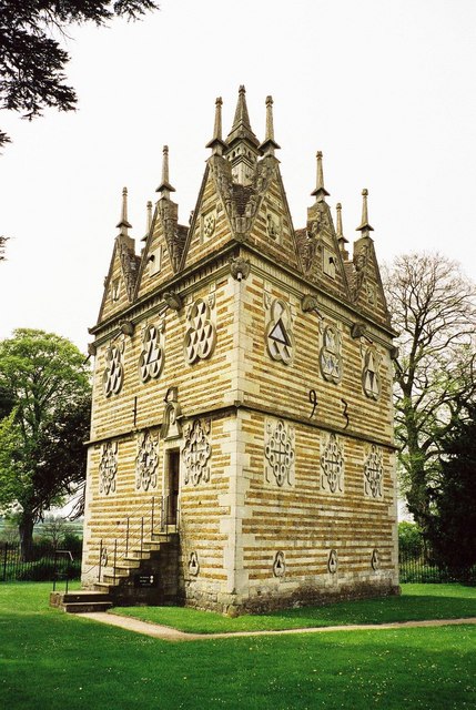
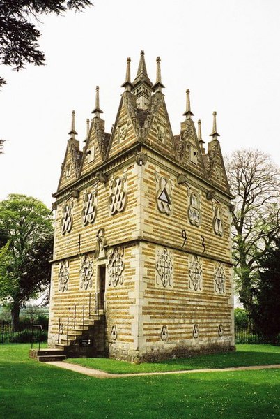
English: Rushton Triangular Lodge, Northamptonshire, England. Everything here has to do with the number 3. The building is 3-sided, each with 3 windows and 3 gables (triangular of course), and an inscription of 33 letters measuring 33 feet in length. It is a 3-storey building and is topped by a 3-sided chimney. It was built by a man with a name suggesting the number 3 – Sir Thomas Tresham – between 28 July 1594 and 29 September 1597 and it symbolises the Holy Trinity. Tresham's coat of arms consists of three trefoils.
|
|
| Date | ||
| Source | see below | |
| Author | Chris Downer | |
| Other versions |
 |
| Camera location | | View this and other nearby images on: OpenStreetMap |
|---|
| Object location | | View this and other nearby images on: OpenStreetMap |
|---|
_region:GB-ENG_heading:225.00&language=en)

|
This image was taken from the Geograph project collection. See this photograph's page on the Geograph website for the photographer's contact details. The copyright on this image is owned by Chris Downer and is licensed for reuse under the Creative Commons Attribution-ShareAlike 2.0 license.
|
This file is licensed under the Creative Commons Attribution-Share Alike 2.0 Generic license.
Attribution: Chris Downer
- You are free:
- to share – to copy, distribute and transmit the work
- to remix – to adapt the work
- Under the following conditions:
- attribution – You must give appropriate credit, provide a link to the license, and indicate if changes were made. You may do so in any reasonable manner, but not in any way that suggests the licensor endorses you or your use.
- share alike – If you remix, transform, or build upon the material, you must distribute your contributions under the same or compatible license as the original.
File history
Click on a date/time to view the file as it appeared at that time.
| Date/Time | Thumbnail | Dimensions | User | Comment | |
|---|---|---|---|---|---|
| current | 21:46, 24 August 2007 | | 429 × 640 (96 KB) | Bjh21 | {{Information |Description=w:Rushton Triangular Lodge, Northamptonshire, England |Source=Geograph British Isles |Date=Tuesday, 4 May, 1999 |Author=Chris Downer |Permission=© Copyright Chris Downer and licensed for reuse under this Creative Commons L |
File usage
The following pages on the English Wikipedia use this file (pages on other projects are not listed):
Global file usage
The following other wikis use this file:
- Usage on ca.wikipedia.org
- Usage on ceb.wikipedia.org
- Usage on cy.wikipedia.org
- Usage on dag.wikipedia.org
- Usage on de.wikipedia.org
- Usage on fr.wikipedia.org
- Usage on it.wikipedia.org
- Usage on lld.wikipedia.org
- Usage on ru.wikipedia.org
- Usage on uk.wikipedia.org
- Usage on www.wikidata.org