
File:Ruin of Rugeley Old Church - geograph.org.uk - 178883.jpg
No higher resolution available.
Ruin_of_Rugeley_Old_Church_-_geograph.org.uk_-_178883.jpg (640 × 427 pixels, file size: 98 KB, MIME type: image/jpeg)
| This is a file from the Wikimedia Commons. Information from its description page there is shown below. Commons is a freely licensed media file repository. You can help. |
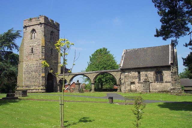
This is a photo of listed building number 1178170. |
Summary
| Description |
English: The remains of the former St Augustine's parish church, Rugeley, Staffordshire, seen from the southwest. Replaced in 1822 by a new church of the same name on the opposite side of the B5013 Colton Road. |
| Date | |
| Source | From geograph.org.uk |
| Author | Geoff Pick |
| Attribution (required by the license) | Geoff Pick / Ruin of Rugeley Old Church / |
| Camera location | | View this and other nearby images on: OpenStreetMap |
|---|
_heading:90.00&language=en)
| Object location | | View this and other nearby images on: OpenStreetMap |
|---|
_heading:90.00&language=en)
Licensing

|
This image was taken from the Geograph project collection. See this photograph's page on the Geograph website for the photographer's contact details. The copyright on this image is owned by Geoff Pick and is licensed for reuse under the Creative Commons Attribution-ShareAlike 2.0 license.
|
This file is licensed under the Creative Commons Attribution-Share Alike 2.0 Generic license.
Attribution: Geoff Pick
- You are free:
- to share – to copy, distribute and transmit the work
- to remix – to adapt the work
- Under the following conditions:
- attribution – You must give appropriate credit, provide a link to the license, and indicate if changes were made. You may do so in any reasonable manner, but not in any way that suggests the licensor endorses you or your use.
- share alike – If you remix, transform, or build upon the material, you must distribute your contributions under the same or compatible license as the original.
File history
Click on a date/time to view the file as it appeared at that time.
| Date/Time | Thumbnail | Dimensions | User | Comment | |
|---|---|---|---|---|---|
| current | 15:16, 31 January 2010 | | 640 × 427 (98 KB) | GeographBot | == {{int:filedesc}} == {{Information |description={{en|1=Ruin of Rugeley Old Church. Dedicated to St. Augustine, this church was replaced by one of the same name in 1822. The new church stands immediately opposite this one on the other side of the B5013.} |
File usage
The following pages on the English Wikipedia use this file (pages on other projects are not listed):