
File:Roman cities Vojvodina.png

Size of this preview: 800 × 536 pixels. Other resolutions: 320 × 214 pixels | 640 × 428 pixels | 1,024 × 686 pixels | 1,280 × 857 pixels | 1,770 × 1,185 pixels.
Original file (1,770 × 1,185 pixels, file size: 140 KB, MIME type: image/png)
| This is a file from the Wikimedia Commons. Information from its description page there is shown below. Commons is a freely licensed media file repository. You can help. |
Summary
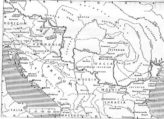
- English: Roman cities and provinces in middle Danube area (2nd century).
- Serbian: Rimski gradovi i provincije u srednjem Podunavlju (2. vek).
Licensing
own work - self made map by user:PANONIAN
| This work has been released into the public domain by its author, PANONIAN. This applies worldwide. In some countries this may not be legally possible; if so: |
References
- Dr Dušan J. Popović, Srbi u Vojvodini, knjiga 1, Novi Sad, 1990.
- Dr Nikola Vulić, Vojvodina u rimsko doba, Zbornik "Vojvodina", knjiga I, PROMETEJ, Novi Sad, 2008.
- Duško Lopandić, Purpur imperije, Beograd, 2007.
- Školski istorijski atlas, Zavod za izdavanje udžbenika SR Srbije, Beograd, 1970.
- Povijesni atlas, Učila - Zagreb, Zagreb, 1971.
- Istorijski atlas, Geokarta, Beograd, 1999.
- Istorijski atlas, Intersistem kartografija, Beograd, 2010.
- Denis Šehić - Demir Šehić, Istorijski atlas sveta, Beograd, 2007.
- Dragan Brujić, Vodič kroz svet antike, Beograd, 2005.
- http://www.melnica.com/slike/mapa_vlasija_topp.jpg
- http://privat.bahnhof.se/wb189452/mapa12.jpg
- http://abuss.narod.ru/Biblio/Maps/map244.gif
- http://upload.moldova.org/map/dacia-sec_ii-iii.jpg archive copy at the Wayback Machine
- http://enciclopedia-dacica.ro/civilizatia_daca/dacia_04.jpg
- http://apulumarchaeology.files.wordpress.com/2010/09/dacia_06.jpg
- http://conflicts.rem33.com/images/Ungarn/pannonia_nagy.jpg
- http://www.croatia-in-english.com/images/maps/3-5cen.jpg
File history
Click on a date/time to view the file as it appeared at that time.
| Date/Time | Thumbnail | Dimensions | User | Comment | |
|---|---|---|---|---|---|
| current | 08:33, 9 January 2014 | | 1,770 × 1,185 (140 KB) | PANONIAN | aesthetics |
| 08:47, 16 October 2011 |  | 1,771 × 1,185 (140 KB) | PANONIAN | some corrections | |
| 21:01, 1 May 2009 |  | 1,791 × 1,197 (140 KB) | PANONIAN | ==Description== Roman cities and provinces in middle Danube area (2nd century) == Licensing == my own work {{PD-user|PANONIAN}} Category:Maps of the history of Vojvodina Category:Maps of the history of Serbia [[Category:Maps of the history of Ro |
File usage
The following pages on the English Wikipedia use this file (pages on other projects are not listed):
Global file usage
The following other wikis use this file:
- Usage on de.wikipedia.org
- Usage on el.wikipedia.org
- Usage on es.wikipedia.org
- Usage on fr.wikipedia.org
- Usage on gl.wikipedia.org
- Usage on ja.wikipedia.org
- Usage on mk.wikipedia.org
- Usage on sh.wikipedia.org
- Usage on sq.wikipedia.org