
File:Rockall EEZ map-en.svg

Size of this PNG preview of this SVG file: 455 × 600 pixels. Other resolutions: 182 × 240 pixels | 364 × 480 pixels | 583 × 768 pixels | 777 × 1,024 pixels | 1,554 × 2,048 pixels | 1,904 × 2,509 pixels.
Original file (SVG file, nominally 1,904 × 2,509 pixels, file size: 577 KB)
| This is a file from the Wikimedia Commons. Information from its description page there is shown below. Commons is a freely licensed media file repository. You can help. |
Summary
| Description |
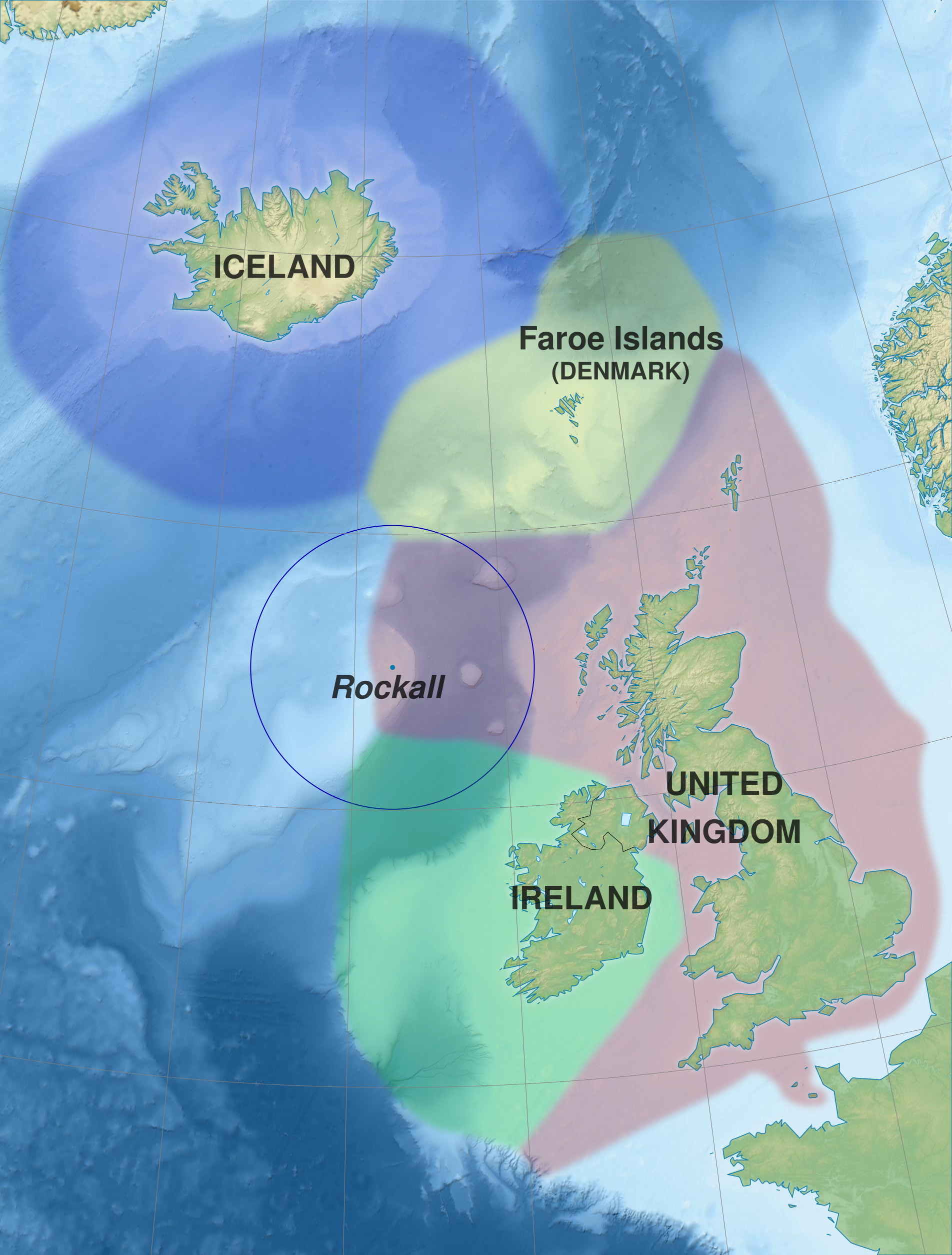
English: Map of exclusive economic zones of the UK, Republic of Ireland, the Faroe Islands (Denmark) and Iceland around Rockall, United Kingdom. Cartographic data :
Français : Carte des zones économiques exclusives du Royaume-Uni, de l'Irlande, des îles Féroé (Danemark) et de l'Islande autour de Rockall (Royaume-Uni). Données cartographiques :
|
||||
| Date | (UTC) | ||||
| Source |
This file was derived from: Rockall EEZ map-fr.svg |
||||
| Author | Sémhur (talk) | ||||
| Permission (Reusing this file) |
|||||
| Attribution (required by the license) | © Sémhur / Wikimedia Commons / | ||||
| SVG | W3C-validity not checked.
|
||||
| Graphic Lab | |||||
| Other versions |
|

| Camera location | | View this and other nearby images on: OpenStreetMap |
|---|
Licensing
I, the copyright holder of this work, hereby publish it under the following licenses:
| Copyleft: This work of art is free; you can redistribute it and/or modify it according to terms of the Free Art License. You will find a specimen of this license on the Copyleft Attitude site as well as on other sites. |
This file is licensed under the Creative Commons Attribution-Share Alike Attribution-Share Alike 4.0 International, 3.0 Unported, 2.5 Generic, 2.0 Generic and 1.0 Generic license.
- You are free:
- to share – to copy, distribute and transmit the work
- to remix – to adapt the work
- Under the following conditions:
- attribution – You must give appropriate credit, provide a link to the license, and indicate if changes were made. You may do so in any reasonable manner, but not in any way that suggests the licensor endorses you or your use.
- share alike – If you remix, transform, or build upon the material, you must distribute your contributions under the same or compatible license as the original.
You may select the license of your choice.
Original upload log
This image is a derivative work of the following images:
- File:Rockall_EEZ_map-fr.svg licensed with Cc-by-sa-3.0,2.5,2.0,1.0, FAL
- 2012-02-20T21:13:22Z Sémhur 512x675 (590717 Bytes) La ZEE des îles Anglo-normandes rejoint celle de la Grande-Bretagne.
- 2012-02-20T20:52:35Z Sémhur 512x675 (590896 Bytes) + Metadata
- 2012-02-20T20:46:34Z Sémhur 512x675 (589169 Bytes) == {{int:filedesc}} == {{Information |Description={{Multilingual description |en= Map of exclusive economic zones around [[:en:Rockall|]], United Kingdom. |fr= Carte des zones économiques exclusives autour de [[:fr:Rockall|]
Uploaded with derivativeFX
File history
Click on a date/time to view the file as it appeared at that time.
| Date/Time | Thumbnail | Dimensions | User | Comment | |
|---|---|---|---|---|---|
| current | 09:52, 30 May 2014 | | 1,904 × 2,509 (577 KB) | Sémhur | Valid SVG |
| 13:32, 21 February 2012 |  | 512 × 675 (577 KB) | Sémhur | == {{int:filedesc}} == {{Information |Description={{Multilingual description |en= Map of exclusive economic zones of the UK, Republic of Ireland, the Faroe Islands (Denmark) and Iceland around Rockall, Uni |
File usage
The following pages on the English Wikipedia use this file (pages on other projects are not listed):
Global file usage
The following other wikis use this file:
- Usage on ast.wikipedia.org
- Usage on da.wikipedia.org
- Usage on eo.wikipedia.org
- Usage on es.wikipedia.org
- Usage on fr.wikipedia.org
- Usage on hu.wikipedia.org
- Usage on ja.wikipedia.org
- Usage on no.wikipedia.org
- Usage on pl.wikipedia.org
- Usage on sv.wikipedia.org
- Usage on szl.wikipedia.org
- Usage on tr.wikipedia.org
- Usage on zh.wikipedia.org