
File:Rochester and Eastern Rapid Railway Map.gif

Size of this preview: 800 × 395 pixels. Other resolutions: 320 × 158 pixels | 640 × 316 pixels | 1,296 × 640 pixels.
Original file (1,296 × 640 pixels, file size: 95 KB, MIME type: image/gif)
| This is a file from the Wikimedia Commons. Information from its description page there is shown below. Commons is a freely licensed media file repository. You can help. |
Summary
| Description |
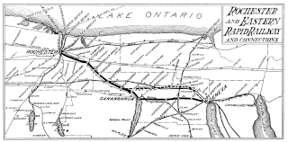
English: Map of the Rochester & Eastern Rapid Railway, which connected Rochester and Canandaigua, N.Y., from 1901-1930. |
| Date | |
| Source | http://www.rochesterandeastern.com/ |
| Author | Rochester & Eastern Rapid Railway |
Licensing
This file is in the public domain because This is a map of the railroad in question. The company is defunct and there is no claim on copyright.
|
File history
Click on a date/time to view the file as it appeared at that time.
| Date/Time | Thumbnail | Dimensions | User | Comment | |
|---|---|---|---|---|---|
| current | 04:17, 9 July 2014 | | 1,296 × 640 (95 KB) | NightWriter77 | Uploading a public-domain item using File Upload Wizard |
File usage
The following pages on the English Wikipedia use this file (pages on other projects are not listed):