
File:Riverside Raceway.JPG
No higher resolution available.
Riverside_Raceway.JPG (403 × 510 pixels, file size: 326 KB, MIME type: image/jpeg)
| This is a file from the Wikimedia Commons. Information from its description page there is shown below. Commons is a freely licensed media file repository. You can help. |
Summary
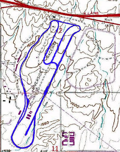
| Description | The 1969 to 1989 version of en:Riverside International Raceway in en:Riverside, California, the track diagram is in blue from using Adobe Photoshop. Image courtesy of the USGS. |
| Source | USGS and the track diagram is in blue from using Adobe Photoshop |
| Author | USGS and TVSRR |


Licensing
This image is in the public domain in the United States because it only contains materials that originally came from the United States Geological Survey, an agency of the United States Department of the Interior. For more information, see the official USGS copyright policy.
|
Original upload log
The original description page was here. All following user names refer to en.wikipedia.
- 2006-03-01 04:04 TVSRR 403×510×8 (333758 bytes) The 1969 to 1989 version of [[Riverside International Raceway]] in [[Riverside, California]], the track is in blue from using Adobe Photoshop. Image courtesy of the USGS
- 2005-04-10 03:34 TVSRR 740×286×8 (21712 bytes) Update of Riverside Raceway (1969 to 1989 verson). Skecth by Jason Trew
- 2005-04-10 03:17 TVSRR 740×286×8 (13359 bytes) Riverside Raceway (1969 to 1989 verson) under a rough skech through MS paint. Jason Trew sketch
File history
Click on a date/time to view the file as it appeared at that time.
| Date/Time | Thumbnail | Dimensions | User | Comment | |
|---|---|---|---|---|---|
| current | 09:26, 4 September 2007 | | 403 × 510 (326 KB) | Liftarn | {{Information |Description=The 1969 to 1989 version of en:Riverside International Raceway in en:Riverside, California, the track diagram is in blue from using Adobe Photoshop. Image courtesy of the USGS. |Source=Originally from [http://en.wikipe |
File usage
The following pages on the English Wikipedia use this file (pages on other projects are not listed):
- 1969 Motor Trend 500
- 1970 Motor Trend 500
- 1971 Motor Trend 500
- 1973 Tuborg 400
- 1973 Winston Western 500
- 1975 Winston Western 500
- 1976 Riverside 400
- 1980 Warner W. Hodgdon 400
- 1981 Winston Western 500 (January)
- 1981 Winston Western 500 (November)
- 1982 Winston Western 500
- 1983 Winston Western 500
- 1985 Winston Western 500
- History of Riverside, California
- Moreno Valley, California
- Riverside International Automotive Museum
- Road racing
- Talk:Race track
Global file usage
The following other wikis use this file:
- Usage on de.wikipedia.org
- Usage on eo.wikipedia.org
- Usage on es.wikipedia.org
- Usage on fr.wikipedia.org
- Usage on it.wikipedia.org
- Usage on ja.wikipedia.org
- Usage on no.wikipedia.org