
File:Ricketts Glen State Park Map.png
Size of this preview: 778 × 599 pixels. Other resolutions: 312 × 240 pixels | 623 × 480 pixels | 997 × 768 pixels | 1,280 × 986 pixels | 1,676 × 1,291 pixels.
Original file (1,676 × 1,291 pixels, file size: 128 KB, MIME type: image/png)
| This is a file from the Wikimedia Commons. Information from its description page there is shown below. Commons is a freely licensed media file repository. You can help. |
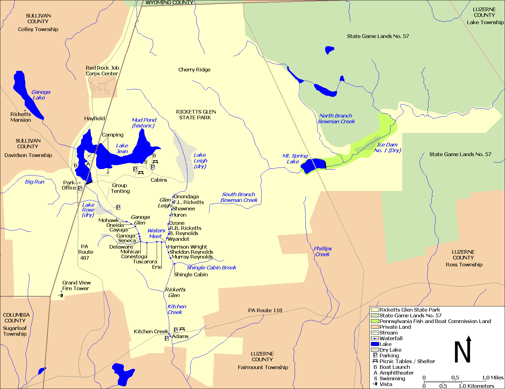
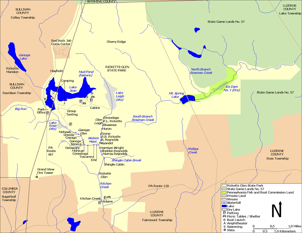
| Description | Map of Ricketts Glen State Park, in Columbia, Luzerne, and Sullivan Counties, Pennsylvania, USA |
| Date | |
| Source | water, roads, some park boundaries taken from US Census website [1] and modified by User:Ruhrfisch, property boundaries based on this PennDOT map and the following map, facilities based on this PA DCNR map. |
| Author | US Census, Ruhrfisch |
| Permission (Reusing this file) |
US Census / US Government work is public domain, my modifications licensed under the GNU Free Documentation License |
Note: Color scheme - ivory is Ricketts Glen State Park, light green is State Game Lands, bright green is Pennsylvania Fish and Boat Commission land, and brown is private land.
Licensing
I, Ruhrfisch, the copyright holder of this work, hereby publishes it under the following licenses:

|
Permission is granted to copy, distribute and/or modify this document under the terms of the GNU Free Documentation License, Version 1.2 or any later version published by the Free Software Foundation; with no Invariant Sections, no Front-Cover Texts, and no Back-Cover Texts. A copy of the license is included in the section entitled GNU Free Documentation License. |
| This file is licensed under the Creative Commons Attribution-Share Alike 3.0 Unported license. | ||
| Attribution: I, Ruhrfisch | ||
| ||
| This licensing tag was added to this file as part of the GFDL licensing update. |
You may select the license of your choice.
and
This image or file is a work of a United States Census Bureau employee, taken or made as part of that person's official duties. As a work of the U.S. federal government, the image is in the public domain.
|
 |
File history
Click on a date/time to view the file as it appeared at that time.
| Date/Time | Thumbnail | Dimensions | User | Comment | |
|---|---|---|---|---|---|
| current | 15:16, 22 July 2010 | | 1,676 × 1,291 (128 KB) | Ruhrfisch | Add labels for Cherry Ridge, Hayfield, Ricketts Mansion - all other information is the same |
| 20:27, 7 April 2010 |  | 1,676 × 1,291 (127 KB) | Ruhrfisch | Change colors to avoid so much yellow | |
| 22:41, 1 April 2010 |  | 1,676 × 1,291 (127 KB) | Ruhrfisch | {{Information| |Description= Map of {{w|Ricketts Glen State Park}}, in Columbia, Luzerne, and Sullivan Counties, Pennsylvania, USA |Source= water, roads, some park boundaries taken from US Census website [http://factfinder.census.gov/] and modified by [ |
File usage
The following pages on the English Wikipedia use this file (pages on other projects are not listed):