
File:Resettlement of Circassians Into Ottoman Empire.jpg
Size of this preview: 800 × 426 pixels. Other resolutions: 320 × 171 pixels | 640 × 341 pixels | 1,199 × 639 pixels.
Original file (1,199 × 639 pixels, file size: 420 KB, MIME type: image/jpeg)
| This is a file from the Wikimedia Commons. Information from its description page there is shown below. Commons is a freely licensed media file repository. You can help. |

|
This map image could be re-created using vector graphics as an SVG file. This has several advantages; see Commons:Media for cleanup for more information. If an SVG form of this image is available, please upload it and afterwards replace this template with
{{vector version available|new image name}}.
It is recommended to name the SVG file “Resettlement of Circassians Into Ottoman Empire.svg”—then the template Vector version available (or Vva) does not need the new image name parameter. |


Summary
| Description |
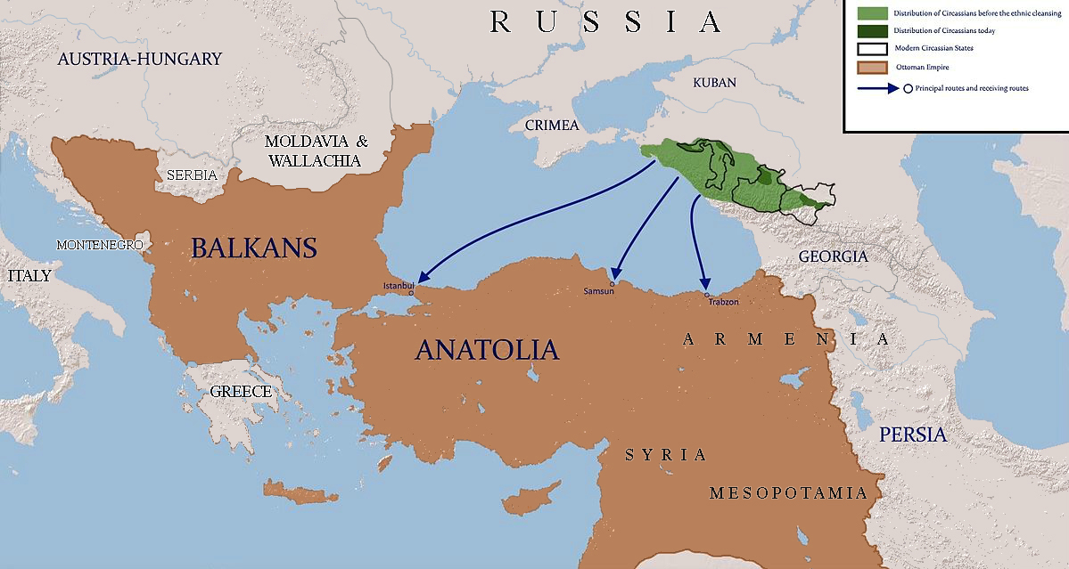
English: map shows the routes which were used to resettle circassians to ottoman empire |
| Date | |
| Source | using paint.net |
| Author | Ercwlff |
| Other versions |
 |
Licensing
I, the copyright holder of this work, hereby publish it under the following licenses:

|
Permission is granted to copy, distribute and/or modify this document under the terms of the GNU Free Documentation License, Version 1.2 or any later version published by the Free Software Foundation; with no Invariant Sections, no Front-Cover Texts, and no Back-Cover Texts. A copy of the license is included in the section entitled GNU Free Documentation License. |
This file is licensed under the Creative Commons Attribution-Share Alike 3.0 Unported license.
- You are free:
- to share – to copy, distribute and transmit the work
- to remix – to adapt the work
- Under the following conditions:
- attribution – You must give appropriate credit, provide a link to the license, and indicate if changes were made. You may do so in any reasonable manner, but not in any way that suggests the licensor endorses you or your use.
- share alike – If you remix, transform, or build upon the material, you must distribute your contributions under the same or compatible license as the original.
You may select the license of your choice.
|
|
This historical map image could be re-created using vector graphics as an SVG file. This has several advantages; see Commons:Media for cleanup for more information. If an SVG form of this image is available, please upload it and afterwards replace this template with
{{vector version available|new image name}}.
It is recommended to name the SVG file “Resettlement of Circassians Into Ottoman Empire.svg”—then the template Vector version available (or Vva) does not need the new image name parameter. |
File history
Click on a date/time to view the file as it appeared at that time.
| Date/Time | Thumbnail | Dimensions | User | Comment | |
|---|---|---|---|---|---|
| current | 17:50, 5 April 2021 | | 1,199 × 639 (420 KB) | Claude Zygiel | Ottoman borders 1864-67 during the Circassian ressettlement |
| 11:47, 4 October 2020 |  | 1,199 × 639 (421 KB) | Ориенталист | More correct map, Greece is independent, Bessarabia is part of Russia | |
| 09:59, 23 May 2015 |  | 1,782 × 950 (425 KB) | Ercwlff | {{subst:Upload marker added by en.wp UW}} {{Information |Description = {{en|map shows the routes which were used to resettle circassians to ottoman empire}} |Source = using paint.net |Date = 2015-05-23 |Author = IrakliGuna }} |
File usage
The following pages on the English Wikipedia use this file (pages on other projects are not listed):
Global file usage
The following other wikis use this file:
- Usage on ar.wikipedia.org
- Usage on be-tarask.wikipedia.org
- Usage on bn.wikipedia.org
- Usage on et.wikipedia.org
- Usage on fa.wikipedia.org
- Usage on fr.wikipedia.org
- Usage on he.wikipedia.org
- Usage on ja.wikipedia.org
- Usage on ko.wikipedia.org
- Usage on lv.wikipedia.org
- Usage on nl.wikipedia.org
- Usage on no.wikipedia.org
- Usage on pl.wikipedia.org
- Usage on pnb.wikipedia.org
- Usage on ru.wikipedia.org
- Usage on sl.wikipedia.org
- Usage on sr.wikipedia.org
- Usage on ur.wikipedia.org