
File:Reedham Chain Ferry, Norfolk - geograph.org.uk - 498123.jpg
No higher resolution available.
Reedham_Chain_Ferry,_Norfolk_-_geograph.org.uk_-_498123.jpg (640 × 427 pixels, file size: 87 KB, MIME type: image/jpeg)
| This is a file from the Wikimedia Commons. Information from its description page there is shown below. Commons is a freely licensed media file repository. You can help. |
Summary
| Description |
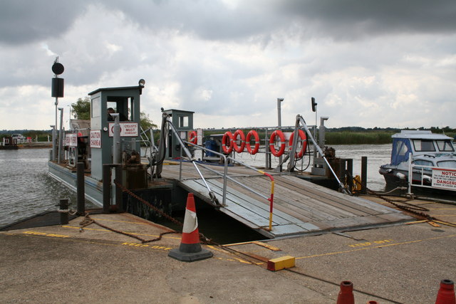
English: Reedham Chain Ferry, Norfolk I suppose we should be very grateful that this ferry still operates at all, since so many have been withdrawn, but it is expensive. The River Yare is some 50 metres wide here, and if the airlines charged the same rate per mile as Norfolk County Council charges for this ferry, it would cost £1.6 million to fly to Australia - and that's just the single fare! |
| Date | |
| Source | From geograph.org.uk |
| Author | Dr Neil Clifton |
| Attribution (required by the license) | Dr Neil Clifton / Reedham Chain Ferry, Norfolk / |
| Camera location | | View this and other nearby images on: OpenStreetMap |
|---|
_heading:157.00&language=en)
| Object location | | View this and other nearby images on: OpenStreetMap |
|---|
_heading:157.00&language=en)
Licensing

|
This image was taken from the Geograph project collection. See this photograph's page on the Geograph website for the photographer's contact details. The copyright on this image is owned by Dr Neil Clifton and is licensed for reuse under the Creative Commons Attribution-ShareAlike 2.0 license.
|
This file is licensed under the Creative Commons Attribution-Share Alike 2.0 Generic license.
Attribution: Dr Neil Clifton
- You are free:
- to share – to copy, distribute and transmit the work
- to remix – to adapt the work
- Under the following conditions:
- attribution – You must give appropriate credit, provide a link to the license, and indicate if changes were made. You may do so in any reasonable manner, but not in any way that suggests the licensor endorses you or your use.
- share alike – If you remix, transform, or build upon the material, you must distribute your contributions under the same or compatible license as the original.
File history
Click on a date/time to view the file as it appeared at that time.
| Date/Time | Thumbnail | Dimensions | User | Comment | |
|---|---|---|---|---|---|
| current | 05:49, 5 February 2011 | | 640 × 427 (87 KB) | GeographBot | == {{int:filedesc}} == {{Information |description={{en|1=Reedham Chain Ferry, Norfolk I suppose we should be very grateful that this ferry still operates at all, since so many have been withdrawn, but it is expensive. The River Yare is some 50 metres wide |
File usage
The following pages on the English Wikipedia use this file (pages on other projects are not listed):
Global file usage
The following other wikis use this file:
- Usage on de.wikipedia.org
- Usage on no.wikipedia.org
- Usage on www.wikidata.org