
File:Ray Roberts Lake Texas.jpg

Size of this preview: 800 × 533 pixels. Other resolutions: 320 × 213 pixels | 640 × 427 pixels | 1,024 × 683 pixels | 1,500 × 1,000 pixels.
Original file (1,500 × 1,000 pixels, file size: 174 KB, MIME type: image/jpeg)
| This is a file from the Wikimedia Commons. Information from its description page there is shown below. Commons is a freely licensed media file repository. You can help. |
| Description |
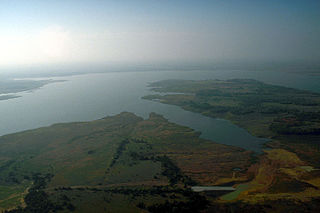
English: Aerial view of Ray Roberts Lake on the Elm Fork of the Trinity River in Denton County, Texas, USA. The dam, visible in the distance, is over 2 miles (3.2 km) long. The lake also backs up into Cooke and Grayson Counties. The U.S. Army Corps of Engineers constructed the dam in 1987 to provide water supply for the cities of Denton and Dallas. View is to the north.
Coordinates: 33°22′11″N 97°03′23″W / 33.36972°N 97.05639°W |
|||
| Location | Denton County, Texas, USA | |||
| Date | not specified or unknown | |||
| Source |
U.S. Army Corps of Engineers Digital Visual Library Image page Image description page Digital Visual Library home page |
|||
| Author | U.S. Army Corps of Engineers, photographer not specified or unknown | |||
| Permission (Reusing this file) |
|
File history
Click on a date/time to view the file as it appeared at that time.
| Date/Time | Thumbnail | Dimensions | User | Comment | |
|---|---|---|---|---|---|
| current | 17:37, 19 May 2007 | | 1,500 × 1,000 (174 KB) | DanMS | {{Information | Description = {{en|Aerial view of Ray Roberts Lake on the Elm Fork in Denton County, Texas, USA. The dam, visiblie in the distance, is over 2 miles (3.2 km) long. The lake also backs up into Cooke and Grayson Counties. The U.S. Army Cor |
File usage
The following pages on the English Wikipedia use this file (pages on other projects are not listed):
Global file usage
The following other wikis use this file:
- Usage on es.wikipedia.org
- Usage on www.wikidata.org