
File:Radio Interferometer - geograph.org.uk - 1234208.jpg
No higher resolution available.
Radio_Interferometer_-_geograph.org.uk_-_1234208.jpg (640 × 440 pixels, file size: 98 KB, MIME type: image/jpeg)
| This is a file from the Wikimedia Commons. Information from its description page there is shown below. Commons is a freely licensed media file repository. You can help. |
Summary
| Description |
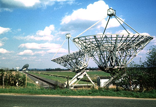
English: Radio Interferometer: These two dishes were part of the Half-Mile Telescope, a radio interferometer utilising the line of an old railway SW of Barton on the Mullard Radio Observatory site of the Cambridge Cavendish Laboratory. In the distance are two more identical dishes, and two large dishes that are part of the One-Mile Telescope. Also visible on the right is the line of elements comprising the 4C Array. |
| Date | |
| Source | From geograph.org.uk |
| Author | Andy Waddington |
| Attribution (required by the license) | Andy Waddington / Radio Interferometer / |
| Camera location | | View this and other nearby images on: OpenStreetMap |
|---|
| Object location | | View this and other nearby images on: OpenStreetMap |
|---|
_heading:90.00&language=en)
Licensing

|
This image was taken from the Geograph project collection. See this photograph's page on the Geograph website for the photographer's contact details. The copyright on this image is owned by Andy Waddington and is licensed for reuse under the Creative Commons Attribution-ShareAlike 2.0 license.
|
This file is licensed under the Creative Commons Attribution-Share Alike 2.0 Generic license.
Attribution: Andy Waddington
- You are free:
- to share – to copy, distribute and transmit the work
- to remix – to adapt the work
- Under the following conditions:
- attribution – You must give appropriate credit, provide a link to the license, and indicate if changes were made. You may do so in any reasonable manner, but not in any way that suggests the licensor endorses you or your use.
- share alike – If you remix, transform, or build upon the material, you must distribute your contributions under the same or compatible license as the original.
File history
Click on a date/time to view the file as it appeared at that time.
| Date/Time | Thumbnail | Dimensions | User | Comment | |
|---|---|---|---|---|---|
| current | 14:03, 26 February 2011 | | 640 × 440 (98 KB) | GeographBot | == {{int:filedesc}} == {{Information |description={{en|1=Radio Interferometer This was the then recently-built radio interferometer utilising the line of an old railway SW of Barton on the Mullard Radio Observatory site of the Cambridge Cavendish Laborato |
File usage
The following pages on the English Wikipedia use this file (pages on other projects are not listed):
Global file usage
The following other wikis use this file:
- Usage on fr.wikipedia.org
- Usage on pt.wikipedia.org
- Usage on www.wikidata.org