
File:Radhanites2.png
Size of this preview: 800 × 400 pixels. Other resolutions: 320 × 160 pixels | 640 × 320 pixels | 1,201 × 601 pixels.
Original file (1,201 × 601 pixels, file size: 1.41 MB, MIME type: image/png)
| This is a file from the Wikimedia Commons. Information from its description page there is shown below. Commons is a freely licensed media file repository. You can help. |
Summary
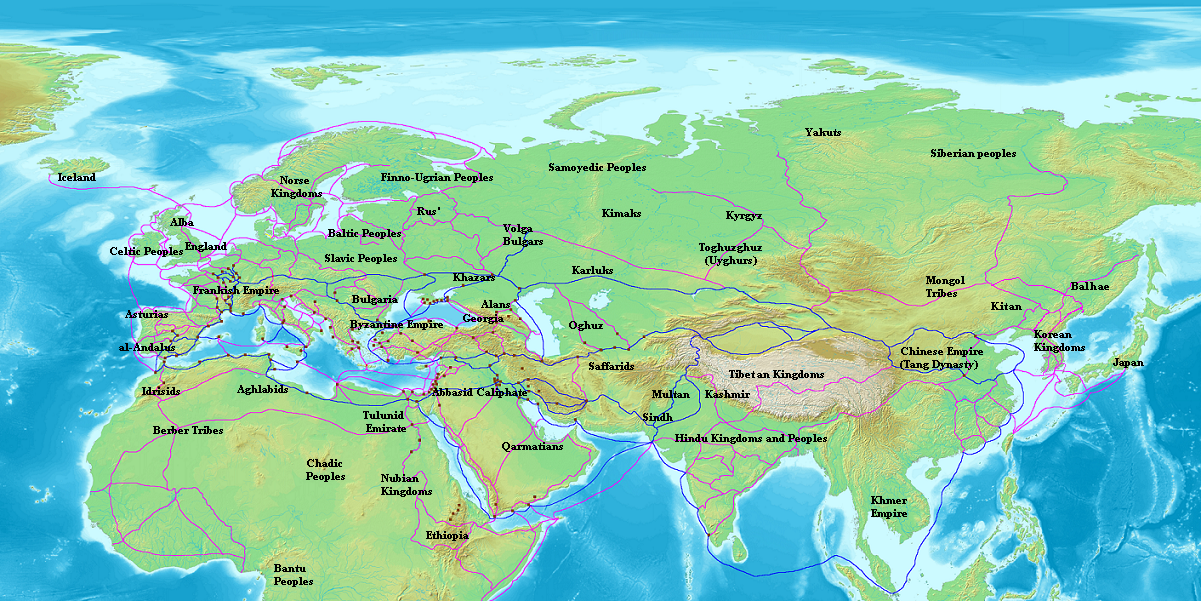
| Description | (Map of Eurasia and North Africa, c. 870 CE. Trade routes of the Radhanite Jewish merchants are shown in blue. Other major trade routes shown in purple. Cities with sizable Jewish communities are shown in brown. Some routes are conjectural.) |
| Source | Own work |
| Author | Briangotts |
Licensing
I, Briangotts, the copyright holder of this work, hereby publishes it under the following licenses:

|
Permission is granted to copy, distribute and/or modify this document under the terms of the GNU Free Documentation License, Version 1.2 or any later version published by the Free Software Foundation; with no Invariant Sections, no Front-Cover Texts, and no Back-Cover Texts. A copy of the license is included in the section entitled GNU Free Documentation License. |
| This file is licensed under the Creative Commons Attribution-Share Alike 3.0 Unported license. | ||
| Attribution: I, Briangotts | ||
| ||
| This licensing tag was added to this file as part of the GFDL licensing update. |
This file is licensed under the Creative Commons Attribution 2.5 Generic license.
Attribution: I, Briangotts
- You are free:
- to share – to copy, distribute and transmit the work
- to remix – to adapt the work
- Under the following conditions:
- attribution – You must give appropriate credit, provide a link to the license, and indicate if changes were made. You may do so in any reasonable manner, but not in any way that suggests the licensor endorses you or your use.
You may select the license of your choice.
File history
Click on a date/time to view the file as it appeared at that time.
| Date/Time | Thumbnail | Dimensions | User | Comment | |
|---|---|---|---|---|---|
| current | 12:34, 27 April 2015 | | 1,201 × 601 (1.41 MB) | Lx 121 | Reverted to version as of 03:46, 19 July 2007; i see no changes, the replacement map is just SMALLER. if anyone can find otherwise,pls revert my revert? |
| 16:09, 8 October 2012 |  | 799 × 403 (675 KB) | Runehelmet | . | |
| 03:46, 19 July 2007 |  | 1,201 × 601 (1.41 MB) | Briangotts | {{Information |Description=(Map of Eurasia and North Africa, c. 870 CE. Trade routes of the Radhanite Jewish merchants are shown in blue. Other major trade routes shown in purple. Cities with sizable Jewish communities are shown in brown. Some routes are |
File usage
The following pages on the English Wikipedia use this file (pages on other projects are not listed):
Global file usage
The following other wikis use this file:
- Usage on ar.wikipedia.org
- Usage on bg.wikipedia.org
- Usage on el.wikipedia.org
- Usage on es.wikipedia.org
- Usage on fa.wikipedia.org
- Usage on fr.wikipedia.org
- Usage on hu.wikipedia.org
- Usage on hy.wikipedia.org
- Usage on hyw.wikipedia.org
- Usage on ja.wikipedia.org
- Usage on kn.wikipedia.org
- Usage on lv.wikipedia.org
- Usage on nl.wikipedia.org
- Usage on pl.wikipedia.org
- Usage on pnb.wikipedia.org
- Usage on ru.wikipedia.org
- Usage on sl.wikipedia.org
- Usage on ta.wikipedia.org
- Usage on te.wikipedia.org
- Usage on tr.wikipedia.org
- Usage on uk.wikipedia.org
- Usage on ur.wikipedia.org