
File:Radar coverage from ground level.png

Size of this preview: 800 × 419 pixels. Other resolutions: 320 × 168 pixels | 640 × 335 pixels | 958 × 502 pixels.
Original file (958 × 502 pixels, file size: 203 KB, MIME type: image/png)
| This is a file from the Wikimedia Commons. Information from its description page there is shown below. Commons is a freely licensed media file repository. You can help. |
Summary
| Description |
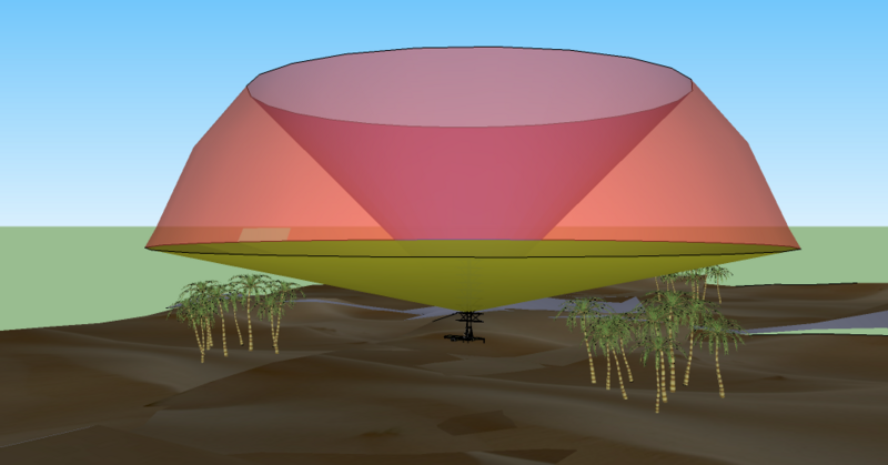
English: A simple 3D diagram (from Google Sketch) showing a representative radar coverage pattern. The rounded surface is the maximum range of the system (which may be "soft"), the lower limit is selected to avoid reflections from the ground, and the upper surface is the maximum angle, a factor of the antenna design. |
| Source | Own work |
| Author | Maury Markowitz |
Licensing
I, the copyright holder of this work, hereby publish it under the following licenses:
This file is licensed under the Creative Commons Attribution-Share Alike 3.0 Unported license.
- You are free:
- to share – to copy, distribute and transmit the work
- to remix – to adapt the work
- Under the following conditions:
- attribution – You must give appropriate credit, provide a link to the license, and indicate if changes were made. You may do so in any reasonable manner, but not in any way that suggests the licensor endorses you or your use.
- share alike – If you remix, transform, or build upon the material, you must distribute your contributions under the same or compatible license as the original.

|
Permission is granted to copy, distribute and/or modify this document under the terms of the GNU Free Documentation License, Version 1.2 or any later version published by the Free Software Foundation; with no Invariant Sections, no Front-Cover Texts, and no Back-Cover Texts. A copy of the license is included in the section entitled GNU Free Documentation License. |
You may select the license of your choice.
File history
Click on a date/time to view the file as it appeared at that time.
| Date/Time | Thumbnail | Dimensions | User | Comment | |
|---|---|---|---|---|---|
| current | 19:39, 10 August 2010 | | 958 × 502 (203 KB) | Maury Markowitz | {{Information |Description={{en|1=A simple 3D diagram (from Google Sketch) showing a representative radar coverage pattern. The rounded surface is the maximum range of the system (which may be "soft"), the lower limit is selected to avoid reflections from |
File usage
The following pages on the English Wikipedia use this file (pages on other projects are not listed):
Global file usage
The following other wikis use this file:
- Usage on es.wikipedia.org
- Usage on et.wikipedia.org
- Usage on fr.wikipedia.org
- Usage on pt.wikipedia.org
- Usage on ru.wikipedia.org
- Usage on zh.wikipedia.org