
File:Radar 45.PNG

Size of this preview: 760 × 599 pixels. Other resolutions: 305 × 240 pixels | 609 × 480 pixels | 974 × 768 pixels | 1,280 × 1,009 pixels | 1,352 × 1,066 pixels.
Original file (1,352 × 1,066 pixels, file size: 88 KB, MIME type: image/png)
| This is a file from the Wikimedia Commons. Information from its description page there is shown below. Commons is a freely licensed media file repository. You can help. |
Summary
| Description |
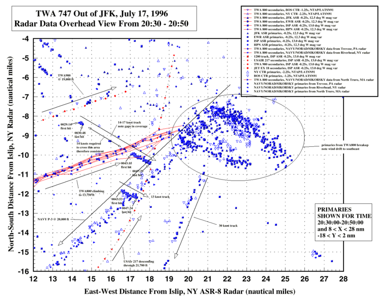
English: NTSB radar data plots around TWA 800 flightpath |
| Date |
|
| Source |
http://www.ntsb.gov/events/twa800/radar_45.gif
|
| Author | Lipsticked Pig at en.wikipedia |
Licensing
This image is a work of a National Transportation Safety Board employee, taken or made as part of an employee's official duties. As a work of the U.S. federal government, all NTSB images are in the public domain in the United States.
|
Original upload log
The original description page was here. All following user names refer to en.wikipedia.
Upload date | User | Bytes | Dimensions | Comment
- 2007-05-13 04:41 (UTC) | Lipsticked Pig | 112564 (bytes) | 1504×1076 | NTSB radar data plots around TWA 800 flightpath. Taken from http://www.ntsb.gov/events/twa800/radar_45.gif {{PD-USGov-NTSB}}
File history
Click on a date/time to view the file as it appeared at that time.
| Date/Time | Thumbnail | Dimensions | User | Comment | |
|---|---|---|---|---|---|
| current | 03:16, 9 March 2020 | | 1,352 × 1,066 (88 KB) | Ras67 | whitespace reduced |
| 10:48, 30 August 2011 |  | 1,504 × 1,076 (110 KB) | SreeBot |
File usage
The following pages on the English Wikipedia use this file (pages on other projects are not listed):
Global file usage
The following other wikis use this file: