
File:Race and ethnicity 2010- Paterson.png
No higher resolution available.
Race_and_ethnicity_2010-_Paterson.png (316 × 346 pixels, file size: 153 KB, MIME type: image/png)
| This is a file from the Wikimedia Commons. Information from its description page there is shown below. Commons is a freely licensed media file repository. You can help. |
Summary
| Description |
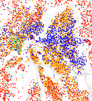
Maps of racial and ethnic divisions in US cities, inspired by Bill Rankin's map of Chicago, updated for Census 2010. Red is White, Blue is Black, Green is Asian, Orange is Hispanic, Yellow is Other, and each dot is 25 residents. Data from Census 2010. Base map © OpenStreetMap, CC-BY-SA |
| Date | |
| Source | Race and ethnicity 2010: New York City |
| Author | Eric Fischer |
| Other versions |
.png)
| Camera location | | View this and other nearby images on: OpenStreetMap |
|---|
Licensing
This file is licensed under the Creative Commons Attribution-Share Alike 2.0 Generic license.
- You are free:
- to share – to copy, distribute and transmit the work
- to remix – to adapt the work
- Under the following conditions:
- attribution – You must give appropriate credit, provide a link to the license, and indicate if changes were made. You may do so in any reasonable manner, but not in any way that suggests the licensor endorses you or your use.
- share alike – If you remix, transform, or build upon the material, you must distribute your contributions under the same or compatible license as the original.
File history
Click on a date/time to view the file as it appeared at that time.
| Date/Time | Thumbnail | Dimensions | User | Comment | |
|---|---|---|---|---|---|
| current | 15:51, 20 June 2017 | | 316 × 346 (153 KB) | Monopoly31121993 | File:Race and ethnicity 2010- New York City (5559914315).png cropped 89 % horizontally and 89 % vertically using CropTool with precise mode. |
.png)
File usage
The following pages on the English Wikipedia use this file (pages on other projects are not listed):
Global file usage
The following other wikis use this file:
- Usage on fi.wikipedia.org