
File:RCEP.png
Size of this preview: 600 × 599 pixels. Other resolutions: 240 × 240 pixels | 480 × 480 pixels | 769 × 768 pixels | 1,025 × 1,024 pixels | 2,050 × 2,048 pixels | 4,206 × 4,202 pixels.
Original file (4,206 × 4,202 pixels, file size: 616 KB, MIME type: image/png)
| This is a file from the Wikimedia Commons. Information from its description page there is shown below. Commons is a freely licensed media file repository. You can help. |

|
This map image could be re-created using vector graphics as an SVG file. This has several advantages; see Commons:Media for cleanup for more information. If an SVG form of this image is available, please upload it and afterwards replace this template with
{{vector version available|new image name}}.
It is recommended to name the SVG file “RCEP.svg”—then the template Vector version available (or Vva) does not need the new image name parameter. |
Summary
| Description |
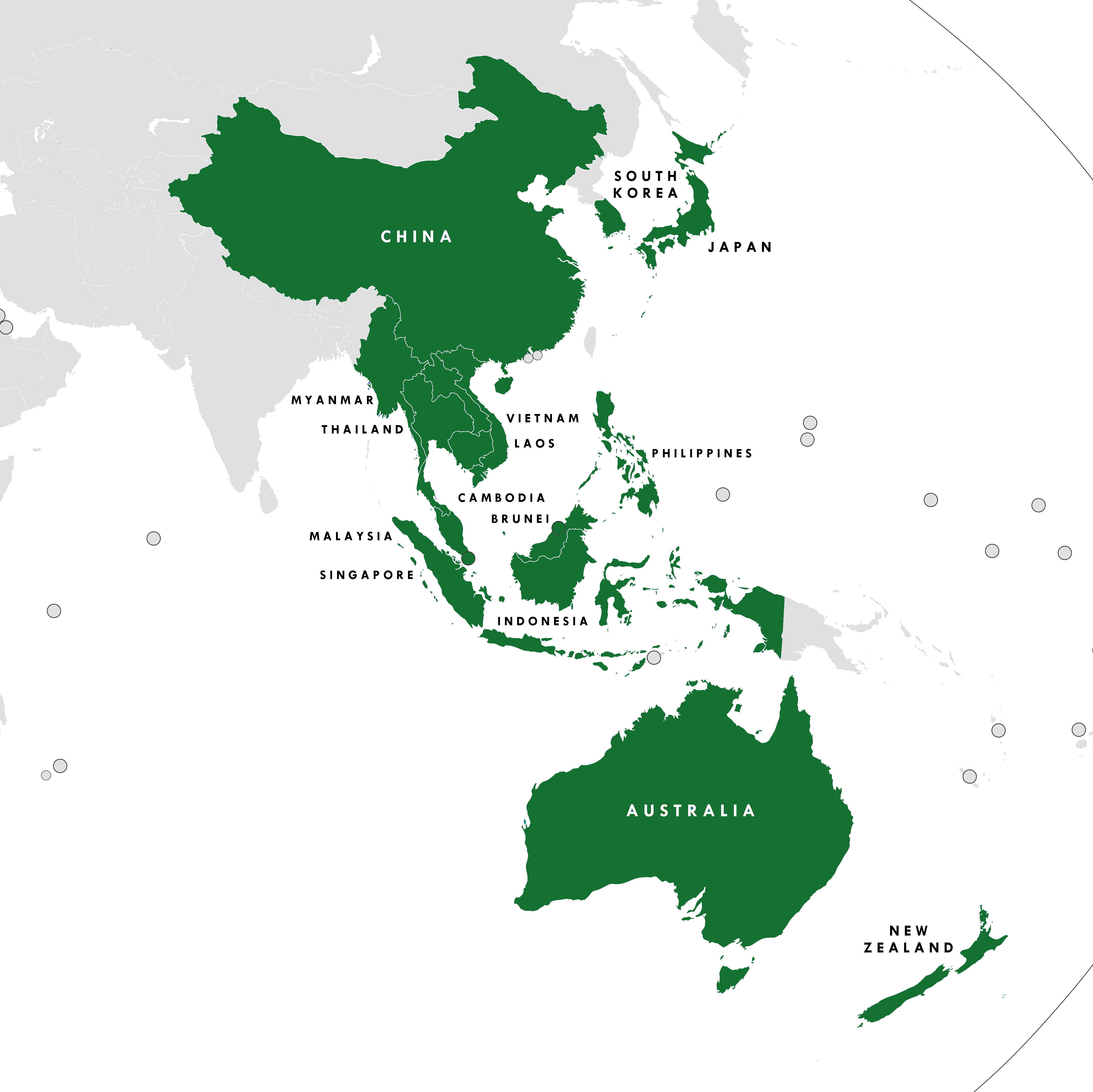
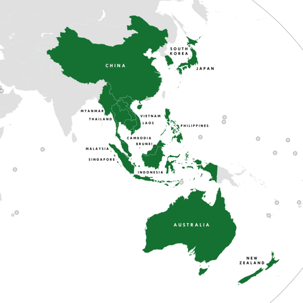
English: The members of the Regional Comprehensive Economic Partnership |
| Date | |
| Source | Own work |
| Author | Tiger 7253 |
| Other versions |
中文(简体):File:RCEP Chinese Map.png |
Licensing
I, the copyright holder of this work, hereby publish it under the following license:
This file is licensed under the Creative Commons Attribution-Share Alike 4.0 International license.
- You are free:
- to share – to copy, distribute and transmit the work
- to remix – to adapt the work
- Under the following conditions:
- attribution – You must give appropriate credit, provide a link to the license, and indicate if changes were made. You may do so in any reasonable manner, but not in any way that suggests the licensor endorses you or your use.
- share alike – If you remix, transform, or build upon the material, you must distribute your contributions under the same or compatible license as the original.
File history
Click on a date/time to view the file as it appeared at that time.
| Date/Time | Thumbnail | Dimensions | User | Comment | |
|---|---|---|---|---|---|
| current | 14:52, 16 July 2023 | | 4,206 × 4,202 (616 KB) | Mike Rohsopht | HK and MO are not members |
| 09:05, 2 April 2023 |  | 4,206 × 4,202 (631 KB) | Kwamikagami | rm. non-countries | |
| 06:43, 9 February 2022 |  | 4,206 × 4,202 (634 KB) | Lukas Abelshauser | Standardized color sheme for all RCEP members since it went in effect on 1 January 2022 | |
| 21:51, 2 January 2020 |  | 4,206 × 4,202 (648 KB) | Tiger7253 | Minor corrections - Australian and NZ external territories, HK and Macau in a lighter shade of purple to signify PRC suzerainty | |
| 06:10, 1 January 2020 |  | 4,206 × 4,202 (640 KB) | Afrogindahood | Changed the color of ASEAN Plus Six countries (Australia & New Zealand) from cobalt blue to teal for better contrast | |
| 09:24, 30 December 2019 |  | 4,206 × 4,202 (648 KB) | Tiger7253 | Reverted to version as of 17:34, 4 November 2019 (UTC) The previous colour scheme was standardised to be varying shades of blue/teal/purple. Please do not change it without a valid reason | |
| 00:24, 22 December 2019 |  | 4,206 × 4,202 (658 KB) | Afrogindahood | Changed the color of ASEAN Plus Three countries (China, Japan & South Korea) to bright purple and ASEAN Plus Six countries (Australia & New Zealand) to pink | |
| 00:09, 22 December 2019 |  | 4,206 × 4,202 (635 KB) | Afrogindahood | Addition of India | |
| 17:34, 4 November 2019 |  | 4,206 × 4,202 (648 KB) | Tiger7253 | Updating the image to reflect India's departure from RCEP. | |
| 16:57, 4 November 2019 |  | 4,206 × 4,202 (646 KB) | The Account 1 | Reverted to version as of 01:11, 3 April 2019 (UTC) These are the correct borders |
File usage
The following pages on the English Wikipedia use this file (pages on other projects are not listed):
Global file usage
The following other wikis use this file:
- Usage on ar.wikipedia.org
- Usage on cs.wikipedia.org
- Usage on da.wikipedia.org
- Usage on de.wikipedia.org
- Usage on es.wikipedia.org
- Usage on fa.wikipedia.org
- Usage on fi.wikipedia.org
- Usage on fr.wikipedia.org
- Usage on he.wikipedia.org
- Usage on hi.wikipedia.org
- Usage on id.wikipedia.org
- Usage on it.wikipedia.org
- Usage on kn.wikipedia.org
- Usage on ko.wikipedia.org
- Usage on lt.wikipedia.org
- Usage on ml.wikipedia.org
- Usage on ms.wikipedia.org
- Usage on my.wikipedia.org
- Usage on nl.wikipedia.org
- Usage on no.wikipedia.org
- Usage on pl.wikipedia.org
- Usage on pt.wikipedia.org
- Usage on ta.wikipedia.org
- Usage on th.wikipedia.org
- Usage on uk.wikipedia.org
- Usage on vi.wikipedia.org
- Usage on www.wikidata.org
- Usage on zh.wikipedia.org