
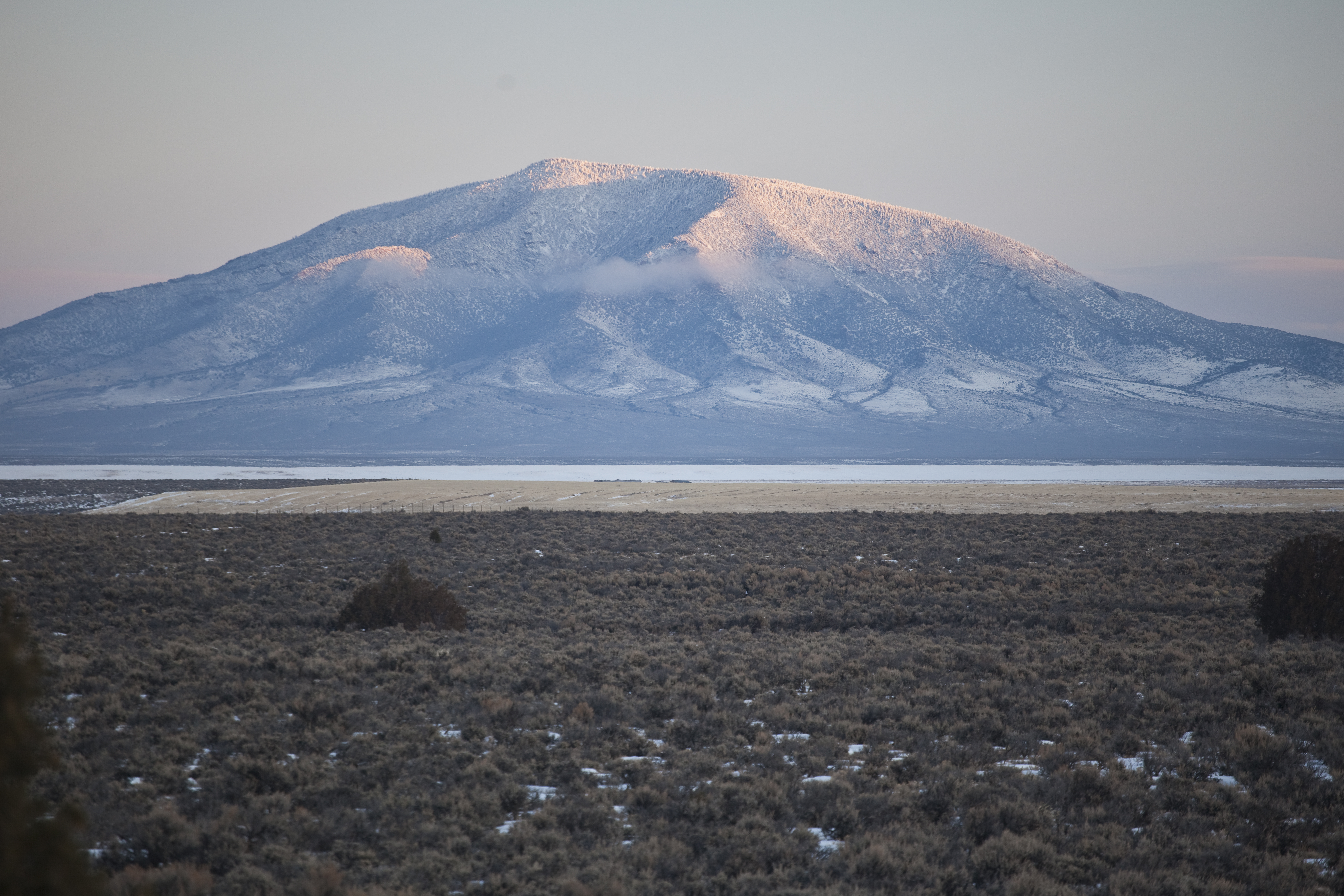
File:Río Grande del Norte NM (9421989961).jpg
Original file (5,436 × 3,625 pixels, file size: 9.58 MB, MIME type: image/jpeg)
| This is a file from the Wikimedia Commons. Information from its description page there is shown below. Commons is a freely licensed media file repository. You can help. |
.jpg)
Summary
| Description |
The Río Grande del Norte National Monument was established on March 25, 2013 by Presidential Proclamation. The monument includes approximately 242,500 acres of public land managed by the Bureau of Land Management. The landscape is comprised of rugged, wide open plains at an average elevation of 7,000 feet, dotted by volcanic cones, and cut by steep canyons with rivers tucked away in their depths. The Río Grande carves an 800 foot deep gorge through layers of volcanic basalt flows and ash. Among the volcanic cones in the Monument, Ute Mountain is the highest, reaching to 10,093 feet. The unique setting of the Monument also provides a wealth of recreational opportunities. Whitewater rafting, hunting, fishing, hiking, and mountain biking are some of the more outstanding activities that can be enjoyed in the Monument. The Wild Rivers Recreation Area at the confluence of the Río Grande and Red River includes campgrounds, scenic viewpoints, and hiking trails. La Junta Point, at Wild Rivers, provides a dramatic vista of the confluence of the two rivers, and is wheelchair accessible. The Orilla Verde Recreation Area includes campgrounds near the river’s edge, as well as boat launches. The Taos Valley overlook provides stunning views and trails for hiking and mountain biking. A major part of the Monument’s acreage lies west of the Río Grande. Here, seclusion is easy to find, with access only on rough dirt tracks or gravel roads. This is where you are most likely to see the vast herds of elk that bring hunters to the region. The Monument includes the Río Grande Wild and Scenic River and Red River Wild and Scenic River, designated by Congress in 1968 to provide present and future visitors the opportunity to experience the beauty of rivers in a natural free-flowing state. Learn more: www.blm.gov/nm/st/en/prog/blm_special_areas/national_monu... Photo: Bob Wick, BLM-California |
| Date | |
| Source | Río Grande del Norte NM |
| Author | Bureau of Land Management |
Licensing
- You are free:
- to share – to copy, distribute and transmit the work
- to remix – to adapt the work
- Under the following conditions:
- attribution – You must give appropriate credit, provide a link to the license, and indicate if changes were made. You may do so in any reasonable manner, but not in any way that suggests the licensor endorses you or your use.
| This image was originally posted to Flickr by mypubliclands at https://flickr.com/photos/91981596@N06/9421989961. It was reviewed on 5 August 2015 by FlickreviewR and was confirmed to be licensed under the terms of the cc-by-2.0. |
| This image is a work of a Bureau of Land Management* employee, taken or made as part of that person's official duties. As a work of the U.S. federal government, the image is in the public domain in the United States. *or predecessor organization |
File history
Click on a date/time to view the file as it appeared at that time.
| Date/Time | Thumbnail | Dimensions | User | Comment | |
|---|---|---|---|---|---|
| current | 20:19, 4 August 2015 | | 5,436 × 3,625 (9.58 MB) | Wilfredor | Transferred from Flickr via Flickr2Commons |
File usage
Global file usage
The following other wikis use this file:
- Usage on en.wikivoyage.org
- Usage on it.wikivoyage.org
- Usage on ru.wikipedia.org
- Usage on www.wikidata.org
.jpg)