
File:Putnam County Courthouse in Ottawa, southwestern angle.jpg

Size of this preview: 800 × 600 pixels. Other resolutions: 320 × 240 pixels | 640 × 480 pixels | 1,024 × 768 pixels | 1,280 × 960 pixels | 2,560 × 1,920 pixels | 2,816 × 2,112 pixels.
Original file (2,816 × 2,112 pixels, file size: 2.38 MB, MIME type: image/jpeg)
| This is a file from the Wikimedia Commons. Information from its description page there is shown below. Commons is a freely licensed media file repository. You can help. |
| This image appeared on Wikipedia's Main Page in the Did you know? column on 26 August 2010 (see archives). |
|
This is an image of a place or building that is listed on the National Register of Historic Places in the United States of America. Its reference number is 74001608. |
| Camera location | | View this and other nearby images on: OpenStreetMap |
|---|
| Description |
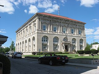
English: Southern and western sides of the Putnam County Courthouse, located at 245 E. Main Street (U.S. Route 224) in downtown Ottawa, Ohio, United States. Built in 1912, it is listed on the National Register of Historic Places. |
||
| Date | Taken on 24 June 2010 | ||
| Source | Own work | ||
| Author | Nyttend | ||
| Permission (Reusing this file) |
|
File history
Click on a date/time to view the file as it appeared at that time.
| Date/Time | Thumbnail | Dimensions | User | Comment | |
|---|---|---|---|---|---|
| current | 20:17, 25 June 2010 | | 2,816 × 2,112 (2.38 MB) | Nyttend | {{Location|41|1|11|N|84|2|47|W}} {{Information |Description={{en|Southern and western sides of the {{w|Putnam County Courthouse (Ohio)|Putnam County Courthouse}}, located at 245 E. Main Street ({{w|U.S. Route 224}}) in downtown {{w|Ottawa, Ohio|Ottawa}}, |
File usage
The following pages on the English Wikipedia use this file (pages on other projects are not listed):
Global file usage
The following other wikis use this file:
- Usage on ar.wikipedia.org
- Usage on ca.wikipedia.org
- Usage on ceb.wikipedia.org
- Usage on cy.wikipedia.org
- Usage on es.wikipedia.org
- Usage on eu.wikipedia.org
- Usage on ht.wikipedia.org
- Usage on hu.wikipedia.org
- Usage on ia.wikipedia.org
- Usage on it.wikipedia.org
- Usage on lld.wikipedia.org
- Usage on pl.wikipedia.org
- Usage on pt.wikipedia.org
- Usage on ru.wikipedia.org
- Usage on sr.wikipedia.org
- Usage on sv.wikipedia.org
- Usage on uk.wikipedia.org
- Usage on ur.wikipedia.org
- Usage on vi.wikipedia.org
- Usage on www.wikidata.org
- Usage on zh-min-nan.wikipedia.org