
File:Puscariu linguistic-map1.jpg

Size of this preview: 699 × 600 pixels. Other resolutions: 280 × 240 pixels | 560 × 480 pixels | 895 × 768 pixels | 1,194 × 1,024 pixels | 1,455 × 1,248 pixels.
Original file (1,455 × 1,248 pixels, file size: 682 KB, MIME type: image/jpeg)
| This is a file from the Wikimedia Commons. Information from its description page there is shown below. Commons is a freely licensed media file repository. You can help. |
Summary
| Description |
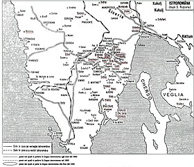
Istrorumeni in Istria. Nei due cerchi ovali sono indicate le due ultime localita' istrorumene rimaste nel 2000 in Istria: Valdarsa (istrorumeno Şuşńeviţa / croato Šušnjevica) e Seiane (istrorumeno Jeiăn / croato Žejane).English: Inside the two circles there are the two major istrorumenian villages in the year 2000 Istria: Valdarsa (Susnevita) and Seiane (Zejane). |
| Date | |
| Source | Farsarotul Society (enlarged original source map of 1928), Scanned from "L'Istrorumeno - La lingua, la cultura, la storia - Parliamo per salvarlo, Associazione di Amicizia Italo-Romena Decebal" (1992) by Marisa Ciceran who personally did the colorization for posting at: http://www.istrianet.org/istria/illustri/non-istrian/puscariu/works/studii-map.htm) |
| Author | PD-self |
Licensing
| I, the copyright holder of this work, release this work into the public domain. This applies worldwide. In some countries this may not be legally possible; if so: I grant anyone the right to use this work for any purpose, without any conditions, unless such conditions are required by law. |
File history
Click on a date/time to view the file as it appeared at that time.
| Date/Time | Thumbnail | Dimensions | User | Comment | |
|---|---|---|---|---|---|
| current | 03:55, 14 November 2006 | | 1,455 × 1,248 (682 KB) | Brunodambrosio | istroarumeni |
File usage
The following pages on the English Wikipedia use this file (pages on other projects are not listed):
Global file usage
The following other wikis use this file:
- Usage on ast.wikipedia.org
- Usage on ca.wikipedia.org
- Usage on cs.wikipedia.org
- Usage on eu.wikipedia.org
- Usage on ia.wikipedia.org
- Usage on ro.wikipedia.org
- Usage on ru.wikipedia.org
- Usage on sh.wikipedia.org
- Usage on www.wikidata.org