
File:Puncak Jaya glaciers 1850-2003 evolution map-fr.gif
No higher resolution available.
Puncak_Jaya_glaciers_1850-2003_evolution_map-fr.gif (511 × 590 pixels, file size: 2.45 MB, MIME type: image/gif, looped, 41 frames, 18 s)
| This is a file from the Wikimedia Commons. Information from its description page there is shown below. Commons is a freely licensed media file repository. You can help. |
This image has been assessed using the Quality image guidelines and is considered a Quality image.
|
Summary
| Description |
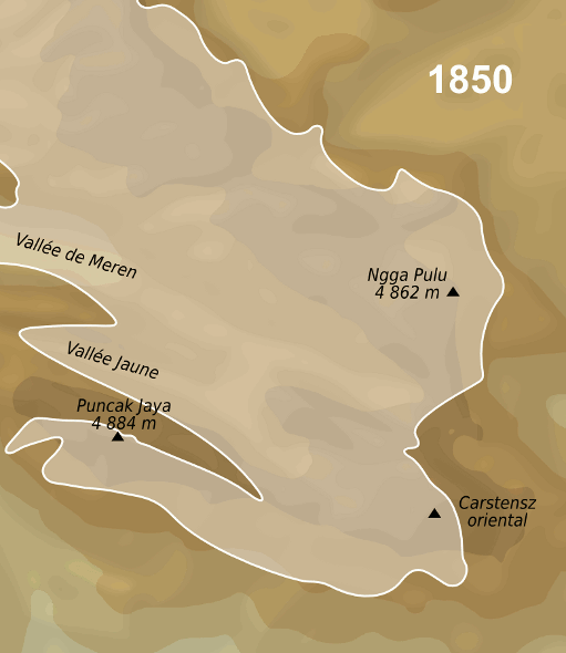
English: Evolution map of Puncak Jaya glaciers between the middle of 19th century and 2003.
Français : Carte de l'évolution des glaciers du Puncak Jaya, entre le milieu du 19è siècle et 2003. |
| Date | |
| Source |
travail personnel (own work). Sources :
|
| Author | Sémhur |
| Object location | | View this and other nearby images on: OpenStreetMap |
|---|
Licensing
I, the copyright holder of this work, hereby publish it under the following licenses:

|
Permission is granted to copy, distribute and/or modify this document under the terms of the GNU Free Documentation License, Version 1.2 or any later version published by the Free Software Foundation; with no Invariant Sections, no Front-Cover Texts, and no Back-Cover Texts. A copy of the license is included in the section entitled GNU Free Documentation License. |
This file is licensed under the Creative Commons Attribution-Share Alike 3.0 Unported, 2.5 Generic, 2.0 Generic and 1.0 Generic license.
- You are free:
- to share – to copy, distribute and transmit the work
- to remix – to adapt the work
- Under the following conditions:
- attribution – You must give appropriate credit, provide a link to the license, and indicate if changes were made. You may do so in any reasonable manner, but not in any way that suggests the licensor endorses you or your use.
- share alike – If you remix, transform, or build upon the material, you must distribute your contributions under the same or compatible license as the original.
You may select the license of your choice.
File history
Click on a date/time to view the file as it appeared at that time.
| Date/Time | Thumbnail | Dimensions | User | Comment | |
|---|---|---|---|---|---|
| current | 15:12, 15 January 2012 | | 511 × 590 (2.45 MB) | Sémhur | 3 - Again... |
| 16:01, 28 April 2010 |  | 520 × 600 (1.96 MB) | Sémhur | 2 - Temporary ugly smaller size because of the animated gifs violating 12.5MP rule. | |
| 18:25, 8 April 2009 |  | 779 × 899 (3.49 MB) | Sémhur | {{Information |Description={{en|1=Evolution map of Puncak Jaya glaciers between the middle of 19th century and 2003.}} {{fr|1=Carte de l'évolution des glaciers du Puncak Jaya, entre le milieu du 19è siècle et 200 |
File usage
The following pages on the English Wikipedia use this file (pages on other projects are not listed):
Global file usage
The following other wikis use this file:
- Usage on ast.wikipedia.org
- Usage on bg.wikipedia.org
- Usage on cs.wikipedia.org
- Usage on de.wikipedia.org
- Usage on de.wikivoyage.org
- Usage on el.wikipedia.org
- Usage on es.wikipedia.org
- Usage on fr.wikipedia.org
- Usage on hi.wikipedia.org
- Usage on id.wikipedia.org
- Usage on nl.wikipedia.org
- Usage on pt.wikipedia.org
- Usage on sv.wikipedia.org
- Usage on uk.wikipedia.org
- Usage on zh.wikipedia.org