
File:Prussian-Polish border in the 18th century.png

Size of this preview: 800 × 571 pixels. Other resolutions: 320 × 228 pixels | 640 × 457 pixels | 1,024 × 731 pixels | 1,280 × 914 pixels | 1,755 × 1,253 pixels.
Original file (1,755 × 1,253 pixels, file size: 6.29 MB, MIME type: image/png)
| This is a file from the Wikimedia Commons. Information from its description page there is shown below. Commons is a freely licensed media file repository. You can help. |
Summary
| Author |
|
| Description |
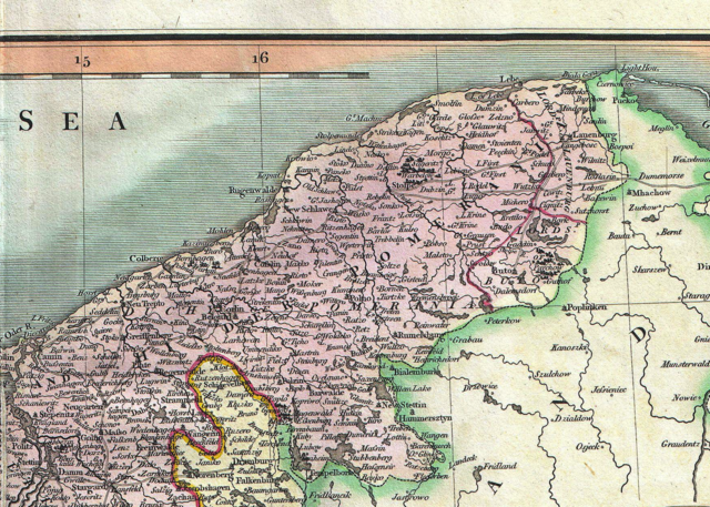
English: An attractive example of John Cary’s 1801 map of Upper Saxony, Germany. Covers from the Baltic Sea south to Franconia, Bavaria, Bohemia and Moravia. Extends eastward as far as Poland. Includes the Duchy of Silesia, the Duchy of Lusatia, Prussian Pomerania, Electoral Mark of Brandenburg, and the Margraviate of Meissen. Notes the cities of Berlin, Prague, Dresden, and Leipzig among many others. Highly detailed with color coding according to region. Shows forests, cities, palaces, forts, roads and rivers. All in all, one of the most interesting and attractive atlas maps of Upper Saxony to appear in first years of the 19th century. Prepared in 1801 by John Cary for issue in his magnificent 1808 New Universal Atlas . |
| Date | 9 August 2012, 09:29 (UTC) |
| Dimensions | height: 18.5 in (46.9 cm); width: 20.5 in (52 cm) |
| Accession number |
Geographicus link: UpperSaxony-cary-1799 |
| Source/Photographer |
This file was derived from: 1801 Cary Map of Upper Saxony, Germany ( Berlin, Dresden ) - Geographicus - UpperSaxony-cary-1799.jpg: |
_-_Geographicus_-_UpperSaxony-cary-1799.jpg)
| This is a retouched picture, which means that it has been digitally altered from its original version. Modifications: Taking part of the map. The original can be viewed here: 1801 Cary Map of Upper Saxony, Germany ( Berlin, Dresden ) - Geographicus - UpperSaxony-cary-1799.jpg:
|
Licensing
|
This is a faithful photographic reproduction of a two-dimensional, public domain work of art. The work of art itself is in the public domain for the following reason:
The official position taken by the Wikimedia Foundation is that "faithful reproductions of two-dimensional public domain works of art are public domain".
This photographic reproduction is therefore also considered to be in the public domain in the United States. In other jurisdictions, re-use of this content may be restricted; see Reuse of PD-Art photographs for details. | ||||
Original upload log
This image is a derivative work of the following images:
- File:1801_Cary_Map_of_Upper_Saxony,_Germany_(_Berlin,_Dresden_)_-_Geographicus_-_UpperSaxony-cary-1799.jpg licensed with PD-Art, PD-old-100
- 2011-03-22T12:35:00Z BotMultichillT 5000x4474 (8734693 Bytes) {{subst:User:Multichill/Geographicus |link=http://www.geographicus.com/P/AntiqueMap/UpperSaxony-cary-1799 |product_name=1801 Cary Map of Upper Saxony, Germany ( Berlin, Dresden ) |map_title=A New Map of the Circle of Upper Sa
Uploaded with derivativeFX
File history
Click on a date/time to view the file as it appeared at that time.
| Date/Time | Thumbnail | Dimensions | User | Comment | |
|---|---|---|---|---|---|
| current | 09:39, 9 August 2012 | | 1,755 × 1,253 (6.29 MB) | Opole.pl | == {{int:filedesc}} == {{Information |Description={{en|An attractive example of John Cary’s 1801 map of Upper Saxony, Germany. Covers from the Baltic Sea south to Franconia, Bavaria, Bohemia and Moravia. Extends eastward as far as Poland. Includes... |
File usage
The following pages on the English Wikipedia use this file (pages on other projects are not listed):
Global file usage
The following other wikis use this file:
- Usage on fr.wikipedia.org
- Usage on vi.wikipedia.org
- Usage on zh.wikipedia.org