
File:ProjectK.png

Size of this preview: 800 × 415 pixels. Other resolutions: 320 × 166 pixels | 640 × 332 pixels | 1,213 × 630 pixels.
Original file (1,213 × 630 pixels, file size: 1.44 MB, MIME type: image/png)
| This is a file from the Wikimedia Commons. Information from its description page there is shown below. Commons is a freely licensed media file repository. You can help. |
Summary
| Description |
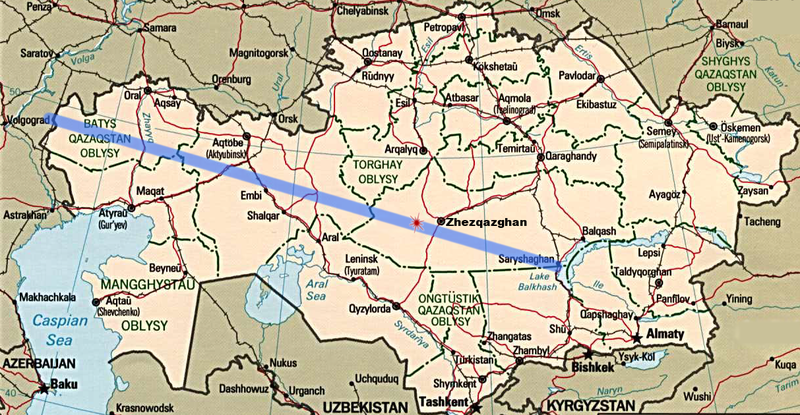
English: Map of Kazakhstan originally produced by U.S. Central Intelligence Agency. I have modified the map to illustrate the Wikipedia article on the Project K high-altitude nuclear tests by the Soviet Union. |
| Date | Unknown date |
| Source | http://www.lib.utexas.edu/maps |
| Author | U.S. Central Intelligence Agency, with modifications by me. |
Licensing
This image is in the public domain because it contains materials that originally came from the United States Central Intelligence Agency's World Factbook.
|
 |
File history
Click on a date/time to view the file as it appeared at that time.
| Date/Time | Thumbnail | Dimensions | User | Comment | |
|---|---|---|---|---|---|
| current | 11:29, 28 January 2010 | | 1,213 × 630 (1.44 MB) | X5dna | {{Information |Description={{en|1=Map of Kazakhstan originally produced by U.S. Central Intelligence Agency. I have modified the map to illustrate the Wikipedia article on the Project K high-altitude nuclear tests by the Soviet Union.}} |Source=http://www |
File usage
The following pages on the English Wikipedia use this file (pages on other projects are not listed):
Global file usage
The following other wikis use this file:
- Usage on ca.wikipedia.org
- Usage on es.wikipedia.org
- Usage on it.wikipedia.org
- Usage on ru.wikipedia.org
- Usage on uk.wikipedia.org
- Usage on www.wikidata.org