
File:Powell-Chart-1822.png

Size of this preview: 800 × 533 pixels. Other resolutions: 320 × 213 pixels | 640 × 426 pixels | 1,024 × 682 pixels | 1,280 × 852 pixels | 2,357 × 1,569 pixels.
Original file (2,357 × 1,569 pixels, file size: 10.6 MB, MIME type: image/png)
| This is a file from the Wikimedia Commons. Information from its description page there is shown below. Commons is a freely licensed media file repository. You can help. |
Summary
| Description |
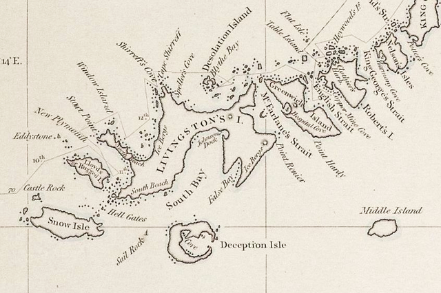
English: 1822 chart of the South Shetland Islands and South Orkney Islands, Antarctica by George Powell (fragment) |
| Date | |
| Source | https://www.researchgate.net/publication/318421288_Antarctic_Nature_History_Utilization_Geographic_Names_and_Bulgarian_Participation_in_Bulgarian |
| Author | George Powell: Chart of South Shetland including Coronation Island, &c. from the exploration of the sloop Dove in the years 1821 and 1822 by George Powell Commander of the same. Scale ca. 1:200000. London: Laurie, 1822 |
Licensing
|
This work is in the public domain in its country of origin and other countries and areas where the copyright term is the author's life plus 70 years or fewer. This work is in the public domain in the United States because it was published (or registered with the U.S. Copyright Office) before January 1, 1929. | |
| This file has been identified as being free of known restrictions under copyright law, including all related and neighboring rights. | |
| Annotations | This image is annotated: View the annotations at Commons |
File history
Click on a date/time to view the file as it appeared at that time.
| Date/Time | Thumbnail | Dimensions | User | Comment | |
|---|---|---|---|---|---|
| current | 07:19, 18 February 2019 | | 2,357 × 1,569 (10.6 MB) | Apcbg | quality |
| 10:55, 17 February 2019 |  | 1,369 × 863 (3.39 MB) | Apcbg | User created page with UploadWizard |
File usage
The following pages on the English Wikipedia use this file (pages on other projects are not listed):
- Cape Shirreff
- Devils Point
- Eddystone Rocks (South Shetland Islands)
- Etar Snowfield
- False Bay (Livingston Island)
- George Powell (sealer)
- Greenwich Island
- Guangzhou Peninsula
- Ivanov Beach
- Johnsons Dock
- Livingston Island
- McFarlane Strait
- Morton Strait
- New Plymouth (Livingston Island)
- Phantom island
- Renier Point
- Robbery Beaches
- Rugged Island (South Shetland Islands)
- Sail Rock (South Shetland Islands)
- Shirreff Cove
- Snow Island (South Shetland Islands)
- South Bay (Livingston Island)
- South Beaches (Livingston Island)
- South Shetland Islands
- Spiller Cove
- Start Point (Livingston Island)
- Tangra Mountains
- Window Island
- Yankee Harbour
- Portal:Islands/Selected article
- Portal:Islands/Selected article/7
Global file usage
The following other wikis use this file:
- Usage on ar.wikipedia.org
- Usage on bn.wikipedia.org
- Usage on eu.wikipedia.org
- Usage on he.wikipedia.org
- Usage on it.wikipedia.org
- Usage on mk.wikipedia.org
- Usage on pt.wikipedia.org
- Usage on sl.wikipedia.org
- Usage on uk.wikipedia.org
- Usage on uz.wikipedia.org
- Usage on www.wikidata.org