
File:Potomac River passing through two water gaps.jpg
No higher resolution available.
Potomac_River_passing_through_two_water_gaps.jpg (720 × 480 pixels, file size: 147 KB, MIME type: image/jpeg)
| This is a file from the Wikimedia Commons. Information from its description page there is shown below. Commons is a freely licensed media file repository. You can help. |
Summary
| Description |
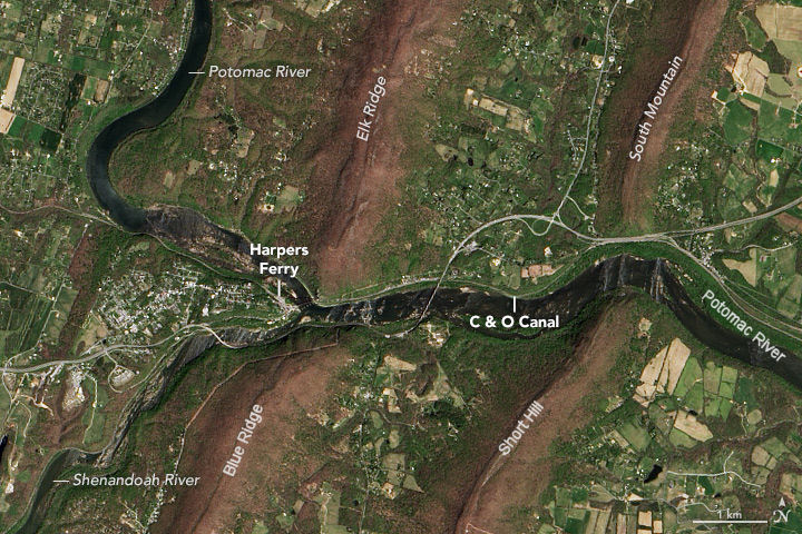
English: The passage of the Potomac River through two water gaps just downstream of Harpers Ferry |
| Date | |
| Source | https://earthobservatory.nasa.gov/IOTD/view.php?id=89457 |
| Author | NASA Earth Observatory images by Jesse Allen, using Landsat data from the U.S. Geological Survey. (Landsat 8) |
Description of this image on the NASA Earth Observatory page: "Satellites offer an even loftier view. On April 20, 2016, the Operational Land Imager (OLI) on Landsat 8 captured this view of the water gap from an altitude of about 700 kilometers (430 miles). While spring warming has cast the valleys in green, the cooler tops of the ridges remained brown."
Note: I (P999) modified this image by adding three labels to it,
Licensing
| This file is in the public domain in the United States because it was solely created by NASA. NASA copyright policy states that "NASA material is not protected by copyright unless noted". (See Template:PD-USGov, NASA copyright policy page or JPL Image Use Policy.) | ||
 |
Warnings:
|
File history
Click on a date/time to view the file as it appeared at that time.
| Date/Time | Thumbnail | Dimensions | User | Comment | |
|---|---|---|---|---|---|
| current | 23:01, 22 February 2018 | | 720 × 480 (147 KB) | P999 | User created page with UploadWizard |
File usage
The following pages on the English Wikipedia use this file (pages on other projects are not listed):
Global file usage
The following other wikis use this file:
- Usage on ar.wikipedia.org