
File:Position of Northland.png
No higher resolution available.
Position_of_Northland.png (405 × 590 pixels, file size: 7 KB, MIME type: image/png)
| This is a file from the Wikimedia Commons. Information from its description page there is shown below. Commons is a freely licensed media file repository. You can help. |

|
This locator map image could be re-created using vector graphics as an SVG file. This has several advantages; see Commons:Media for cleanup for more information. If an SVG form of this image is available, please upload it and afterwards replace this template with
{{vector version available|new image name}}.
It is recommended to name the SVG file “Position of Northland.svg”—then the template Vector version available (or Vva) does not need the new image name parameter. |
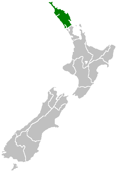
English: Region of New Zealand, position on the map (source:English Wiki)
| |
This work has been released into the public domain by its author, Furius, at the English Wikipedia project. This applies worldwide. In case this is not legally possible: |
File history
Click on a date/time to view the file as it appeared at that time.
| Date/Time | Thumbnail | Dimensions | User | Comment | |
|---|---|---|---|---|---|
| current | 07:40, 27 April 2005 | | 405 × 590 (7 KB) | Domie~commonswiki | Region of New Zealand, position on the map (source:English Wiki) {{PD}} Category:Maps of New Zealand |
File usage
More than 100 pages use this file. The following list shows the first 100 pages that use this file only. A full list is available.
- Aorangaia Island
- Araara Island
- Arakaninihi Island
- Aroha Island
- Bay of Islands County
- Brynderwyn
- Brynderwyn Range
- Bulrush Lake (Northland)
- Cape Brett Peninsula
- Cape Maria van Diemen
- Cavalli Islands
- Dargaville Aerodrome
- Half Mile Lagoon
- Henderson Bay
- Horahora, Whangārei
- Horeke basalts
- Jellicoe Channel
- Kaikohe Hill
- Kokopu, New Zealand
- Lake Half
- Lake Humuhumu
- Lake Kahuparere
- Lake Kaiwai
- Lake Kanono
- Lake Kapoai
- Lake Karaka
- Lake Karoro / Mathews
- Lake Kihona
- Lake Manuwai
- Lake Mokeno
- Lake Morehurehu
- Lake Ngakapua
- Lake Ngakeketa
- Lake Ngatu
- Lake Ora
- Lake Otapuiti
- Lake Parawanui
- Lake Puhau
- Lake Rotokawau (Aupōuri Peninsula)
- Lake Rotokereru
- Lake Rotomata
- Lake Rotootuauru
- Lake Rotopouua
- Lake Rotoroa (Northland)
- Lake Rototuna
- Lake Rototuna Lower
- Lake Taeore
- Lake Tairutu
- Lake Tauanui
- Lake Te Kahika
- Lake Wahakari
- Lake Waikanae
- Lake Waikaramu
- Lake Waimimiha
- Lake Waingaro
- Lake Waingata
- Lake Wainui
- Lake Waiparera
- Lake Waiporohita
- Lake Wairere
- Lake Whakaneke
- Lake Whirirau
- Lake Ōwhareiti
- Mangonui County
- Maungataniwha Range
- Maungaturoto (volcano)
- Motukawanui Island
- Mount Hikurangi (Northland)
- Mount Manaia
- Ngawha geothermal field
- Omanaia
- Oromahoe
- Pakotai
- Phoebes Lake
- Poroti
- Pouerua
- Purua
- Rainbow Falls (Waianiwaniwa)
- Rotopouri
- Salt Lake (New Zealand)
- Shag Lake
- Split Lake (New Zealand)
- Swan Lake (New Zealand)
- Tarahi (volcano)
- Tauanui
- Tauraroa
- Taurikura
- Te Ahuahu
- Te Puke (volcano)
- The Big Lake (New Zealand)
- Titoki, New Zealand
- Towai
- Umawera
- Urupukapuka Island
- Waihopo Lake
- Waimamaku
- Waitahora Lagoon
- Weber County, New Zealand
- Whangarei County
- Whangaroa County
View more links to this file.
Global file usage
The following other wikis use this file:
- Usage on af.wikipedia.org
- Usage on ceb.wikipedia.org
- Usage on de.wikivoyage.org
- Usage on eu.wikipedia.org
- Usage on fa.wikipedia.org
- Usage on fi.wikipedia.org
- Usage on gd.wikipedia.org
- Usage on hi.wikipedia.org
- Usage on hr.wikipedia.org
- Usage on id.wikipedia.org
- Usage on ja.wikipedia.org
- Usage on ko.wikipedia.org
- Usage on mi.wikipedia.org
- Whangārei-terenga-paraoa
- Portland, Aotearoa
- Wheki Valley
- Template:Maramara matawhenua (Tai-tokerau)
- Whangārei Heads
- Waiotama
- Avoca
- Maropiu
- Taurikura
- Reotahi Bay
- Tangiteroria
- Ocean Beach
- Marsden Bay
- Takahiwai
- Oakleigh
- Waihue
- Mamaranui
- Urquharts Bay
- Maungakaramea
- Tangihua
- Kirikopuni
- Mangapai
- Maitahi
- Tangowahine
- Omamari
- Moewhare
- Tauraroa
- Pukehuia
- Marsden Point
- Springfield
- Hoanga
- Omana
- Te Wharau
- Parahaka
- Pikiwahine
- Awakino Point
- Parore
View more global usage of this file.