
File:Portland map.png
Original file (945 × 843 pixels, file size: 572 KB, MIME type: image/png)
| This is a file from the Wikimedia Commons. Information from its description page there is shown below. Commons is a freely licensed media file repository. You can help. |

|
This map image could be re-created using vector graphics as an SVG file. This has several advantages; see Commons:Media for cleanup for more information. If an SVG form of this image is available, please upload it and afterwards replace this template with
{{vector version available|new image name}}.
It is recommended to name the SVG file “Portland map.svg”—then the template Vector version available (or Vva) does not need the new image name parameter. |
| Description |
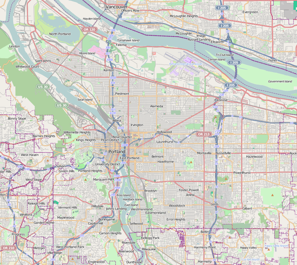
Map of Portland, Oregon This map of Portland was created from OpenStreetMap project data, collected by the community. This map may be incomplete, and may contain errors. Don't rely solely on it for navigation. |
|||||||||
| Date | ||||||||||
| Source | You may find a page on the OpenStreetMap wiki page for Portland | |||||||||
| Creator |
OpenStreetMap contributors OpenStreetMap contributors |
|||||||||
| Permission (Reusing this file) |
OpenStreetMap data is available under the Open Database License (details). Map tiles are licensed under the Creative Commons Attribution-ShareAlike 2.0 license (CC-BY-SA 2.0).
This file is licensed under the Creative Commons Attribution-Share Alike 2.0 Generic license.
|
|||||||||
| Geotemporal data | ||||||||||
| Bounding box |
|
|||||||||
| Georeferencing | If inappropriate please set warp_status = skip to hide. | |||||||||
File history
Click on a date/time to view the file as it appeared at that time.
| Date/Time | Thumbnail | Dimensions | User | Comment | |
|---|---|---|---|---|---|
| current | 21:38, 19 December 2012 | | 945 × 843 (572 KB) | Calliopejen1 | {{OpenStreetMap | name = Portland | location = Portland | description = Map of Portland, Oregon | top = 45.6358 | bottom = 45.4333 | left = -122.8041 | right = -122.4773 | date = {{dat... |
File usage
More than 100 pages use this file. The following list shows the first 100 pages that use this file only. A full list is available.
- Alberta Arts District
- Alexander B. and Anna Balch Hamilton House
- Annand–Loomis House
- Arnold–Park Log Home
- Aubrey R. Watzek House
- Avalon Theatre (Portland, Oregon)
- Ayer–Shea House
- Bagdad Theatre
- Ball–Ehrman House
- Bates–Seller House
- Blaine Smith House
- Bohnsen Cottages
- Burke–Clark House
- Cardwell–Holman House
- Cardwell–Parrish House
- Caroline W. and M. Louise Flanders House
- Chiles Center
- Christine Becker House
- Clarke–Mossman House
- Cohn–Sichel House
- Coleman–Scott House
- Congregation Beth Israel (Portland, Oregon)
- Costanzo Family House
- Crystal Springs Rhododendron Garden
- Digman–Zidell House
- Doernbecher Children's Hospital
- Douglas Building
- Dr. Frank B. Kistner House
- Durham–Jacobs House
- Edward D. Dupont House
- Elizabeth B. Gowanlock House
- Elizabeth Ducey House
- Ernest Haycox Estate
- Frank E. Dooly House
- Frederick and Grace Greenwood House
- Genoa Building
- Giesy–Failing House
- Hall–Chaney House
- Harry T. Nicolai House
- Henry C. and Wilhemina Bruening House
- Henry E. Dosch House
- Henry Hahn House
- Henry M. Grant House
- Henry Sensel Building
- Herman Vetter House
- Hollywood Theatre (Portland, Oregon)
- Holt–Saylor–Liberto House
- Hoyt Arboretum
- International Rose Test Garden
- Interstate Bridge
- Isaac Neuberger House
- James Hickey House
- James S. Polhemus House
- Jessie M. Raymond House
- Jewish Shelter Home
- Johan Poulsen House
- John M. Wallace Fourplex
- John Palmer House (Portland, Oregon)
- John Ross Tower
- Kennedy School
- Kenton Hotel
- Lan Su Chinese Garden
- Leach Botanical Garden
- Legacy Emanuel Medical Center
- Legacy Good Samaritan Medical Center
- Markle–Pittock House
- Marquam Manor
- Milton W. Smith House
- Mirabella Portland
- Moda Center
- Moses and Ida Kline House
- Mount Hood Masonic Temple
- Mount Tabor (Oregon)
- OHSU Center for Health & Healing
- Oregon Health & Science University Hospital
- Oregon Museum of Science and Industry
- Otho Poole House
- Palestine Lodge
- Parkrose Heights, Portland, Oregon
- Paul F. Murphy House
- Peacock Lane
- Philip Buehner House
- Pittock Mansion
- Portland Japanese Garden
- Providence Park
- Providence Portland Medical Center
- Satyricon (nightclub)
- Shriners Hospital for Children (Portland)
- Shriners Hospital for Crippled Children (Portland, Oregon)
- St. Johns Post Office (Portland, Oregon)
- Tannler–Armstrong House
- The Ardea
- The Grotto (Portland, Oregon)
- Thomas Graham Building
- Washington Park (Portland, Oregon)
- Wilhelmina Mohle House
- William F. Mangels Four-Row Carousel
- Wilson–South House
- Woodland Park Hospital
- World Forestry Center
View more links to this file.
Global file usage
The following other wikis use this file:
- Usage on ar.wikipedia.org
- Usage on ceb.wikipedia.org
- Usage on fa.wikipedia.org
- Usage on fr.wikipedia.org
- Usage on ja.wikipedia.org
- Usage on kn.wikipedia.org
- Usage on lv.wikipedia.org
- Usage on pl.wikipedia.org
- Usage on pl.wikibooks.org
- Usage on simple.wikipedia.org
- Usage on si.wikipedia.org
- Usage on sv.wikipedia.org
- Usage on tr.wikipedia.org
- Usage on ur.wikipedia.org
- Usage on war.wikipedia.org
- Usage on zh.wikipedia.org