
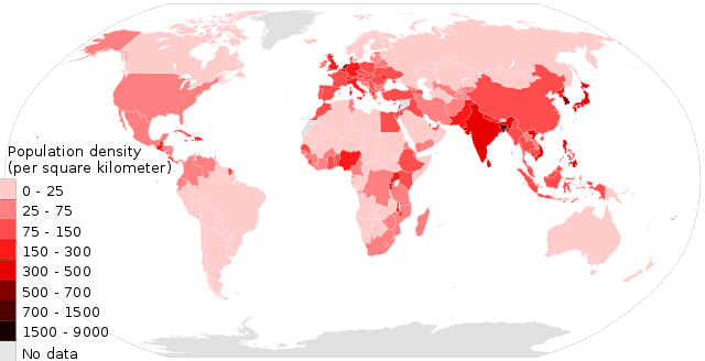
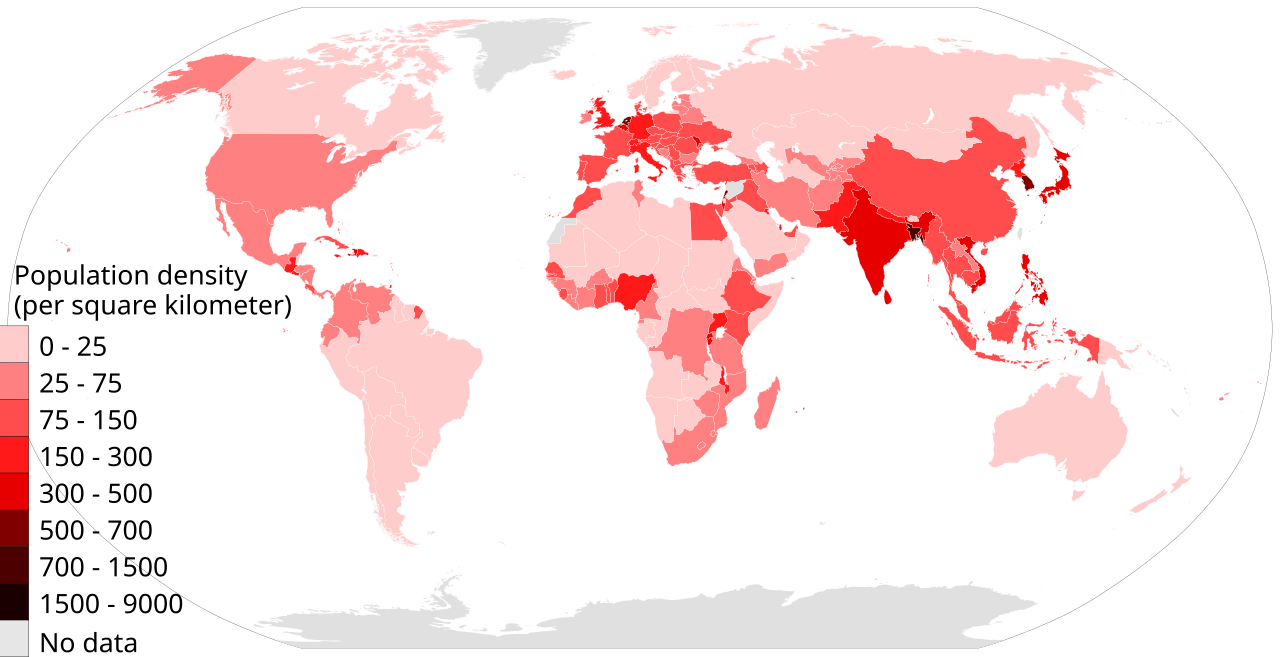
File:Population density countries 2017 world map, people per sq km.svg

Size of this PNG preview of this SVG file: 800 × 410 pixels. Other resolutions: 320 × 164 pixels | 640 × 328 pixels | 1,024 × 525 pixels | 1,280 × 656 pixels | 2,560 × 1,313 pixels | 864 × 443 pixels.
Original file (SVG file, nominally 864 × 443 pixels, file size: 1.55 MB)
| This is a file from the Wikimedia Commons. Information from its description page there is shown below. Commons is a freely licensed media file repository. You can help. |
Summary
| Description |
English: Population per square Kilometer.
Source: Data table compiled byUnited Nations ESA (2017) This is a derivative work on BlankMap-World6.svg available on Wikimedia commons. This SVG file has been tested with W3C, and it passed "This document was successfully checked as SVG 1.1 + XHTML + MathML 3.0!". |
| Date | |
| Source | Own work |
| Author | User: MS Sarah Welham's Sarah Welch |
| Permission (Reusing this file) |
2017 |
| Other versions |
Licensing
I, the copyright holder of this work, hereby publish it under the following license:
This file is licensed under the Creative Commons Attribution-Share Alike 4.0 International license.
- You are free:
- to share – to copy, distribute and transmit the work
- to remix – to adapt the work
- Under the following conditions:
- attribution – You must give appropriate credit, provide a link to the license, and indicate if changes were made. You may do so in any reasonable manner, but not in any way that suggests the licensor endorses you or your use.
- share alike – If you remix, transform, or build upon the material, you must distribute your contributions under the same or compatible license as the original.
File history
Click on a date/time to view the file as it appeared at that time.
| Date/Time | Thumbnail | Dimensions | User | Comment | |
|---|---|---|---|---|---|
| current | 21:53, 21 May 2017 | | 864 × 443 (1.55 MB) | Ms Sarah Welch | User created page with UploadWizard |
File usage
The following pages on the English Wikipedia use this file (pages on other projects are not listed):
Global file usage
The following other wikis use this file:
- Usage on ar.wikipedia.org
- Usage on ast.wikipedia.org
- Usage on bg.wikipedia.org
- Usage on eo.wikipedia.org
- Usage on he.wikipedia.org
- Usage on pl.wikipedia.org
- Usage on th.wikipedia.org