
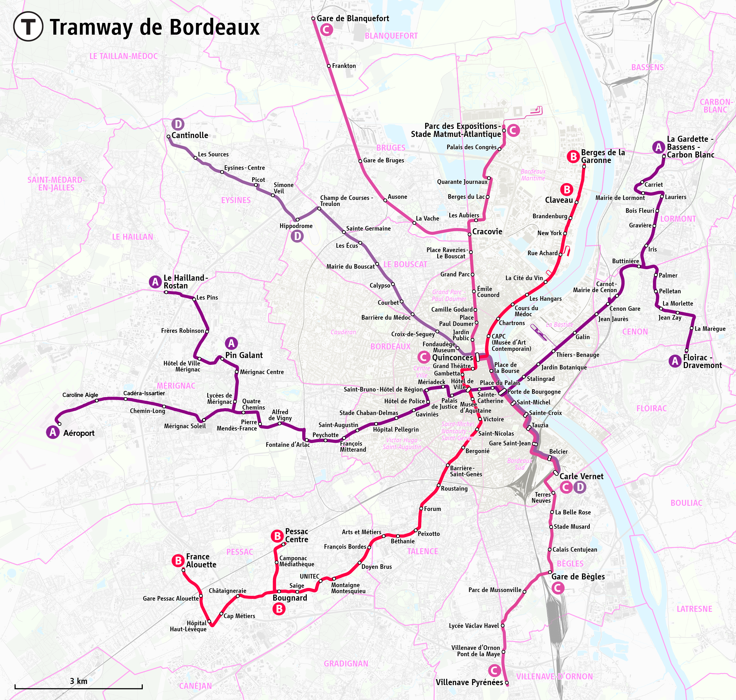
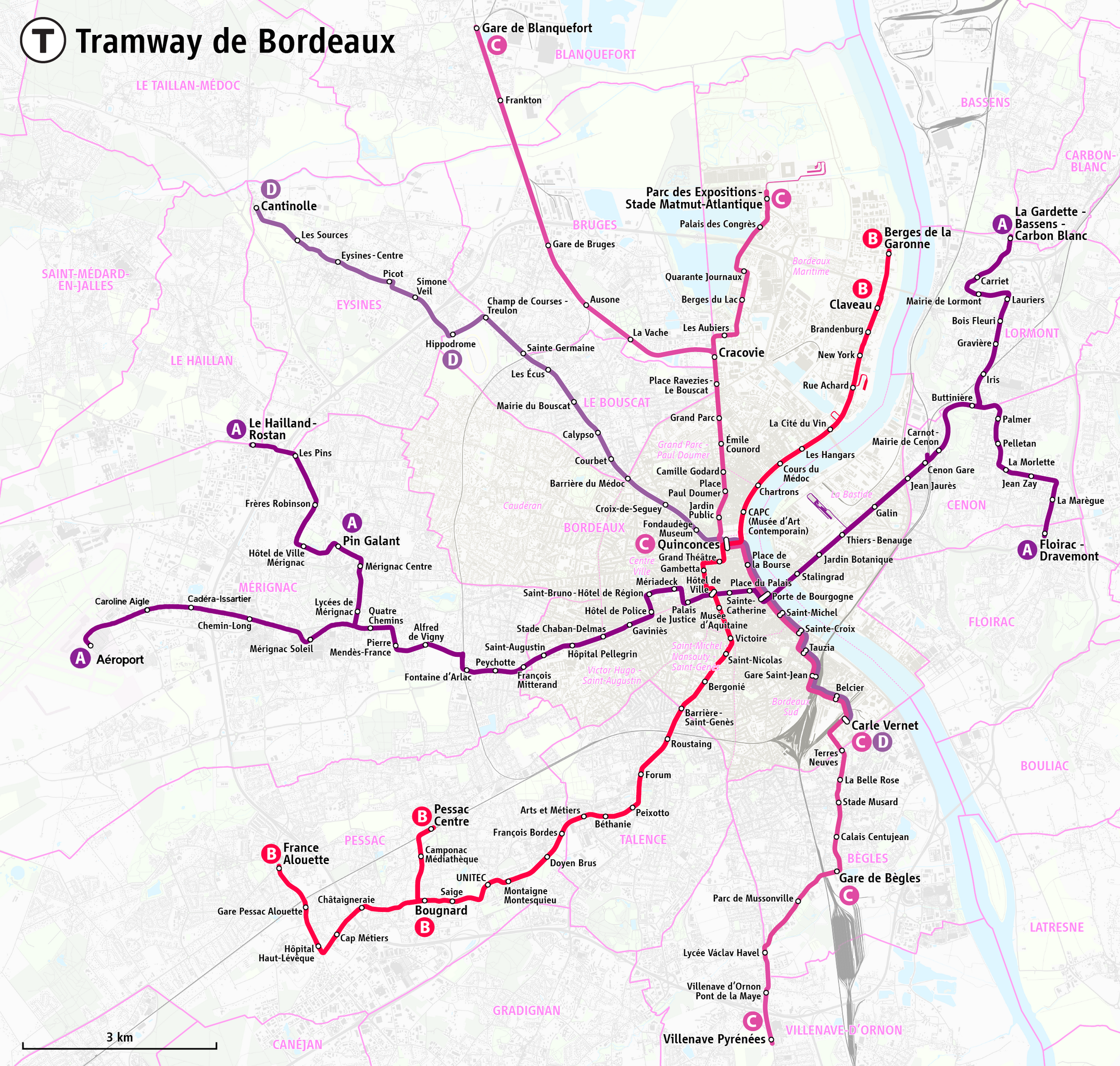
File:Plan du réseau des tramways de Bordeaux.png
Size of this preview: 630 × 600 pixels. Other resolutions: 252 × 240 pixels | 504 × 480 pixels | 807 × 768 pixels | 1,076 × 1,024 pixels | 2,151 × 2,048 pixels | 2,567 × 2,444 pixels.
Original file (2,567 × 2,444 pixels, file size: 4.68 MB, MIME type: image/png)
| This is a file from the Wikimedia Commons. Information from its description page there is shown below. Commons is a freely licensed media file repository. You can help. |
Summary
| Description |
|
|||
| Date | see file history | |||
| Source | Own work, using OpenStreetMap data for the background | |||
| Author | Maximilian Dörrbecker (Chumwa) | |||
| Permission (Reusing this file) |
All OpenStreetMap data and maps are Creative Commons "CC-BY-SA 2.0" licensed This file is licensed under the Creative Commons Attribution-Share Alike 2.0 Generic license.
|
|||
| Other versions |
|


File history
Click on a date/time to view the file as it appeared at that time.
| Date/Time | Thumbnail | Dimensions | User | Comment | |
|---|---|---|---|---|---|
| current | 09:12, 7 January 2024 | | 2,567 × 2,444 (4.68 MB) | Marcel Roblin | Suppression de l'éventuelle extension nord ligne D / Ouverture branche aéroport ligne A / Renommage stations "Aéroport de Bordeaux-Mérignac", "Lindbergh", "Cédera" & "Parc Chemin-Long" sur branche aéroport ligne A |
| 19:33, 21 June 2020 |  | 2,567 × 2,444 (4.37 MB) | Chumwa | corr | |
| 07:14, 13 June 2020 |  | 2,567 × 2,444 (4.37 MB) | Chumwa | corr | |
| 06:52, 13 June 2020 |  | 2,567 × 2,444 (4.37 MB) | Chumwa | update | |
| 19:17, 19 December 2016 |  | 2,469 × 2,444 (4.27 MB) | Chumwa | update | |
| 21:39, 24 August 2016 |  | 2,469 × 2,444 (4.27 MB) | Chumwa | ||
| 20:09, 24 August 2016 |  | 2,469 × 2,444 (4.27 MB) | Chumwa | ||
| 18:41, 24 August 2016 |  | 2,469 × 2,444 (4.3 MB) | Chumwa | {{Information |Description= *{{de|Karte: Netzplan der Straßenbahn Berdeaux}} *{{en|Map of the Bordeaux tramway system}} *{{eo|1=Mapo de la trama retoj de Bordeaux}} *{{fr|Plan du réseau des tramways de Bordeaux}} *{{ro|1=Harta traseelor de tramvai di... |
File usage
The following pages on the English Wikipedia use this file (pages on other projects are not listed):
Global file usage
The following other wikis use this file:
- Usage on de.wikipedia.org
- Usage on de.wikivoyage.org
- Usage on eo.wikipedia.org
- Usage on es.wikipedia.org
- Usage on eu.wikipedia.org
- Usage on fa.wikipedia.org
- Usage on fr.wikipedia.org
- Usage on he.wikivoyage.org
- Usage on hu.wikipedia.org
- Usage on id.wikipedia.org
- Usage on it.wikipedia.org
- Usage on ja.wikipedia.org
- Usage on nl.wikipedia.org
- Usage on oc.wikipedia.org
- Usage on pl.wikipedia.org
- Usage on ru.wikipedia.org
- Usage on sv.wikipedia.org
- Usage on uk.wikipedia.org
- Usage on www.wikidata.org
- Usage on zh.wikipedia.org