
File:Plan-Fort-Saint-Jean-Marseille.svg

Size of this PNG preview of this SVG file: 800 × 490 pixels. Other resolutions: 320 × 196 pixels | 640 × 392 pixels | 1,024 × 627 pixels | 1,280 × 784 pixels | 2,560 × 1,568 pixels | 4,141 × 2,537 pixels.
Original file (SVG file, nominally 4,141 × 2,537 pixels, file size: 3.96 MB)
| This is a file from the Wikimedia Commons. Information from its description page there is shown below. Commons is a freely licensed media file repository. You can help. |
Summary
| Description |
This W3C-unspecified vector image was created with Inkscape . W3C-validity not checked. |
| Date | |
| Source | Travail personnel réalisé avec inkscape à partir du plan numérisé de la ville de Marseille et de plans anciens (1821 et 1873). |
| Author | Robert Valette |

|
This SVG file contains embedded text that can be translated into your language, using any capable SVG editor, text editor or the SVG Translate tool. For more information see: About translating SVG files. |
Licensing
I, the copyright holder of this work, hereby publish it under the following licenses:

|
Permission is granted to copy, distribute and/or modify this document under the terms of the GNU Free Documentation License, Version 1.2 or any later version published by the Free Software Foundation; with no Invariant Sections, no Front-Cover Texts, and no Back-Cover Texts. A copy of the license is included in the section entitled GNU Free Documentation License. |
This file is licensed under the Creative Commons Attribution-Share Alike 4.0 International, 3.0 Unported, 2.5 Generic, 2.0 Generic and 1.0 Generic license.
- You are free:
- to share – to copy, distribute and transmit the work
- to remix – to adapt the work
- Under the following conditions:
- attribution – You must give appropriate credit, provide a link to the license, and indicate if changes were made. You may do so in any reasonable manner, but not in any way that suggests the licensor endorses you or your use.
- share alike – If you remix, transform, or build upon the material, you must distribute your contributions under the same or compatible license as the original.
You may select the license of your choice.
File history
Click on a date/time to view the file as it appeared at that time.
| Date/Time | Thumbnail | Dimensions | User | Comment | |
|---|---|---|---|---|---|
| current | 08:11, 26 June 2009 | | 4,141 × 2,537 (3.96 MB) | Rvalette | mauvaise importation |
| 07:45, 26 June 2009 |  | 4,141 × 2,537 (82 KB) | Rvalette | nouvel essai | |
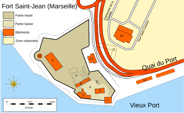
| 07:43, 26 June 2009 |  | 4,141 × 2,537 (82 KB) | Rvalette | {{Information |Description=Plan du fort Saint-Jean à Marseille avec tour du XVe siècle et fortifications du XVIIe siècle. |Source=Travail personnel réalisé avec inkscape à partir du plan numérisé de la ville de Marseille et de plans anciens (1821 |
File usage
The following pages on the English Wikipedia use this file (pages on other projects are not listed):
Global file usage
The following other wikis use this file:
- Usage on de.wikipedia.org
- Usage on fa.wikipedia.org
- Usage on fr.wikipedia.org
- Usage on nl.wikipedia.org