
File:Phet TMO 2010155 lrg.jpg
Size of this preview: 771 × 600 pixels. Other resolutions: 309 × 240 pixels | 617 × 480 pixels | 988 × 768 pixels | 1,280 × 996 pixels | 2,560 × 1,991 pixels | 7,200 × 5,600 pixels.
Original file (7,200 × 5,600 pixels, file size: 3.47 MB, MIME type: image/jpeg)
| This is a file from the Wikimedia Commons. Information from its description page there is shown below. Commons is a freely licensed media file repository. You can help. |
Summary
| Description |
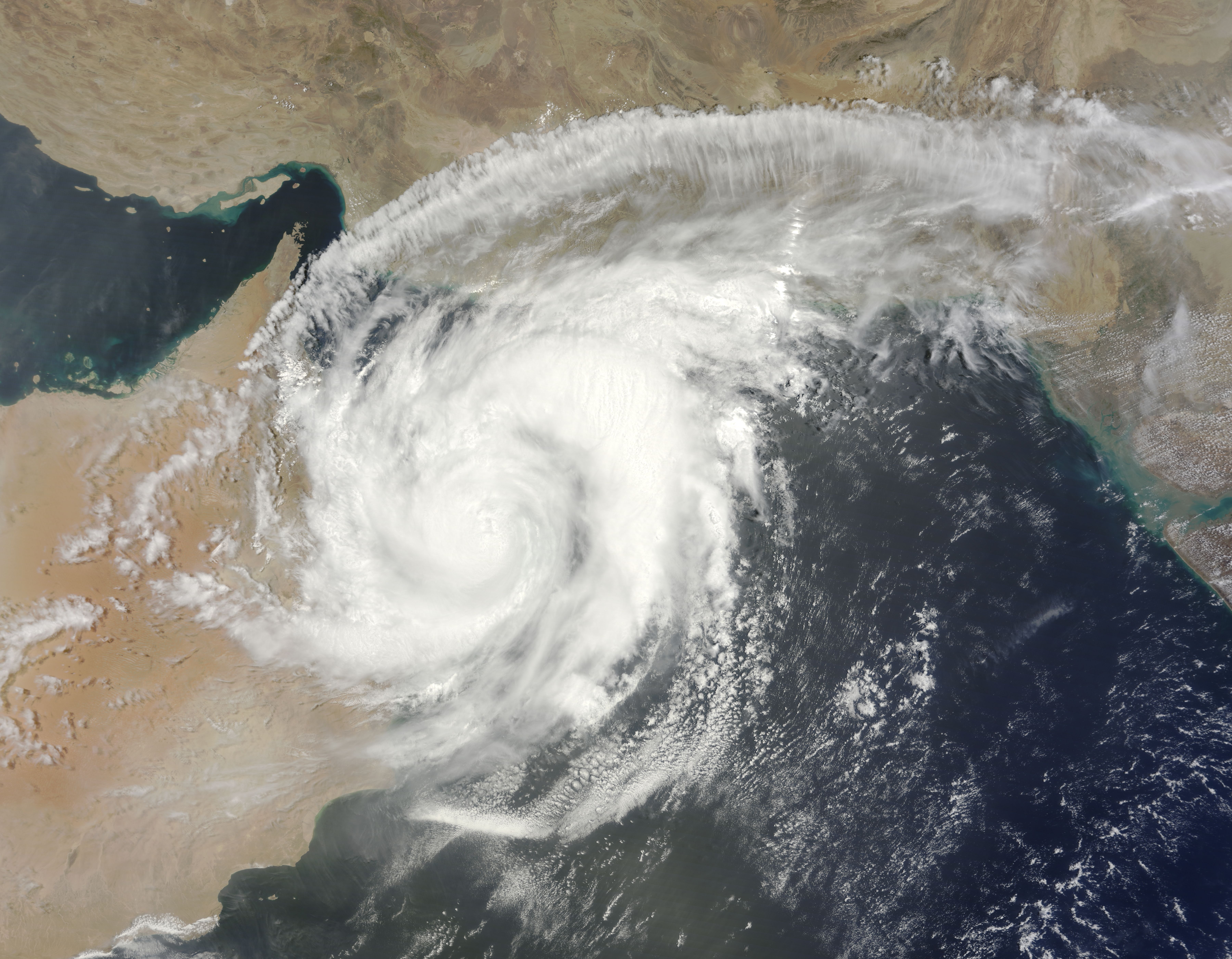
English: Once a powerful Category 4 storm, Cyclone Phet had weakened to a Category 3 storm by the time it came ashore over Oman on June 4, 2010. The Moderate Resolution Imaging Spectroradiometer (MODIS) on NASA’s Terra satellite acquired this photo-like image of the storm at 10:40 a.m. local time on June 4. By that time, Phet had degraded into a Category 1 storm with winds of about 75 knots (140 kilometers per hour or 86 miles per hour).
The storm’s swirling clouds cover most of northern Oman and all of the Gulf of Oman in this image. Though it is partially over land, the storm maintains a distinctive spiraling shape. In its northward trek over the Arabian Sea, Cyclone Phet gave Oman a glancing blow, cutting across the northeast edge of the country. The Joint Typhoon Warning Center forecast that the storm would re-emerge over the Gulf of Oman late on June 4 or early June 5, and move east towards Karachi, Pakistan, as a tropical storm. |
| Date | |
| Source | http://earthobservatory.nasa.gov/NaturalHazards/view.php?id=44189&src=nha |
| Author | NASA image courtesy Jeff Schmaltz, MODIS Rapid Response Team at NASA GSFC. Caption by Holli Riebeek. |
| Other versions |
|

Licensing
| This file is in the public domain in the United States because it was solely created by NASA. NASA copyright policy states that "NASA material is not protected by copyright unless noted". (See Template:PD-USGov, NASA copyright policy page or JPL Image Use Policy.) | ||
 |
Warnings:
|
File history
Click on a date/time to view the file as it appeared at that time.
| Date/Time | Thumbnail | Dimensions | User | Comment | |
|---|---|---|---|---|---|
| current | 00:59, 5 June 2010 | | 7,200 × 5,600 (3.47 MB) | Captain-tucker | correct image |
| 00:54, 5 June 2010 |  | 7,200 × 5,600 (337 KB) | Captain-tucker | {{Information |Description={{en|Once a powerful Category 4 storm, Cyclone Phet had weakened to a Category 3 storm by the time it came ashore over Oman on June 4, 2010. The Moderate Resolution Imaging Spectroradiometer (MODIS) on NASA’s Terra satellite a |
File usage
The following pages on the English Wikipedia use this file (pages on other projects are not listed):
Global file usage
The following other wikis use this file:
- Usage on bs.wikipedia.org
- Usage on fa.wikipedia.org
- Usage on hr.wikipedia.org
- Usage on sh.wikipedia.org