
File:Ph map cavite.png
Size of this preview: 569 × 600 pixels. Other resolutions: 228 × 240 pixels | 612 × 645 pixels.
Original file (612 × 645 pixels, file size: 76 KB, MIME type: image/png)
| This is a file from the Wikimedia Commons. Information from its description page there is shown below. Commons is a freely licensed media file repository. You can help. |
Summary
| Description |
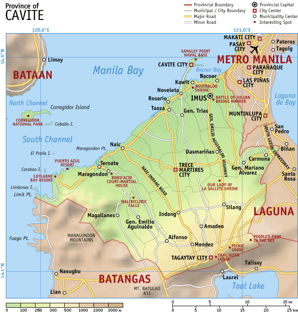
Map of the province of en:Cavite, en:Philippines. It is a topographic map showing the municipalities and cities, major and minor roads, and notable places of interest. Created and copyright (2003) by seav. Released under the GNU FDL. |
| Date | 11 October 2003 (original upload date) |
| Source | Transferred from en.wikipedia to Commons. |
| Author | The original uploader was Seav at English Wikipedia. |
Licensing

|
Permission is granted to copy, distribute and/or modify this document under the terms of the GNU Free Documentation License, Version 1.2 or any later version published by the Free Software Foundation; with no Invariant Sections, no Front-Cover Texts, and no Back-Cover Texts. A copy of the license is included in the section entitled GNU Free Documentation License. |
| This file is licensed under the Creative Commons Attribution-Share Alike 3.0 Unported license. | ||
| ||
| This licensing tag was added to this file as part of the GFDL licensing update. |
Original upload log
The original description page was here. All following user names refer to en.wikipedia.
- 2003-11-07 04:55 Seav 612×645×8 (78262 bytes) More accurate map
- 2003-10-11 11:36 Seav 612×645×8 (67091 bytes) Map of the province of Cavite, Philippines
File history
Click on a date/time to view the file as it appeared at that time.
| Date/Time | Thumbnail | Dimensions | User | Comment | |
|---|---|---|---|---|---|
| current | 14:19, 3 May 2007 | | 612 × 645 (76 KB) | Ppntori | {{Information |Description=Map of the province of en:Cavite, en:Philippines. It is a topographic map showing the municipalities and cities, major and minor roads, and notable places of interest. Created and copyright (2003) by [[:en:User:Seav|s |
File usage
The following pages on the English Wikipedia use this file (pages on other projects are not listed):
Global file usage
The following other wikis use this file:
- Usage on cbk-zam.wikipedia.org
- Usage on de.wikipedia.org
- Usage on hy.wikipedia.org
- Usage on id.wikipedia.org
- Usage on jv.wikipedia.org
- Usage on ka.wikipedia.org
- Usage on mk.wikipedia.org
- Usage on ru.wikipedia.org
- Usage on tl.wikipedia.org
- Usage on vi.wikipedia.org
- Usage on war.wikipedia.org
- Usage on zh.wikipedia.org