
File:Ph AH1N1 map.PNG
Size of this preview: 384 × 599 pixels. Other resolutions: 154 × 240 pixels | 308 × 480 pixels | 492 × 768 pixels | 656 × 1,024 pixels | 2,000 × 3,120 pixels.
Original file (2,000 × 3,120 pixels, file size: 200 KB, MIME type: image/png)
| This is a file from the Wikimedia Commons. Information from its description page there is shown below. Commons is a freely licensed media file repository. You can help. |
Summary
| Description |
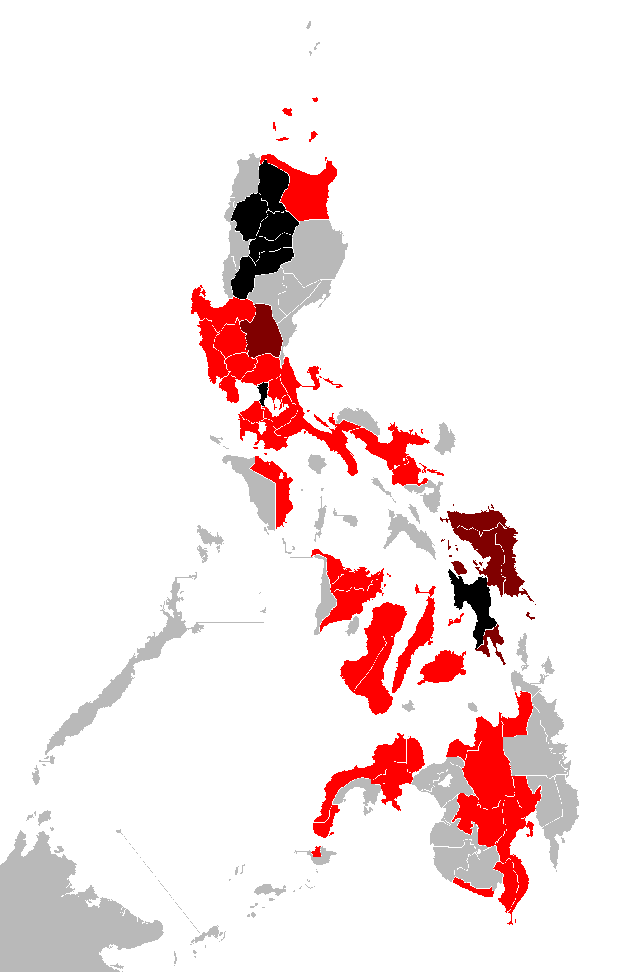
English: Map of the Philippines showing the cases of A(H1N1) flu virus.
Deaths
Confirmed community outbreak
Confirmed cases
Suspected cases Tagalog: Mapa ng Pilipinas na nagpakita ng mga kaso ng A(H1N1) flu virus.
Cebuano: Mapa sa Pilipinas nga nagpakita sa mga kaso sa A(H1N1) flu virus.
English: Colors shown:
Black - deaths Dark red -confirmed cases followed by community outbreaks Red - confirmed cases Yellow- suspected casesTagalog: Nagpakitang mga kulay:
Itim - may namatay Madilim na pula - community outbreak Pula - konpirmadong kaso Dilaw - suspetsadong kaso |
| Date | |
| Source | Own work |
| Author | Tribu akru |
| Other versions | Derivative works of this file: 2009 flu pandemic in the Philippines timeline.gif |
Licensing
| I, the copyright holder of this work, release this work into the public domain. This applies worldwide. In some countries this may not be legally possible; if so: I grant anyone the right to use this work for any purpose, without any conditions, unless such conditions are required by law. |
File history
Click on a date/time to view the file as it appeared at that time.
| Date/Time | Thumbnail | Dimensions | User | Comment | |
|---|---|---|---|---|---|
| current | 05:31, 9 August 2009 | | 2,000 × 3,120 (200 KB) | JL 09 | July 29 update |
| 04:25, 9 August 2009 |  | 2,000 × 3,120 (200 KB) | Tribu akru | Deaths in Apayao, Kalinga, Mountain Province, and Benguet. | |
| 16:00, 23 July 2009 |  | 2,000 × 3,120 (200 KB) | JL 09 | Update night of July 23 | |
| 16:47, 22 July 2009 |  | 2,000 × 3,120 (200 KB) | JL 09 | Update July 23 | |
| 16:13, 20 July 2009 |  | 2,000 × 3,120 (1.22 MB) | JL 09 | Update July 21 | |
| 11:02, 17 July 2009 |  | 2,000 × 3,120 (199 KB) | Tribu akru | Misamis Oriental, Quezon, Zamboanga City and Davao del Sur added | |
| 12:52, 26 June 2009 |  | 2,000 × 3,120 (90 KB) | Ryomaandres | new case in Kidapawan City, Cotabato | |
| 14:32, 23 June 2009 |  | 2,000 × 3,120 (199 KB) | The Wandering Traveler | Updated June 23 | |
| 12:36, 22 June 2009 |  | 2,000 × 3,120 (199 KB) | Tribu akru | {{Information |Description={{en|1=Map of the Philippines showing the cases of A(H1N1) flu virus.}} {{tgl|1=Mapa ng Pilipinas na nagpakita ng mga kaso ng A(H1N1) flu virus.}} {{ceb|1=Mapa sa Pilipinas nga nagpakita sa mga kaso sa A(H1N1) flu virus.}} {{en| |
File usage
The following pages on the English Wikipedia use this file (pages on other projects are not listed):
- 2009 swine flu pandemic in Asia
- Talk:2009 swine flu pandemic by country/Archive 2
- Talk:2009 swine flu pandemic in the Philippines
- Wikipedia talk:Tambayan Philippines/Archive 22
- File talk:H1N1 Philippines Map.svg
- File talk:Ph AH1N1 map.PNG
- Template talk:2009 flu pandemic table in the Philippines table
Global file usage
The following other wikis use this file:
- Usage on ceb.wikipedia.org
- Usage on es.wikipedia.org
- Usage on fr.wikipedia.org
- Usage on nl.wikipedia.org
- Usage on pt.wikipedia.org
- Usage on tl.wikipedia.org