
File:Península ibérica 814.svg

Size of this PNG preview of this SVG file: 800 × 555 pixels. Other resolutions: 320 × 222 pixels | 640 × 444 pixels | 1,024 × 711 pixels | 1,280 × 888 pixels | 2,560 × 1,777 pixels | 827 × 574 pixels.
Original file (SVG file, nominally 827 × 574 pixels, file size: 225 KB)
| This is a file from the Wikimedia Commons. Information from its description page there is shown below. Commons is a freely licensed media file repository. You can help. |
Summary
| Description |
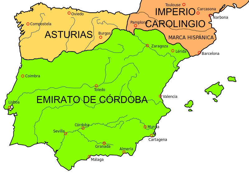
English: Map of the Iberian Peninsula in 814.
Español: Mapa de la península ibérica en 814.
Français : Carte de la péninsule ibérique en 814. |
| Date | |
| Source | File:España814.jpg, that comes from University of Texas Libraries (libertaed to public domain) |
| Author | Crates |
| Other versions |
|


Licensing
I, the copyright holder of this work, hereby publish it under the following licenses:

|
Permission is granted to copy, distribute and/or modify this document under the terms of the GNU Free Documentation License, Version 1.2 or any later version published by the Free Software Foundation; with no Invariant Sections, no Front-Cover Texts, and no Back-Cover Texts. A copy of the license is included in the section entitled GNU Free Documentation License. |
This file is licensed under the Creative Commons Attribution-Share Alike 4.0 International, 3.0 Unported, 2.5 Generic, 2.0 Generic and 1.0 Generic license.
- You are free:
- to share – to copy, distribute and transmit the work
- to remix – to adapt the work
- Under the following conditions:
- attribution – You must give appropriate credit, provide a link to the license, and indicate if changes were made. You may do so in any reasonable manner, but not in any way that suggests the licensor endorses you or your use.
- share alike – If you remix, transform, or build upon the material, you must distribute your contributions under the same or compatible license as the original.
You may select the license of your choice.
File history
Click on a date/time to view the file as it appeared at that time.
| Date/Time | Thumbnail | Dimensions | User | Comment | |
|---|---|---|---|---|---|
| current | 12:24, 4 December 2016 | | 827 × 574 (225 KB) | Kordas | ¿source for that? |
| 15:58, 24 August 2014 |  | 833 × 560 (176 KB) | Zorion | Vasconia was independant from frankish kingdom until 824 | |
| 22:54, 19 January 2009 |  | 827 × 574 (225 KB) | Phirosiberia | {{Information |Description= |Source= |Date= |Author= |Permission= |other_versions= }} | |
| 22:03, 19 January 2009 |  | 827 × 574 (193 KB) | Phirosiberia | {{Information |Description={{en|1=Map of the Iberian Peninsula in 814.}} {{es|1=Mapa de la península ibérica en 814.}} |Source=File:España814.jpg, that comes from [http://www.lib.utexas.edu/maps/historical/europe_814_colbeck.jpg University of Texa |
File usage
The following pages on the English Wikipedia use this file (pages on other projects are not listed):
Global file usage
The following other wikis use this file:
- Usage on ar.wikipedia.org
- Usage on ast.wikipedia.org
- Usage on azb.wikipedia.org
- Usage on be.wikipedia.org
- Usage on ca.wikipedia.org
- Usage on de.wikipedia.org
- Usage on el.wikipedia.org
- Usage on es.wikipedia.org
- Batalla de Roncesvalles
- Anexo:Cronología de los reinos en la península ibérica
- Reino de Navarra
- Emirato de Córdoba
- Reino de Pamplona
- Condado de Castilla
- Historia del País Vasco
- Monumentos de Oviedo y del Reino de Asturias
- Batalla del río Burbia
- Batalla de Lutos
- Historia de la provincia de Valladolid
- Batalla de las Babias
- Batalla de Mallorca (813)
- Expedición vikinga de 844
- Sitio de Barcelona (827)
- Usage on fa.wikipedia.org
- Usage on fr.wikipedia.org
- Usage on gl.wikipedia.org
- Usage on id.wikipedia.org
- Usage on it.wikipedia.org
View more global usage of this file.