
File:Peajes a ninguna parte - Autopista Radial - R3 - Viaducto sobre el arroyo Pantueña (8551954644).jpg

Size of this preview: 800 × 600 pixels. Other resolutions: 320 × 240 pixels | 640 × 480 pixels | 1,024 × 768 pixels | 1,280 × 960 pixels | 2,560 × 1,920 pixels | 3,648 × 2,736 pixels.
Original file (3,648 × 2,736 pixels, file size: 2.29 MB, MIME type: image/jpeg)
| This is a file from the Wikimedia Commons. Information from its description page there is shown below. Commons is a freely licensed media file repository. You can help. |
.jpg)
Summary
| Description |
Español: La Autopista Radial 3 o R-3 es una autopista de peaje inaugurada el 16 de febrero de 2004 con el propósito de descongestionar las salidas de Madrid en dirección Este.
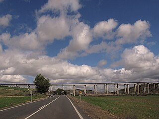
Al entrar en el término de Velilla de San Antonio, el trazado se desplaza hacia el este, para minimizar la afección al Parque Regional. Salva el Arroyo Pantueña en una zona ligeramente accidentada, mediante un viaducto de 608 m . En septiembre de 2012 la autopista se declara en suspensión de pagos, debido al poco tráfico, junto con otras autopistas radiales. Se están articulando medidas coyunturales, como la ampliación de 2012 a 2021 de la compensación por la caída del tráfico —un sistema en el que el Estado adelanta el dinero y asi lo pagamos entre todos........ hay empresas "amigas" que nunca pierden |
| Date | |
| Source | https://www.flickr.com/photos/70626035@N00/8551954644/ |
| Author | jacilluch |
| Flickr sets |
|
| Flickr pools |
|
| Flickr tags |
|
| Flickr posted date | 12 March 2013 |
| Camera location | | View this and other nearby images on: OpenStreetMap |
|---|
.jpg¶ms=040.377952_N_-003.468551_E_globe:Earth_type:camera__&language=en)
Licensing
This file is licensed under the Creative Commons Attribution-Share Alike 2.0 Generic license.
- You are free:
- to share – to copy, distribute and transmit the work
- to remix – to adapt the work
- Under the following conditions:
- attribution – You must give appropriate credit, provide a link to the license, and indicate if changes were made. You may do so in any reasonable manner, but not in any way that suggests the licensor endorses you or your use.
- share alike – If you remix, transform, or build upon the material, you must distribute your contributions under the same or compatible license as the original.
| This image was originally posted to Flickr by jacilluch at https://flickr.com/photos/70626035@N00/8551954644 (archive). It was reviewed on 27 December 2018 by FlickreviewR 2 and was confirmed to be licensed under the terms of the cc-by-sa-2.0. |
File history
Click on a date/time to view the file as it appeared at that time.
| Date/Time | Thumbnail | Dimensions | User | Comment | |
|---|---|---|---|---|---|
| current | 23:15, 27 December 2018 | | 3,648 × 2,736 (2.29 MB) | Discasto | == {{int:filedesc}} == {{information |description={{es|1=La Autopista Radial 3 o R-3 es una autopista de peaje inaugurada el 16 de febrero de 2004 con el propósito de descongestionar las salidas de Madrid en dirección Este. Al entrar en el término de Velilla de San Antonio, el trazado se desplaza hacia el este, para minimizar la afección al Parque Regional. Salva el Arroyo Pantueña en una zona ligeramente accidentada, mediante un viaducto de 608 m . En septiembre de 2012 la autopista se decla... |
File usage
The following pages on the English Wikipedia use this file (pages on other projects are not listed):
Global file usage
The following other wikis use this file:
- Usage on es.wikipedia.org
- Usage on fr.wikipedia.org
- Usage on nl.wikipedia.org
- Usage on www.wikidata.org
.jpg)