
File:Patos and Little Patos (32849967010).jpg

Original file (4,288 × 2,692 pixels, file size: 10 MB, MIME type: image/jpeg)
| This is a file from the Wikimedia Commons. Information from its description page there is shown below. Commons is a freely licensed media file repository. You can help. |
.jpg)
Summary
| Description |
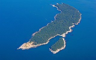
The amazing San Juan Islands of Washington State offer a plethora of incredible sights, exciting recreation opportunities, and memories for a lifetime. Situated in the northern reaches of Washington State's Puget Sound, the San Juan Islands are a uniquely beautiful archipelago of over 450 islands, rocks, and pinnacles. The new San Juan Islands National Monument encompasses approximately 1,000 acres of land spread across many of these rocks and islands and managed by the Department of the Interior's Bureau of Land Management. Drawing visitors from around the world, this is a landscape of unmatched contrasts, where forests seem to spring from gray rock and distant, snow-capped peaks provide the backdrop for sandy beaches. The San Juan Islands National Monument is a trove of scientific and historic treasures, a refuge for an array of wildlife, and a classroom for generations of Americans. On March 25, 2013, President Obama signed a proclamation to designate the San Juan Islands National Monument. The proclamation states that, "The protection of these lands in the San Juan Islands will maintain their historical and cultural significance and enhance their unique and varied natural and scientific resources, for the benefit of all Americans." To learn more about your public lands on the San Juans and to plan a warm weather visit to this uniquely beautiful locale, visit: www.blm.gov/visit Contact: San Juan Islands National Monument 37 Washburn Place Lopez Island, WA 98261 360-468-3754 BLM_OR_SP_Mail@blm.gov |
| Date | |
| Source | Patos and Little Patos |
| Author | Bureau of Land Management Oregon and Washington from Portland, America |
| Camera location | | View this and other nearby images on: OpenStreetMap |
|---|
.jpg¶ms=048.788333_N_-122.969000_E_globe:Earth_type:camera_alt:1324.353516_source:exif_heading:49.30&language=en)
Licensing
| This image is a work of a Bureau of Land Management* employee, taken or made as part of that person's official duties. As a work of the U.S. federal government, the image is in the public domain in the United States. *or predecessor organization |
| This image was originally posted to Flickr by BLMOregon at https://flickr.com/photos/50169152@N06/32849967010. It was reviewed on 2017-06-25 04:31:37 by FlickreviewR, who found it to be licensed under the terms of the cc-by-2.0, which is compatible with the Commons. It is, however, not the same license as given above, and it is unknown whether that license ever was valid. |
File history
Click on a date/time to view the file as it appeared at that time.
| Date/Time | Thumbnail | Dimensions | User | Comment | |
|---|---|---|---|---|---|
| current | 04:30, 25 June 2017 | | 4,288 × 2,692 (10 MB) | Kingofthedead | Transferred from Flickr via Flickr2Commons |
File usage
Global file usage
The following other wikis use this file:
- Usage on ceb.wikipedia.org
- Usage on vi.wikipedia.org
- Usage on www.wikidata.org
.jpg)